
Oberpierscheid
| coat of arms | Germany map | |
|---|---|---|

|
Coordinates: 50 ° 4 ′ N , 6 ° 22 ′ E |
|
| Basic data | ||
| State : | Rhineland-Palatinate | |
| County : | Eifel district Bitburg-Prüm | |
| Association municipality : | Arzfeld | |
| Height : | 530 m above sea level NHN | |
| Area : | 10.53 km 2 | |
| Residents: | 328 (Dec. 31, 2019) | |
| Population density : | 31 inhabitants per km 2 | |
| Postal code : | 54649 | |
| Area code : | 06554 | |
| License plate : | BIT, PRÜ | |
| Community key : | 07 2 32 285 | |
| Address of the municipal administration: |
Luxemburger Strasse 6 54687 Arzfeld |
|
| Website : | ||
| Local Mayor : | Peter Bormann | |
| Location of the local community Oberpierscheid in the Eifel district of Bitburg-Prüm | ||
  |
||

_(1).jpg)

Oberpierscheid is a municipality in the Eifelkreis Bitburg-Prüm in Rhineland-Palatinate . It belongs to the community of Arzfeld .
geography
The place is on a plateau of the southern Islek in the southern Eifel . The districts of Merkeshausen, Philippsweiler, Dehnseifen, Hausmannsdell, Röllersdorf, Trampelsdell and Luppertseifen belong to Oberpierscheid.
At 37%, compared to the surrounding area, a smaller proportion of the municipality is used for agriculture, 58% are forest (as of 2011).
Neighboring communities
Neighboring communities are Niederpierscheid and Mauel in the north, Heilenbach in the east, Berkoth in the south and Krautscheid in the west.
climate
The annual precipitation is 1148 mm. The rainfall is very high. They are in the upper tenth of the values recorded in Germany. Lower values are registered at 91% of the measuring stations of the German Weather Service . The driest month is July, the most precipitation falls in December. In December there is 2.6 times more rainfall than in July. The seasonal fluctuations are great. Higher seasonal fluctuations are registered at only 6% of the measuring stations .
history
The area of Oberpierscheid was probably settled in Roman times, which is suggested by grave finds from this time. The place in its current form was probably created during the late medieval clearing phases , which is indicated by the place-name ending "-scheid". The first documentary mention as "Pereschet" comes from the year 1408.
Until the end of the 18th century, the Eifelort belonged to the rulership of Neuerburg in the Duchy of Luxembourg . During French rule, he went to the canton of Arzfeld in the Forêts department . During the Prussian period, Oberpierscheid was first assigned to the Ringhuscheid mayor , and later to the Waxweiler mayor . The current districts of Oberpierscheid all emerged as new foundations in the 19th century. Mainly the workers from the Merkeshausen ironworks lived there .
On June 12, 1994, the previously independent municipality of Merkeshausen with 23 residents was incorporated.
Population development
The development of the population of Oberpierscheid in relation to today's municipal area; the values from 1871 to 1987 are based on censuses:
|
|
politics
Municipal council
The municipal council in Oberpierscheid consists of eight council members who were elected in a personalized proportional representation in the local elections on May 26, 2019 , and the honorary local mayor as chairman. The eight seats in the municipal council are divided between two groups of voters .
coat of arms
|
|
Blazon : "From silver (white) to red divided obliquely to the left, in front a green four-leaf oak branch with four acorns, behind a growing silver (white) chapel with a pointed tower dome, decorated with a black cross and two black windows." |
| Foundation of the coat of arms: Red and silver are the colors of the Counts of Vianden , who have had the Luxembourgish rule of Neuerburg on their former territory of Oberpierscheid since the 14th century . The oak branch is intended to indicate the traditional timber industry. Four leaves and four acorns should represent the four localities (Oberpierscheid, Philippsweiler, Röllersdorf and Luppertsseifen) and the four hamlets / farms (Dehnseifen, Hausmannsdell, Merkeshausen and Trampertsdell) in the coat of arms. In the lower part of the coat of arms is the chapel of St. To see Simeon; it has been documented since 1408. |
The coat of arms designed by Christian Gredner in collaboration with the citizens of Oberpierscheider was approved on April 7, 2008 by the local authority of the Eifelkreis Bitburg-Prüm.
Culture and sights

St. Simeon, interior
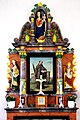
High altar

St. Margareta
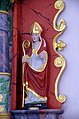
St. Nicholas
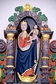
Mary with child
_03.jpg)
_05.jpg)
_08.jpg)
_10.jpg)
_12.jpg)
- Merkeshausen Castle
- Chapel, mentioned in a document as early as 1408
See also: List of cultural monuments in Oberpierscheid
Economy and Infrastructure
Today Oberpierscheid is an agricultural community . Since 1979, when 37 farms were still counted, the agricultural area has decreased from 446 ha to 431 ha (2010), which were cultivated by 7 farms.
The next Waxweiler / Schönecken motorway junction is about 6 km away on the A 60 .
Public facilities
The public facilities include a village community center, a sports field and children's playgrounds . The local community is also the location of a volunteer fire brigade with 16 members.
literature
- Ernst Wackenroder (edit.): The art monuments of the Prüm district (= Paul Clemen [Hrsg.]: The art monuments of the Rhine province . Volume 12 / II ). Trier 1983, ISBN 3-88915-006-3 , p. 173 (222 p., With 12 plates and 227 ills. In the text. Reprinted by the Schwann edition, Düsseldorf 1927).
Web links
- Internet presence of the local community Oberpierscheid
- Ortgemeinde Oberpierscheid on the webpage of the Verbandsgemeinde Arzfeld
- To search for cultural assets of the local community Oberpierscheid in the database of cultural assets in the Trier region .
Individual evidence
- ↑ State Statistical Office of Rhineland-Palatinate - population status 2019, districts, communities, association communities ( help on this ).
- ↑ State Statistical Office Rhineland-Palatinate (ed.): Official directory of the municipalities and parts of the municipality. Status: January 2018 [ Version 2020 is available. ] . S. 61 (PDF; 2.2 MB).
- ^ A b c State Statistical Office Rhineland-Palatinate - regional data
- ↑ Official municipality directory 2006 ( Memento from December 22, 2017 in the Internet Archive ) (= State Statistical Office Rhineland-Palatinate [Hrsg.]: Statistical volumes . Volume 393 ). Bad Ems March 2006, p. 191 (PDF; 2.6 MB). Info: An up-to-date directory ( 2016 ) is available, but in the section "Territorial changes - Territorial administrative reform" it does not give any population figures.
- ^ The Regional Returning Officer Rhineland-Palatinate: Local elections 2019, city and municipal council elections
- ↑ Description of the coat of arms in the bulletin of the Arzfeld community
- ^ Entry on the hunting lodge (Merkeshausen) in the database of cultural assets in the Trier region ; accessed on September 28, 2015.
- ↑ Entry on Sankt Simeon (Filialkirche) in the database of cultural assets in the Trier region ; accessed on September 28, 2015.
Arzfeld | Dackscheid | Dahnen | Daleiden | Dasburg | Eilscheid | Eschfeld | Euscheid | Großkampenberg | Hargarten | Harpelt | Herzfeld | Irrhausen | Itching | Kesfeld | Kickeshausen | Kinzenburg | Krautscheid | Lambertsberg | Lash oath | Lauperath | Leidenborn | Lichtenborn | Lierfeld | Lünebach | Lützkampen | Manderscheid | Mauel | Merlscheid | Niederpierscheid | Oberpierscheid | Olmscheid | Pintesfeld | Plütscheid | Price oath | Reiff | Reipeldingen | Roscheid | Sengerich | Sevenig (Our) | Strickscheid | Üttfeld | Waxweiler