
Okayama Prefecture
|
Okayama-ken 岡山 県 |
|
|---|---|
  |
|
| Basic data | |
| Administrative headquarters : | Okayama |
| Region : | Chūgoku |
| Main island : | Honshu |
| Area : | 7,114.33 km² |
| Water content: | 0.3 % |
| Residents : | 1,891,346 (October 1, 2019) |
| Population density : | 266 inhabitants per km² |
| Counties : | 10 |
| Municipalities : | 27 |
| ISO 3166-2 : | JP-33 |
| Governor : | Ryūta Ibaragi |
| Website: | www.pref.okayama.jp |
| Symbols | |
| Prefecture flag : |
 |
| Prefecture tree : | Japanese red pine |
| Prefecture flower : | Peach blossom |
| Vogel prefecture : | Colored pheasant |
| Prefecture song : |
Minna no kokoro ni ("In everyone's heart") |
| Education day: | November 1st |
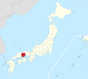
The Okayama Prefecture ( Jap. 岡山県 , Okayama-ken ) is a prefecture of Japan . It is located in the Chūgoku region on the island of Honshū and over 80 other islands . The seat of the prefecture administration is the city of the same name Okayama . Okayama was formed in the provinces of Bitchū , Bizen, and Mimasaka .
geography

Okayama Prefecture is located in the southeast of the western Japanese region of Chūgoku on the coast of the Seto Inland Sea (Setonaikai) . Three larger rivers come from the Chūgoku Mountains in the north of Okayama: in the west the Takahashigawa , on which the city of the same name and at the mouth the city Kurashiki lie, in the center of the Asahigawa , at whose mouth the city Okayama lies, and east of it the Yoshiigawa . Much of Okayama is made up of mountainous land. It also includes over 80 islands in the Inland Sea, ten of which are larger than 1 km².
With the Setonaikai National Park and the Daisen-Oki National Park , two national parks extend to parts of Okayama, in the northeast the prefecture also includes part of the quasi-national park Hyōnosen-Ushiroyama-Nagisan. There are also seven prefectural nature parks in Okayama.
history
A first prefecture (-ken) Okayama emerged in 1871 from the principality of the same name ( -han ) Okayama , in addition to which 13 further prefectures arose in the area of today's Okayama prefecture in the course of the abolition of the Han, some of which were taken over from the feudal order Prefectural subdivisions, excluding exclaves from other prefectures that were soon abolished. The area was consolidated into three prefectures in 1871: the prefecture of Oda (initially: Fukatsu) in Bitchū and part of Bingo with its administrative headquarters in Kasaoka in Oda County, the prefecture of Hokujō in Mimasaka with its administrative headquarters in Tsuyama in Hokujō County and the prefecture Okayama in Bizen, with its administrative headquarters in Okayama, Mino County. In 1875/76 Oda was divided between Okayama and Hiroshima, in 1876 Hokujō was incorporated into Okayama, whereby the prefecture was given its current boundaries, apart from minor changes due to cross-prefectural mergers, which in turn essentially correspond to the boundaries of the ancient provinces of Bitchū, Bizen and Mimasaka.
politics
Ryūta Ibaragi , former president of the Okayama-based department store chain Tenmaya, was elected to succeed Masahiro Ishii in the gubernatorial election in October 2012 and was confirmed for a second term in 2016 against just one, communist challenger with almost 90% of the votes. In parliament, the Liberal Democratic Party won an absolute majority in the April 2019 elections .
In the national parliament , Okayama is represented by five directly elected members of the Shūgiin and one per election in the Sangiin . The five Shūgiin constituencies of Okayama won five Liberal Democrats in 2017 : Ichirō Aisawa , Takashi Yamashita , Toshiko Abe , Gaku Hashimoto and Katsunobu Katō . After the 2016 and 2019 elections, Okayama will also be represented by two Liberal Democrats in Sangiin : Ex-Governor Ishii and Kimi Onoda , former local MPs in Kita (Tokyo) .
Administrative division
With the division of the prefectures ( -fu / -ken ) into the municipal forms that still exist today, in 1889 the Okayama prefecture consisted of a city ( - shi , 市 ) and 28 counties ( - gun , 郡 ), which were divided into 3 small towns ( - chō , 町 ; Tsuyama-chō, Tsuyamahigashi-chō and Takahashi-chō) and 451 villages ( - son ) were divided. As a result of incorporations and mergers, the number of municipalities fell from 402 (1920) through 119 (1955) to 78 in 1975.
Since 2007 the prefecture has been divided into 15 independent cities, 10 small towns and 2 villages. The 12 municipalities belonging to the district form the remnants of 9 rural districts, 6 of which only consist of one municipality each.
Okayama as the seat of the prefectural administration has been a “designated city” since 2009 , the second largest city in the prefecture (Kurashiki) has been a “core city” ( chūkakushi ) since 2002 .
In the following table, the districts are shown in italics, below each (indented) the small towns and the villages within them. The first two digits of the local authority code are the prefecture key of Okayama (= JP-33) as with all local authorities. The district affiliation of municipalities can be seen at the 3rd and 4th positions of the code: Since the districts are still used for statistical and geographical purposes, although they have been abolished as regional authorities since the 1920s, they were assigned to ten divisible regional authority codes ; the municipalities in the district received consecutive numbers, although mergers can result in gaps. At the beginning of the table are the 15 independent cities.
| code | Surname | Area (in km²) | population | Population density (inh / km²) |
||
|---|---|---|---|---|---|---|
| Rōmaji | Kanji | 1st October 2018 | October 1, 2019 3 | October 1, 2015 2 | ||
| 33100 | Okayama- shi | 岡山 市 | 789.95 | 720.865 | 719.474 | 910.78 |
| 33202 | Kurashiki- shi | 倉 敷 市 | 355.63 | 475.843 | 477.118 | 1341.61 |
| 33203 | Tsuyama- shi | 津 山 市 | 506.33 | 100,387 | 103,746 | 204.9 |
| 33204 | Tamano- shi | 玉 野 市 | 103.58 | 57,631 | 60,736 | 586.37 |
| 33205 | Kasaoka- shi | 笠岡 市 | 136.24 | 47.097 | 50,568 | 371.17 |
| 33207 | Ibara- shi | 井 原 市 | 243.54 | 39,172 | 41,390 | 169.95 |
| 33208 | Soja- shi | 総 社 市 | 211.90 | 68.172 | 66,855 | 315.5 |
| 33209 | Takahashi- shi | 高梁 市 | 546.99 | 29,854 | 32,075 | 58.64 |
| 33210 | Niimi- shi | 新 見 市 | 793.29 | 28,327 | 30,658 | 38.65 |
| 33211 | Bizen- shi | 備 前 市 | 258.14 | 32,832 | 35.179 | 136.28 |
| 33212 | Setouchi- shi | 瀬 戸 内 市 | 125.46 | 35,978 | 36,975 | 294.74 |
| 33213 | Akaiwa- shi | 赤 磐 市 | 209.36 | 42,628 | 43.214 | 206.41 |
| 33214 | Maniwa- shi | 真 庭 市 | 828.53 | 43,236 | 46.124 | 55.67 |
| 33215 | Mimasaka- shi | 美 作 市 | 429.29 | 26,059 | 27,977 | 65.17 |
| 33216 | Asakuchi- shi | 浅 口 市 | 66.46 | 33,063 | 34,235 | 515.12 |
| 33340 | Wake gun | 和 気 郡 | 144.21 | 14,412 | 99.94 | |
| 33346 | Wake-cho | 和 気 町 | 144.21 | 13,690 | 14,412 | 99.94 |
| 33420 | Tsukobo-gun | 都 窪 郡 | 7.62 | 12,154 | 1595.01 | |
| 33423 | Hayashima-cho | 早 島 町 | 7.62 | 12,409 | 12,154 | 1595.01 |
| 33440 | Asakuchi-gun | 浅 口 郡 | 12.23 | 10,929 | 893.62 | |
| 33445 | Satoshō-chō | 里 庄 町 | 12.23 | 10,986 | 10,929 | 893.62 |
| 33460 | Oda-gun | 小田 郡 | 90.62 | 14,201 | 156.71 | |
| 33461 | Yakage-cho | 矢 掛 町 | 90.62 | 13,549 | 14,201 | 156.71 |
| 33580 | Maniwa-gun | 真 庭 郡 | 67.11 | 866 | 12.9 | |
| 33586 | Shinjō-son | 新 庄村 | 67.11 | 815 | 866 | 12.9 |
| 33600 | Tomata-gun | 苫 田 郡 | 419.68 | 12,847 | 30.61 | |
| 33606 | Kagamino-cho | 鏡 野 町 | 419.68 | 12,071 | 12,847 | 30.61 |
| 33620 | Katsuta-gun | 勝 田 郡 | 123.56 | 17,031 | 137.82 | |
| 33622 | Shōō-chō | 勝 央 町 | 54.05 | 10,960 | 11,125 | 205.83 |
| 33623 | Nagi-cho | 奈 義 町 | 69.52 | 5549 | 5906 | 84.95 |
| 33640 | Aida gun | 英 田 郡 | 57.97 | 1472 | 25.39 | |
| 33643 | Nishiawakura-son | 西 粟 倉 村 | 57.97 | 1408 | 1472 | 25.39 |
| 33660 | Kume-gun | 久 米 郡 | 310.81 | 19,339 | 62.22 | |
| 33663 | Kumenan-cho | 久 米南 町 | 78.65 | 4578 | 4,907 | 62.39 |
| 33666 | Misaki-cho | 美 咲 町 | 232.17 | 13,297 | 14,432 | 62.16 |
| 33680 | Kaga-gun | 加 賀 郡 | 268.78 | 11,950 | 44.46 | |
| 33681 | Kibichūō-chō | 吉 備 中央 町 | 268.78 | 10,890 | 11,950 | 44.46 |
| Kojima-ko (Kojima Lake) | 児 島 湖 | 7.05 | ||||
| Shi-bu ( All shi , part of urban districts) | 市 部 | 5611.74 | 1,788,316 | 1,806,324 | 322.29 | |
| Gun-bu ( All gun , proportion of counties) | 郡 部 | 1502.59 | 111,423 | 115,201 | 76.31 | |
| 33000 | Okayama-ken (Okayama Prefecture) | 岡山 県 | 7114.33 | 1,899,739 | 1,921,525 | 270.09 |
Note: There are areas of unexplained parish affiliation, including Kojima Lake, which is included in the subtotal of urban and prefecture areas of Okayama but not counted as a parish, and one between parishes in Okayama and Kagawa.
swell
2 Results of the 2015 census
3 Estimated population 2018
Biggest places
| Census year | Residents | |||
|---|---|---|---|---|
| 2015 | 2010 | 2005 | 2000 | |
| Okayama | 719.474 | 709.584 | 674.746 | 626,642 |
| Kurashiki | 477.118 | 475,513 | 469.377 | 430.291 |
| Tsuyama | 103,746 | 106,788 | 110,569 | 90.156 |
| Soy | 66,855 | 66.201 | 66,584 | 56,531 |
| Tamano | 60,736 | 64,588 | 67,047 | 69,567 |
| Kasaoka | 50,568 | 54,225 | 57,272 | 59,300 |
| Maniwa | 46.124 | 48,964 | 51,782 | - |
| Akaiwa | 43.214 | 43,458 | 43,913 | - |
| Ibara | 41,390 | 43,927 | 45.104 | 34,817 |
| Setouchi | 36,975 | 37,852 | 39,081 | - |
| Bizen | 35.179 | 37,839 | 40.241 | 28,683 |
| Asakuchi | 34,235 | 36,114 | - | - |
| Takahashi | 32,075 | 34,963 | 38,799 | 25,374 |
| Niimi | 30,658 | 33,870 | 36,073 | 24,576 |
| Mimasaka | 27,977 | 30,498 | 32,479 | - |
November 1, 2004 - 3 municipalities merge to form the independent city of Setouchi .
March 7, 2005 - 4 parishes merge to form the independent city of Akaiwa .
March 31, 2005 - 9 municipalities merge to form the independent city of Maniwa .
March 31, 2005 - The small town of Mimasaka incorporates 5 communities and is raised to the status of an independent city .
March 21, 2006 - 3 municipalities merge to form the city of Asakuchi .
Population development in the prefecture
| Census year |
Total population |
male population |
female population |
Gender ratio men to 1000 women |
Area in km 2 |
Population density per km 2 |
|---|---|---|---|---|---|---|
| 1920 | 1,217,698 | 605.316 | 612,382 | 989 | 7018.77 | 173.5 |
| 1925 | 1,238,447 | 613.619 | 624,828 | 982 | 7018.77 | 176.5 |
| 1930 | 1,283,962 | 637.965 | 645.997 | 988 | 7046.48 | 182.2 |
| 1935 | 1,332,647 | 658.773 | 673.874 | 978 | 7046.48 | 189.1 |
| 1940 | 1,329,358 | 651.197 | 678.161 | 960 | 7046.48 | 188.7 |
| 1945 | 1,564,626 | 728.314 | 836.312 | 871 | 7046.48 | 222.0 |
| 1950 | 1,661,099 | 804.357 | 856.742 | 939 | 7059.00 | 235.3 |
| 1955 | 1,689,800 | 815.837 | 873.963 | 934 | 7059.93 | 239.4 |
| 1960 | 1,670,454 | 797.748 | 872.706 | 914 | 7059.93 | 236.6 |
| 1965 | 1,645,135 | 781.418 | 863.717 | 905 | 7063.83 | 232.9 |
| 1970 | 1,707,026 | 819.359 | 887,667 | 923 | 7077.91 | 241.2 |
| 1975 | 1,814,305 | 878.132 | 936.173 | 938 | 7078.57 | 256.3 |
| 1980 | 1,871,023 | 905.477 | 965,546 | 938 | 7086.70 | 264.0 |
| 1985 | 1,916,906 | 926.238 | 990,668 | 935 | 7089.91 | 270.4 |
| 1990 | 1,925,877 | 926.721 | 999.156 | 928 | 7111.05 | 270.8 |
| 1995 | 1,950,750 | 938,439 | 1,012,311 | 927 | 7111.05 | 274.3 |
| 2000 | 1,950,828 | 936.044 | 1,014,784 | 922 | 7112.13 | 274.3 |
| 2005 | 1,957,264 | 938,600 | 1,018,664 | 921 | 7112.73 | 275.2 |
| 2010 | 1,945,276 | 933.168 | 1.012.108 | 922 | 7113.21 | 273.5 |
| 2015 | 1,921,525 | 922.226 | 999,299 | 923 | 7114.50 | 270.1 |
Demographics

Most communities in Okayama are already seeing declining population numbers as the nationwide demographic change begins. Only the central cities of Okayama and Kurashiki and a few suburbs still saw population growth in the late 2000s. The total prefectural population declined for the first time in the five-year period between the 2005 and 2010 censuses.
The highest population density among the communities in Okayama is currently found in the small town of Hayashima, which continues to exist independently between the major cities of Kurashiki and Okayama even after the last great wave of community mergers in the 2000s.
police

The Okayama police force is one of the smaller in the country with around 3,500 police officers (2018 posts), but it is the second largest prefecture police force in the Chūgoku region after Hiroshima. It has 22 police stations: four in Mimasaka, nine in Bitchū and nine in Bizen. As in all prefectures, the police are under the supervision of the Public Security Commission, which in Okayama has five members. Three are appointed by the governor with the approval of parliament, two are nominated by the mayor and parliament of the city of Okayama, which as a designated city has additional say.
License Plate
Okayama has two license plates : Most of the prefecture, including Okayama City, uses the Okayama license plate . The Kurashiki license plate has been used in six communities in the southwest since the 2000s , even if the responsible MLIT traffic office is still in the city of Okayama and does not have its own branch in Kurashiki.

Outline

Road signs in Okayama Prefecture


Web links
Individual evidence
- ↑ Kokudo Chiriin : 平 成 26 年 全国 都 道 府 県 市区 町 村 別 面積 調 , Appendix 3 島 面積 , p. 102 [pdf: 104 of 113]: Okayama-ken, accessed on July 5, 2020
- ↑ Okayama Prefectural Administration, Environment and Culture Department: Natural Parks in Okayama
- ↑ Okayama Prefecture Administration : 岡山 県 統計 年報 平 成 25 年 版 , Appendix pp. 257ff., 岡山 県 の 沿革 , accessed on July 5, 2020 at around 5:30 p.m. CEST.
- ↑ Ishida Satoshi, 地理 デ ー タ 集 : 版 籍 奉還 か ら 廃 藩 置 県 ま で (中国 地方) and 府 県 の 変 遷 (中国 地方)
- ↑ Okayama Prefectural Parliament : MPs by Group , accessed August 9, 2019.
- ↑ 岡山 県 知事 選 現 職 の 伊 原木 隆 太 氏 が 再 選 . In: Mainichi Shimbun . October 23, 2016. Retrieved November 29, 2017 (Japanese).
- ↑ a b c Kokudo Chiriin (GSI - Geospatial Information Authority of Japan), 平 成 30 年 全国 都 道 府 県 市区 町 村 別 面積 調 (Nationwide survey of all prefectures and municipalities 2018) , p. 74 f .: 33 Okayama-ken (Japanese ), accessed March 6, 2019
- ↑ e-stat (English), accessed on January 16, 2019
- ↑ 簡 単 検 索 ・ 詳細 検 索 ・ 検 索 サ ン プ ル , accessed January 16, 2019 (Japanese)
- ↑ e-Stat database , accessed on December 16, 2018 (English)
- ↑ Iwate Prefecture Administration : 都 道 府 県 警察 官 の 定員 , accessed March 6, 2019.
- ↑ Okayama Prefecture Administration: Police (Japanese), machine translations (English, Chinese, Korean, Portuguese, Indonesian, Vietnamese)
- ↑ Okayama Prefectural Administration: Public Safety Commission (Japanese)
Aichi | Akita | Aomori | Chiba | Ehime | Fukui | Fukuoka | Fukushima | Gifu | Gunma | Hiroshima | Hokkaidō | Hyōgo | Ibaraki | Ishikawa | Iwate | Kagawa | Kagoshima | Kanagawa | Kochi | Kumamoto | Kyoto | Mie | Miyagi | Miyazaki | Nagano | Nagasaki | Nara | Niigata | Ōita | Okayama | Okinawa | Osaka | Saga | Saitama | Shiga | Shimane | Shizuoka | Tochigi | Tokyo | Tokushima | Tottori | Toyama | Wakayama | Yamagata | Yamaguchi | Yamanashi
Coordinates: 34 ° 42 ' N , 133 ° 51' E