Sargent County
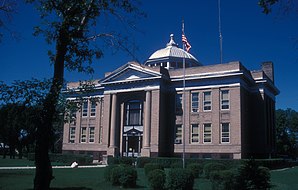
 Sargent County Courthouse (2007) |
|
| administration | |
|---|---|
| US state : | North Dakota |
| Administrative headquarters : | Forman |
| Address of the administrative headquarters: |
County Courthouse 355 Main Street Forman, ND 58032-4400 |
| Foundation : | 1883 |
| Area code : | 001 701 |
| Demographics | |
| Residents : | 4150 (2005) |
| Population density : | 1.9 inhabitants / km 2 |
| geography | |
| Total area : | 2246 km² |
| Water surface : | 22 km² |
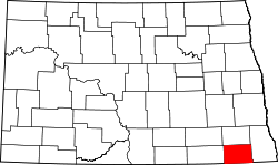
| map | |
| Website : www.co.sargent.nd.us | |
Sargent County is a county in the state of North Dakota in the United States . The county seat is Forman .
geography
The county is located in the southeast of North Dakota, borders South Dakota to the south and has an area of 2246 square kilometers, of which 22 square kilometers are water. It is bordered by counties in a clockwise direction: Ransom County , Richland County , Marshall County, South Dakota, Brown County, South Dakota, and Dickey County .
history
Sargent County was formed on March 3, 1883 and finally organized on October 8 of the same year. It was named after Homer E. Sargent , the general manager of the Northern Pacific Railroad at the time the county was created.
One building in the county is listed on the National Register of Historic Places as of April 1, 2018, the Sargent County Courthouse .
In 1997 the Lutheran Church , built in Brampton in 1908 , was closed and moved to Norway. There it was reconstructed as an émigré church .
Demographic data
| growth of population | |||
|---|---|---|---|
| Census | Residents | ± in% | |
| 1890 | 5076 | - | |
| 1900 | 6039 | 19% | |
| 1910 | 9202 | 52.4% | |
| 1920 | 9655 | 4.9% | |
| 1930 | 9298 | -3.7% | |
| 1940 | 8693 | -6.5% | |
| 1950 | 7616 | -12.4% | |
| 1960 | 6856 | -10% | |
| 1970 | 5937 | -13.4% | |
| 1980 | 5512 | -7.2% | |
| 1990 | 4549 | -17.5% | |
| 2000 | 4366 | -4% | |
| Before 1900
1900-1990 2000 |
|||
As of the 2000 census , Sargent County had 4,366 people in 1,786 households and 1,243 families. The population density was 2 people per square kilometer. The racial the population was composed of 98.24 percent white, 0.05 percent African American, 0.46 percent Native American, 0.05 percent Asian and 0.55 percent from other ethnic groups; 0.66 percent were descended from two or more races. Hispanic or Latino of any race was 0.73 percent of the population.
Of the 1,786 households, 30.3 percent had children and adolescents under the age of 18 living with them. 61.0 percent were married couples living together, 3.9 percent were single mothers, 30.4 percent were non-families, 27.7 percent were single households, and 14.1 percent had people aged 65 or over. The average household size was 2.43 and the average family size was 2.99 people.
For the entire county, the population was composed of 26.5 percent of residents under 18 years of age, 5.3 percent between 18 and 24 years of age, 25.7 percent between 25 and 44 years of age, 25.7 percent between 45 and 64 years of age 16.9 percent were 65 years of age or over. The average age was 40 years. For every 100 females there were 110.6 males. For every 100 women aged 18 or over there were statistically 110.1 men.
The median income for a household in the county is $ 37,213 , and the median income for a family is $ 44,063. Males had a median income of $ 34,222 versus $ 19,844 for females. The per capita income was $ 18,689. 6.0 percent of families and 8.2 percent families lived below the poverty line. 8.9 percent of these were children or adolescents under 18 years of age and 11.8 percent were people over 65 years of age.
See also
Web links
Individual evidence
- ↑ GNIS-ID: 1035303. Retrieved on February 22, 2011 (English).
- ↑ Charles Curry Aiken, Joseph Nathan Kane: The American Counties: Origins of County Names, Dates of Creation, Area, and Population Data, 1950-2010 . 6th edition. Scarecrow Press, Lanham 2013, ISBN 978-0-8108-8762-6 , p. 275 .
- ↑ Search mask database in the National Register Information System. National Park Service , accessed March 22, 2018.
- ^ US Census Bureau _ Census of Population and Housing . Retrieved February 17, 2011
- ↑ Extract from Census.gov . Retrieved February 21, 2011
- ↑ Excerpt from factfinder.census.gov.Retrieved February 21, 2011
- ^ Sargent County, North Dakota , 2000 census data sheet at factfinder.census.gov .
Coordinates: 46 ° 7 ′ N , 97 ° 38 ′ W

