Richland County, North Dakota
![Richland County Courthouse, listed on the NRHP with No. 80002926 [1]](https://upload.wikimedia.org/wikipedia/commons/thumb/f/f8/Richland_County_Courthouse_Wahpeton.jpg/298px-Richland_County_Courthouse_Wahpeton.jpg) Richland County Courthouse , listed on the NRHP with number 80002926 |
|
| administration | |
|---|---|
| US state : | North Dakota |
| Administrative headquarters : | Wahpeton |
| Address of the administrative headquarters: |
County Courthouse 418 2nd Avenue, N. Wahpeton, ND 58075-4400 |
| Foundation : | 1873 |
| Area code : | 001 701 |
| Demographics | |
| Residents : | 16,321 (2010) |
| Population density : | 4.4 inhabitants / km 2 |
| geography | |
| Total area : | 3744 km² |
| Water surface : | 23 km² |
| map | |
| Website : www.mylocalgov.com/richlandcountynd | |
The Richland County is a county in the US -amerikanischen State North Dakota . In 2010 , the county had 16,321 residents and a population density of 4.4 people per square kilometer. The county seat is Wahpeton .
A part of the primarily in the adjacent South Dakota lying Lake Traverse Indian Reservation the Sisseton Wahpeton Oyate , a subset of the Dakota , extends into the Richland County.
geography
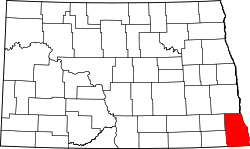
The county is located in the extreme southeast of North Dakota at the confluence of the Bois de Sioux River and Otter Tail River to form the Red River of the North . The Bois de Sioux River and the Red River form the border with Minnesota , while the southern border of the county also forms the border with South Dakota . The county covers an area of 3744 square kilometers, of which 23 square kilometers are water. It borders on the following neighboring counties:
| Cass County | ||
|
Ransom County Sargent County |

|
Wilkin County, Minnesota |
|
Roberts County, South Dakota |
Traverse County, Minnesota |
history
Richland County was formed in 1873. It was named after Morgan T. Rich , an early settler in the area.
Twelve buildings and sites in the county are listed in the National Register of Historic Places (as of April 1, 2018).
Demographic data
| Population development | |||
|---|---|---|---|
| Census | Residents | ± in% | |
| 1880 | 3597 | - | |
| 1890 | 10,751 | 198.9% | |
| 1900 | 17,387 | 61.7% | |
| 1910 | 19,659 | 13.1% | |
| 1920 | 20,887 | 6.2% | |
| 1930 | 21.008 | 0.6% | |
| 1940 | 20,519 | -2.3% | |
| 1950 | 19,865 | -3.2% | |
| 1960 | 18,824 | -5.2% | |
| 1970 | 18,089 | -3.9% | |
| 1980 | 19.207 | 6.2% | |
| 1990 | 18,148 | -5.5% | |
| 2000 | 17,998 | -0.8% | |
| 2010 | 16,321 | -9.3% | |
| Before 1900 1900–1990 2000 2010 | |||
As of the 2010 census , Richland County had 16,321 people in 6,483 households. The population density was 4.4 inhabitants per square kilometer. Statistically, 2.35 people lived in the 6,483 households.
The racial the population was composed of 95.1 percent white, 0.7 percent African American, 2.3 percent Native American, 0.6 percent Asian, 0.1 percent Polynesian and other ethnic groups; 1.3 percent were descended from two or more races. Hispanic or Latino of any race was 2.1 percent of the population.
21.2 percent of the population were under 18 years old, 63.5 percent were between 18 and 64 and 15.3 percent were 65 years or older. 48.2 percent of the population was female.
The median income for a household was 48,908 USD . The per capita income was $ 25,835. 10.6 percent of the population lived below the poverty line.
Richland County localities
structure
Richland County is divided into 14 cities and 36 townships :
See also
Individual evidence
- ^ Extract from the National Register of Historic Places.Retrieved March 13, 2011
- ↑ GNIS-ID: 1035302. Retrieved on February 22, 2011 (English).
- ↑ a b c U.S. Census Bureau, State & County QuickFacts - Richland County, MN Retrieved July 15, 2013
- ↑ a b National Association of Counties. Retrieved July 15, 2013
- ↑ Search mask database in the National Register Information System. National Park Service , accessed April 1, 2018, 2018.
- ^ US Census Bureau _ Census of Population and Housing.Retrieved February 17, 2011
- ^ Extract from Census.gov.Retrieved February 21, 2011
- ↑ Missouri Census Data Center - North Dakota ( page no longer available , search in web archives ) Info: The link was automatically marked as defective. Please check the link according to the instructions and then remove this notice. Retrieved July 15, 2013
Web links
Coordinates: 46 ° 16 ′ N , 96 ° 57 ′ W
