
Sarmizegetusa (Hunedoara)
|
Sarmizegetusa Várhely castle town |
|||||
|
|||||
| Basic data | |||||
|---|---|---|---|---|---|
| State : |
|
||||
| Historical region : | Transylvania | ||||
| Circle : | Hunedoara | ||||
| Coordinates : | 45 ° 31 ' N , 22 ° 47' E | ||||
| Time zone : | EET ( UTC +2) | ||||
| Height : | 493 m | ||||
| Area : | 73.12 km² | ||||
| Residents : | 1,209 (October 20, 2011) | ||||
| Population density : | 17 inhabitants per km² | ||||
| Postal code : | 337415 | ||||
| Telephone code : | (+40) 02 54 | ||||
| License plate : | HD | ||||
| Structure and administration (as of 2016) | |||||
| Community type : | local community | ||||
| Structure : | Sarmizegetusa, Breazova , Hobița-Grădişte , Păucineşti , Zeicani | ||||
| Mayor : | Adrian-Claudiu-Dumitru Cordoș ( PSD ) | ||||
| Postal address : | Str. Principală, no. 4 loc. Sarmizegetusa, jud. Hunedoara, RO-337415 |
||||
| Website : | |||||


Sarmizegetusa (outdated Grădişte ; German Burgort , Hungarian Várhely ) is a municipality in the Hunedoara district in the Transylvania region in Romania .
Geographical location

The municipality of Sarmizegetusa is located in the Hațeg depression (Depresiunea Hațegului) - the foothills of the Transylvanian Alps - northwest of the Retezat Mountains (Munții Retezat) and northeast of the Țarcu Mountains (Munții Țarcu) . Located on the river Breazova and the national road Drum național 68 ( Caransebeş - Hațeg ), the nearest town Hațeg (Hatzeg) is 16 kilometers northeast; the district capital Deva (Diemrich) is about 60 kilometers north (41 km as the crow flies).
history
Located on a historic Roman road , the place was first mentioned in 1398. As one of the oldest Romanian hearing villages of the Hațeg depression, the place was next to the ruins of the capital of the Roman province of Dacia , the so-called Colonia Ulpia Traiana Augusta Dacica Sarmizegetusa . Numerous finds from archaeological excavations in the region, however, point to settlement as far back as the Neolithic Age .
population
In 1850 there were 2642 inhabitants in the area of today's municipality; 2566 of them were Romanians , 38 Roma , 33 Magyars and 5 Transylvanian Saxons . In 1890 the largest population was determined with 2911 and at the same time that of the Romanians (2828) and that of the Germans (22). The highest number of Hungarians (121) was registered in 1910 and that of Roma in 1850. In addition, two in 1910 and one in 1930 called themselves Serbs . At the 2002 census there were 1388 people living in the municipality, 1381 of whom were Romanians, three Magyars and four Romanian Germans .
Attractions
- The ruins of a fortress, the former Roman capital of Dacia Colonia Ulpia Traiana , built under Emperor Trajan between 108 and 110 AD, who Emperor Hadrian added the name Sarmizegetusa - derived from the former center of the Dacian Empire, Sarmizegetusa Regia , which the Romans destroyed before had - is a listed building. The rectangular property covered an area of about 32 hectares. The 1.80 meter thick and 4-5 meter high walls extended over a length of 450 meters in north-south direction and 600 meters in east-west direction. There were defensive towers at all corners of the complex, an entrance gate on each side and a water ditch around 4–5 meters wide. The most important building in the complex was the Augustus Palace ( aedes augastalium , 85 × 65 m), made of stone, bricks and marble. To the south of the palace was the public market square in two parts; a narrow one (85 × 10 m) adorned with statues and sculptures and a larger part (42 m wide, as not yet fully explored, length unknown). This was paved with stone slabs and had a channel for the rainwater. After AD 271 the city fell into disrepair; it was probably a ruin in the 13th century. The building materials for the churches in Densuș and Strei came from here.
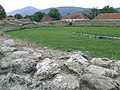
- The ruins of an amphitheater are located 190 meters north of Ulpia Traiana Sarmizegetusa , next to the national road. It is the only known amphitheater in Dacia. Its oval shape is 88 × 69 meters in length; the arena is 66 × 47 m. There was a three meter high wall between the arena and the stands. The outer walls were about eight meters high; there were 12 access gates. In the middle of the arena was a trench two meters deep.
- The village museum of the municipality.

Plan of Ulpia Traiana and the surrounding area
View of the ruins of the amphitheater

360 ° view of the amphitheater

Mayor's office of the municipality
.JPG)


Web links
Individual evidence
- ↑ 2011 census in Romania at citypopulation.de
- ↑ a b c d Heinz Heltmann, Gustav Servatius (Ed.): Travel Guide Siebenbürgen. Kraft, Würzburg 1993, ISBN 3-8083-2019-2 .
- ^ Dictionary of the localities in Transylvania
- ↑ a b c Institute Of Archeology - Sarmizegetusa, accessed on November 20, 2010 (Romanian)
- ↑ Census, last updated November 2, 2008, p. 138 (Hungarian; PDF; 1.1 MB)
- ↑ Website of Ulpia Traiana Sarmizegetusa, on www.cimec.ro (Romanian)
- ↑ List of historical monuments of the Romanian Ministry of Culture, updated 2010 (PDF; 7.10 MB)
Băcia | Baia de Criș | Băița | Balșa | Bănița | Baru | Bătrâna | Beriu | Blăjeni | Boșorod | Brănișca | Bretea Română | Buceș | Bucureșci | Bulzeștii de Sus | Bunila | Burjuc | Cârjiți | Cerbăl | Certeju de Sus | Crișcior | Densuș | Dobra | General Berthelot | Ghelari | Gurasada | Hărău | Ilia | Lăpugiu de Jos | Read | Lunca Cernii de Jos | Luncoiu de Jos | Mărtineşti | Orăştioara de Sus | Pestișu Mic | Pui | Răchitova | Rapoltu Mare | Râu de Mori | Ribița | Romos | Sălașu de Sus | Sântămăria-Orlea | Sarmizegetusa | Șoimuș | Teliucu Inferior | Tomeşti | Toplița | Totești | Turdaș | Vălișoara | Vața de Jos | Vețel | Vorța | Zam