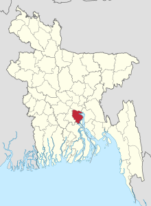
Shariatpur (district)
Shariatpur ( Bengali : শরিয়তপুর ) is an administrative district in central Bangladesh , which is within the Dhaka Division , the superordinate administrative unit. In the capital of the district forms the city of the same name Shariatpur . The total area of the district is 1174 km². The district consists of the 6 Upazilas Bhedarganj, Damudya, Gosairhat, Naria, Shariatpur Sadar and Zajira. The Shariatpur district was named after Hazi Shariatullah , who was a distinguished personality and renowned pir (pious man) of this region.
Shariatpur district is bounded by Munsiganj district to the north, Chandpur to the east, Barishal to the south and Madaripur to the west . The river Padma forms the eastern border . The district has 1.2 million inhabitants (2011 census). The literacy rate is 47.3% of the population. 95% of the population are Muslim and 4.9% are Hindus .
The climate is tropical and warm all year round. The annual average temperature of this district varies from a maximum of 35.8 degrees Celsius to a minimum of 12.6 degrees. The annual rainfall is 2105 mm (2011) and the humidity is high.
The economy of the district is dominated by agriculture . According to the 2011 census, 60.5% of the workforce work in agriculture, 30.2% in the service sector (mostly in informal settings) and 9.3% in industry .
education
There are 13 Madrasas , 30 Primary Schools, 2 Junior Secondary Schools, 23 Secondary Schools, 1 Technical School, 2 Colleges and 1 University in Shariatpur. There are also 4 libraries .
Individual evidence
- ↑ a b District Statistics 2011 Shariatpur. Retrieved August 3, 2019 .
- ↑ a b Shariatpur (District (Zila), Bangladesh) - Population Statistics, Charts, Map and Location. Retrieved August 4, 2019 .
- ^ Shariatpur Government: Shariatpur District. Retrieved February 27, 2020 (English).
