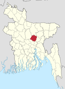
Gazipur (District)
Gazipur ( Bengali : গাজীপুর ) is an administrative district in central Bangladesh , which is within the Dhaka Division , the superordinate administrative unit. In the capital of the district forms the city of the same name Gazipur . The total area of the district is 1806.36 km², of which 17.53 km² are water and 273.42 km² are forest.
The Gazipur district borders on Mymensingh and Kishoreganj to the north, Narsingdi to the east, the Naranyanganj and Dhaka districts to the south, and Tangail district to the west . The district contains 5 Upazilas , 4 parishes, 44 Union Council and 1114 villages. The district has 3.4 million inhabitants (2011 census). The literacy rate is 62.6% of the population. 92.3% of the population are Muslim and 7.5% are Hindus . Agriculture predominates almost everywhere in the district.
The annual average temperature of this district varies from a maximum of 36 degrees Celsius to a minimum of 12.7 degrees. The annual rainfall is 2,376 mm and the humidity is high.
The current district was created in 1984 from parts of the Dhaka district.
Individual evidence
- ↑ a b District Statistics 2011 Gazipur. Retrieved August 3, 2019 .
- ^ Gazipur (District (Zila), Bangladesh) - Population Statistics, Charts, Map and Location. Retrieved August 4, 2019 .
