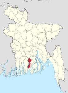
Pirojpur (district)
Pirojpur ( Bengali : পিরোজপুর জেলা , Pirojapur jelā ) is an administrative district in southwestern Bangladesh , which is within the Barishal Division . The district has a population of 1,113,257 (2011 census).
The 1307.61 km² district borders on the Gopalganj and Barishal districts in the north, on Jhalokathi in the east, on Barguna in the south and on the Bagerhat district in the west .
The main rivers are the Baleshwar , Katcha , Kaliganga and Sandhya .
Pirojpur is divided into the seven Upazilas Bhandria, Kawkhali, Mathbaria, Nazirpur, Nesarabad, Pirojpur Sadar and Zianagar. Within this administrative division there are 51 Union Parishads (village councils), 645 villages and three cities.
The largest city in the district is Pirojpur , which was founded in 1886 and has over 50,000 residents.
Web links
Coordinates: 22 ° 35 ' N , 90 ° 0' E
