
Chittagong (District)
| Chittagong District | |
|---|---|
 |
|
| Basic data | |
| Country | Bangladesh |
| division | Chittagong |
| Seat | Chittagong |
| surface | 5283 km² |
| Residents | 7,616,352 (2011) |
| density | 1442 inhabitants per km² |
| ISO 3166-2 | BD-10 |
| Website | chittagong.gov.bd |
Coordinates: 22 ° 15 ' N , 91 ° 50' E
The Chittagong District ( Bengali : চট্টগ্রাম জেলা , Caṭṭagrām jelā , Chottogram jela ) is an administrative unit in southeastern Bangladesh , which is within the Chittagong Division . The district has 7,616,352 inhabitants (2011 census), making it the second largest district in the country by population after Dhaka .
geography
The 5282.98 km² district borders in the north on the neighboring district of Feni and the Indian state of Tripura , in the east on the districts Bandarban , Rangamati and Khagrachhari , in the south on the district Cox's Bazar and in the west on the district Noakhali and the Bay of Bengal .
The main rivers are the Karnafuli , Halda and Sangu .
Nature and wildlife
The natural vegetation consists of rainforests, deciduous forests, bamboo forests, ferns and grasslands.
Wildlife includes elephants, leopards, wild cats, wild dogs and more than 600 different species of birds. Flora and fauna resemble those of the neighboring state of Myanmar and not the Indian flora and fauna.
Agricultural areas are often created by slash and burn (Jhum in Bengali). This and soil erosion in areas with deforestation are the main reasons for the change in the landscape.
climate
The climate is subtropical and the temperatures vary between 16.1 ° C and 34.8 ° Celsius. The average annual rainfall is 4285 mm. The average humidity is usually more than 70%. There is little rain in the months from November to March. June, July and August are the months with the most rain.
history
Chittagong has been a settlement area with a seaport since ancient times . Arab sea traders were already trading through the port in the 9th century. The region was under the influence of the Kingdom of Arakan in the sixth and seventh centuries . Before Islam spread in the region, Burmese kings asserted their sphere of influence. In the 13th century, troops of the Sultanate of Delhi conquered the area. It later fell back to Arakan. Sultan Fakruddin Mubarak Shah of Sonargaon conquered Chittagong in 1340. With the defeat of Sultan Giasuddin Mahmud Shah in 1538, who fought on behalf of Sher Shah , Chittagong again came under the influence of the Kingdom of Arakan. From then on, the Chittagong region was controlled by the Portuguese and the so-called Magh pirates . Bujurg Umed Khan, a general of the Mughals, drove the Portuguese out of the area in 1666 and incorporated the area into the Mughal Empire . Meanwhile the city was renamed Islamabad (place of Islam). As early as 1685 the British East India Company tried in vain with a fleet under the command of Admiral Nicholson to conquer the port, city and surroundings of Chittagong. In 1760, the region fell to the British who, until the partition of India in 1947, mainly expanded the port for the transport of goods. After the Burmese conquered the Arakan Empire in 1784, many refugees came to the area. The Burmese policy of conquest led to the First Anglo-Burmese War in 1824 . During the sepoy uprising , parts of the Indian troops mutinied in Chittagong. In 1930 it came to the Chittagong uprising of the Indian Republic Army led by Surya Sen . The uprising was successfully fought by British troops and militia loyal to England, and the leader Sen was executed after a trial. During World War II, the area was near the front line between the British and Japanese. The Japanese Air Force bombed Chittagong in April and May 1942. Since independence from the British, it was part of East Pakistan, which became Bangladesh in 1971. Severe destruction by the Pakistani military during the 1971 War of Liberation. In this region, Mujibur Rahman proclaimed the independence of Bangladesh from Pakistan in a radio address. Since the separation of the Cox's Bazar district in 1984, the Chittagong district has the current size.
population
Population development
As everywhere in Bangladesh, the population in the district has been growing rapidly for decades. The following table illustrates this:

Significant places
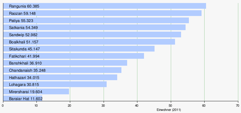
The largest city in the district is Chittagong, with a population of more than three million (2011: 2,582,401 inhabitants). Other towns and important places are Banshkhali , Baraiar Hat , Boalkhali , Chandanaish , Fatikchari , Hathazari , Lohagara , Mirersharai , Patiya , Rangunia , Raozan , Sandwip , Satkania and Sitakunda . Other places with more than 25,000 inhabitants are Kutubdia (also called Baraghop), Pekua, Ramu and Uhalapalong (also called Ukhia). The urban population makes up a total of percent of the total population. The following table (without Chittagong) shows the population of these cities:
administration
Already in 1666 created the administrative district of Chittagong, initially involved since 1860 as a Hill Tracts and now in three self-governing districts divided mountainous region on the border with India and Myanmar .
The district is divided into 15 Upazilas and the city of Chittagong: Anwara, Banshkhali, Boalkhali, Chandanaish, Chittagong City Corporation, Fatikchhari, Hathazari, Karnaphuli (created in 2016), Lohagara, Mirsharai, Patiya, Rangunia, Raozan, Sandwip, Satkania and Sitakunda. Chittagong itself has ten boroughs. Within this administrative subdivision there is the city administration of the metropolis of Chittagong , nine self-governing cities ( municipalities ), 194 Union Parishads (village councils) and 1267 villages.
economy
In total there are (2011) 5,951,044 people who are older than 10 years and who are not employees or self-employed. Of these, 1,848,337 people are in school, 75,196 people are looking for work and 1,753,675 people work in a household. 2,273,836 people are gainfully employed. Of these, 394,670 (= 17.4 percent) work in agriculture and fishing, 552,735 in industry and 1,326,411 in services.
The seaport, located at the mouth of the Karnafuli, is Bangladesh's largest transshipment point for tea, leather, dried fish and textiles.
health
There are several government and private hospitals in Chittagong and a health center in each subdistrict. There are also smaller health centers and family planning centers at the local level.
traffic
There are two railway lines in the district. The less important railway line runs from Chittagong to Satkania. The route from Chittagong to the north (to Dhaka) is more important. However, large parts of the district have no rail connection. Therefore, the regional traffic is mostly handled with auto rickshaws and minibuses and the supraregional traffic with buses. The Chittagong Circular Railway (also called Chittagong Metro Rail) has been operating in and around Chittagong since 2011.
literature
- Jasim Uddin Harun: Chittagong District . In: Asiatic Society of Bangladesh (Ed.): Banglapedia - the National Encyclopedia of Bangladesh . 2nd Edition. 2012 (English, banglapedia.org ).
Web links
- Article on Chittagong District at Banglapedia
- Chittagong at the 2011 census
- Zila Chittagong at the 2011 census
| Barishal |
Barguna • Barishal • Bhola • Jhalokathi • Patuakhali • Pirojpur |
|
| Chittagong |
Bandarban • Brahmanbaria • Chandpur • Chittagong • Cox's Bazaar • Feni • Khagrachhari • Kumilla • Lakshmipur • Noakhali • Rangamati |
|
| Dhaka |
Dhaka • Faridpur • Gazipur • Gopalganj • Kishoreganj • Madaripur • Manikganj • Munsiganj • Narayanganj • Narsingdi • Rajbari • Shariatpur • Tangail |
|
| Khulna |
Bagerhat • Chuadanga • Jessore • Jhinaidah • Khulna • Kushtia • Magura • Meherpur • Narail • Satkhira |
|
| Maimansingh |
Jamalpur • Maimansingh • Netrakona • Sherpur |
|
| Rajshahi |
Bogra • Jaipurhat • Naogaon • Natore • Nawabganj • Pabna • Rajshahi • Sirajganj |
|
| Rangpur |
Dinajpur • Gaibandha • Kurigram • Lalmonirhat • Nilphamari • Panchagarh • Rangpur • Thakurgaon |
|
| Sylhet |
Habiganj • Moulvibazar • Sunamganj • Sylhet |