
Sylhet (division)
|
সিলেট বিভাগ Sylhet
|
|
|---|---|
  |
|
| Basic data | |
| Country | Bangladesh |
| Capital | Sylhet |
| surface | 12,596 km² |
| Residents | 11,291,000 (2016) |
| density | 896 inhabitants per km² |
| ISO 3166-2 | BD-G |
| Website | sylhetdiv.gov.bd (Bengali) |
Coordinates: 24 ° 30 ' N , 91 ° 42' E
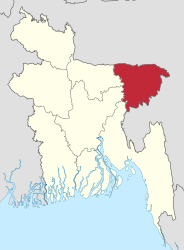
The Sylhet Division ( Bengali : সিলেট বিভাগ , Sileṭ bibhāg , Silet Bibhag ) is one of eight administrative units in Bangladesh , which are superordinate to the districts and are named after their largest city. With an area of 12,595.95 km², it is one of the smallest administrative units and is located in the far northeast of the country. The division's population is around 11 million (2011). The administrative capital is the city of the same name Sylhet .
The Sylhet division is bordered to the north by the Indian state of Meghalaya , to the east by the Indian state of Assam , to the south by the Indian state of Tripura , and to the west by the Maimansingh , Dhaka and Chittagong divisions .

The administrative unit consists of only four districts and has 14 city administrations and numerous local sub-administrative categories. The four districts are: Habiganj , Moulvibazar , Sunamganj and Sylhet .
After a referendum on July 6, 1947, East Pakistan, now known as Bangladesh, which was part of the undivided Assam before the partition of India , was incorporated. After Bangladesh gained independence in 1973, the area initially belonged to the Chittagong division. On August 1, 1995, the new (sixth) Sylhet Division was formed from the four districts mentioned.
Population development
| year | population |
|---|---|
| 1991 census | 6,765,039 |
| 2001 census | 7,939,343 |
| 2011 census | 9.910.219 |
| 2016 estimate | 11,291,000 |
Web links
Individual evidence
- ^ Sylhet Division. Banglapedia, accessed June 1, 2020 .
| Barishal |
Barguna • Barishal • Bhola • Jhalokathi • Patuakhali • Pirojpur |
|
| Chittagong |
Bandarban • Brahmanbaria • Chandpur • Chittagong • Cox's Bazaar • Feni • Khagrachhari • Kumilla • Lakshmipur • Noakhali • Rangamati |
|
| Dhaka |
Dhaka • Faridpur • Gazipur • Gopalganj • Kishoreganj • Madaripur • Manikganj • Munsiganj • Narayanganj • Narsingdi • Rajbari • Shariatpur • Tangail |
|
| Khulna |
Bagerhat • Chuadanga • Jessore • Jhinaidah • Khulna • Kushtia • Magura • Meherpur • Narail • Satkhira |
|
| Maimansingh |
Jamalpur • Maimansingh • Netrakona • Sherpur |
|
| Rajshahi |
Bogra • Jaipurhat • Naogaon • Natore • Nawabganj • Pabna • Rajshahi • Sirajganj |
|
| Rangpur |
Dinajpur • Gaibandha • Kurigram • Lalmonirhat • Nilphamari • Panchagarh • Rangpur • Thakurgaon |
|
| Sylhet |
Habiganj • Moulvibazar • Sunamganj • Sylhet |