
Bandarban (District)
| Bandarban District | |
|---|---|
 |
|
| Basic data | |
| Country | Bangladesh |
| division | Chittagong |
| Seat | Bandarban |
| surface | 4479 km² |
| Residents | 388,335 (2011) |
| density | 87 inhabitants per km² |
| ISO 3166-2 | BD-01 |
| Website | bandarban.gov.bd |
Coordinates: 21 ° 29 ' N , 92 ° 14' E
The Bandarban District ( Bengali : বান্দরবান জেলা , Bāndarabān jelā ) is an administrative unit in southeastern Bangladesh , which is within the Chittagong Division . The capital in the northern part of the district is also called Bandarban . The district has 388,335 inhabitants (2011 census).
geography
The 4479 km² district is the southern part of the mountainous region of Chittagong Hill Tracts and was first built in 1900. It borders in the north and east on the neighboring district of Rangamati and the provinces of Rakhaing and Chin of the eastern neighboring country Myanmar , in the south on the River Naf and in the west the national districts of Chittagong and Cox's Bazar . The most important rivers of the district, which is dominated by two thirds of forests and mountains, are the Bakkhali , Matamuhuri and the Shankha ( Sangu ). The four main mountains of Bandarbans are Meranja , Wailatong , Tambang and Politai .
The highest mountain in Bangladesh is located in the Bandarban district. However, it is still unclear whether this is the Keokradong in the southeast of the Upazila Ruma or the Mowdok Mual in the Upazila Thanchi.
Nature and wildlife
The natural vegetation consists of rainforests, deciduous forests, bamboo forests, ferns and grasslands.
Wildlife includes elephants, leopards, wild cats, wild dogs and more than 600 different species of birds. Flora and fauna correspond to those of the neighboring state of Myanmar and not the Indian flora and fauna.
Agricultural areas are often created by slash and burn (Jhum in Bengali). This and soil erosion in areas with deforestation are the main reasons for the change in the landscape.
climate
The temperatures fluctuate between 12.5 ° C and 37 ° Celsius. The average annual rainfall is 3031 mm. The average humidity is around 70%. There is little rain in the months from November to March. June, July and August are the months with the most rain.
history
In the 9th century the area was part of the Kingdom of Arakan. Later in the Middle Ages it belonged to the Sultanate of Bengal as a vassal territory of Mrauk U and then to the Mughal Empire . At times, however, the region was also ruled by the Kingdom of Arakan and the princely state of Tippera (also called Tripura). From 1666 on, local rulers paid tribute to the Mughal Empire. The weakened Mughal Empire left the area to the British in 1760. From then until 1860 these were limited to the payment of annual taxes. The area became part of the Bengal Presidency in 1860 . But the area of today's Bandarban district could not be finally subjugated until 1891. After that, it was part of the Chittagong Hill Tracts area . Since gaining independence from the British, it was part of East Pakistan that became Bangladesh in 1971. In the War of Independence of East Pakistan (now Bangladesh) the hill tribes were more towards the previous state of Pakistan, because they wanted to reduce the strong Bengali pressure on their settlement areas. The district was created in 1959 by splitting the previous Chittagong Hill Tracts district into various sub-districts. It has existed in its current form since 1981.
population
Population development
As everywhere in Bangladesh, the population in the district has been growing rapidly for decades. A special problem for the local population is the immigration of numerous Bengalis. Less than half of the population were born in the district.

age structure
As everywhere in Bangladesh, the population is on average very young. The average age at the last census in 2011 was 19.95 years with a slightly increasing trend.
The 2011 census showed the following age structure:
| Age | 0–9 years | 10–19 years | 20-29 years | 30–39 years | 40-49 years | 50–59 years | 60–69 years | 70–79 years | 80 years and more | ||||
| number | 109.163 | 79,036 | 70,601 | 51,619 | 35.107 | 22,033 | 12,560 | 5767 | 2449 | ||||
| proportion of | 28.11% | 20.35% | 18.18% | 13.29% | 9.04% | 5.67% | 3.23% | 1.48% | 0.63% | ||||
| Source: Zila Bandarban, table P14, page 320 | |||||||||||||
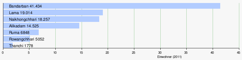
Significant places
The most populous place within the district is the district capital Bandarban . The only other town is Lama . But with Alikadam and Naikhongchhari there are two other places without municipal rights with more than 10,000 inhabitants. The urban population makes up only 25.86 percent of the total population. The main towns of the seven Upazilas have the following population figures:
District population by gender
As in many parts of Bangladesh, the proportion of the female population is lower than the number of male residents.
| Distribution of the population by gender in Bandarban district | ||||||||||
| 1974 census | 1981 census | 1991 census | 2001 census | 2011 census | ||||||
| number | proportion of | number | proportion of | number | proportion of | number | proportion of | number | proportion of | |
| TOTAL | 116,426 | 100% | 171,478 | 100% | 230,569 | 100% | 298.120 | 100% | 388.335 | 100% |
| Men | 61,519 | 52.84% | 94.006 | 54.82% | 125,730 | 54.53% | 162.133 | 54.39% | 203,350 | 52.36% |
| Women | 54,907 | 47.16% | 77,472 | 45.18% | 104,839 | 45.47% | 135.987 | 45.61% | 184,985 | 47.64% |
| Source: Zila Bandarban in the 2011 census, table PT-02, page 17 | ||||||||||
Ethnic groups
There are more and more Bengali immigrants. These make up the majority of the population today. Nevertheless, at the last census in 2011, 172,401 people (44.39 percent of the population) counted themselves as “tribals”. They are known by the government of Bangladesh under the collective name Jumma . In reality, the term encompasses an extremely diverse range of peoples. In the district these are the eleven peoples of the Marma (77,477 people in the district), Murong (also called Mro; 38021 people), Tripuri (20,685 people), Bawm , Tanchangya , Chakma , Chak , Khyang , Khumi , Lushei and Pankho . In the sub-districts Rowangchhari (24,745 of the 27,264 inhabitants), Ruma (26,503 of the 29,038 inhabitants) and Thanchi (21,426 of the 23,591 inhabitants) they are clearly in the majority. Only in the Rowangchhari sub-district does a single minority people - the Marma - make up the majority of the population with 14,300 of 27,264 inhabitants (52.45 percent of the population). In all other sub-districts there are several minority ethnic groups - without constituting the majority of the population.
religion
Nowadays, due to the immigration of mostly Muslim Bengali, a slim majority is Islamic. But in contrast to the rest of the Muslim-dominated country, Bandarban has a significant number of Buddhists and Christians. On the coast, Muslims are in the majority, in the eastern half Buddhists, Christians and followers of traditional religions dominate. In Upazila Rowangchhari, almost 70% of the population are Buddhists, in Upazilas Ruma and Thanchi over 35% are Christians.
| year | Buddhists | Christians | Hindus | Muslims | Other | Total | ||||||||||||
|---|---|---|---|---|---|---|---|---|---|---|---|---|---|---|---|---|---|---|
| number | proportion of | number | proportion of | number | proportion of | number | proportion of | number | proportion of | number | proportion of | |||||||
| 1981 | 75172 | 43.84% | 13,737 | 8.01% | 4582 | 2.67% | 71,440 | 41.66% | 6547 | 3.82% | 171,478 | 100.00% | ||||||
| 1991 | 87,613 | 38.00% | 16,769 | 7.27% | 8105 | 3.52% | 109,800 | 47.62% | 8282 | 3.59% | 230,569 | 100.00% | ||||||
| 2001 | 103.997 | 34.88% | 28,546 | 9.58% | 10,796 | 3.62% | 147.062 | 49.33% | 7719 | 2.59% | 298.120 | 100.00% | ||||||
| 2011 | 123.052 | 31.19% | 39,333 | 10.13% | 13,137 | 3.38% | 197.087 | 50.75% | 15,726 | 4.05% | 388.335 | 100.00% | ||||||
| Source: 1981, 1991, 2001 and 2011 census results | ||||||||||||||||||
In the seven Upazilas (sub-districts) the distribution is as follows:
| Population in the district's Upazilas by religion | ||||||||||||||||||
| Upazila | TOTAL | Muslims | Hindus | Buddhists | Christians | |||||||||||||
| Residents | number | proportion of | number | proportion of | number | proportion of | number | proportion of | ||||||||||
| Alikadam | 49317 | 26680 | 54.10% | 1655 | 3.36% | 15233 | 30.89% | 3657 | 7.42% | |||||||||
| Bandarban Sadar | 88282 | 39600 | 44.86% | 6862 | 7.77% | 33051 | 37.44% | 4511 | 5.11% | |||||||||
| lama | 108.995 | 77490 | 71.10% | 3018 | 2.77% | 20395 | 18.71% | 6628 | 6.08% | |||||||||
| Naikhongchhari | 61788 | 47903 | 77.53% | 494 | 0.80% | 12858 | 20.81% | 288 | 0.47% | |||||||||
| Rowangchhari | 27264 | 2224 | 8.16% | 226 | 0.83% | 18889 | 69.28% | 4548 | 16.68% | |||||||||
| Ruma | 29038 | 1694 | 5.83% | 495 | 1.70% | 11326 | 39.00% | 11124 | 38.31% | |||||||||
| Thanchi | 23591 | 1496 | 6.34% | 387 | 1.64% | 11300 | 47.90% | 8577 | 36.36% | |||||||||
| Source: 2011 census result | ||||||||||||||||||
Distribution urban and rural population
Bandarban is one of the most rural districts within the country. The distribution:
| Urban and rural population in the Bandarban district | ||||||||||
| 1974 census | 1981 census | 1991 census | 2001 census | 2011 census | ||||||
| number | proportion of | number | proportion of | number | proportion of | number | proportion of | number | proportion of | |
| TOTAL | 116,426 | 100% | 171,478 | 100% | 230,569 | 100% | 298.120 | 100% | 388.335 | 100% |
| CITY | 13,381 | 11.49% | 36,963 | 21.56% | 68,522 | 29.72% | 92,766 | 31.12% | 100,423 | 25.86% |
| COUNTRY | 103.045 | 88.51% | 134,515 | 78.44% | 162,047 | 70.28% | 205.354 | 68.88% | 287.912 | 74.14% |
| Source: Zila Bandarban in the 2011 census, table PT-01, page 17 | ||||||||||
education
There is no university in the district, but there are several colleges. The state education system also includes primary and secondary schools. There are also private schools and a few religious schools ( madrasas ).
Nevertheless, the level of education is at a low level. Only 55.48 percent of 5-9 year olds and 63.85 percent of 10-14 year olds attended school (2011). What is rather unusual for the region is the fact that almost as many girls as boys go to school.
At the end of the colonial era, almost the entire population was illiterate. That changed little when the area was part of East Pakistan. Despite significant efforts, the goal of full literacy is still a long way off. There are also huge differences. While almost 3 in 5 men can read and write in cities, 1 in 4 women in rural areas can read and write. The following table shows the development:
| Literacy in the Bandarban District | ||||||
| unit | 1991 census | 2001 census | 2011 census | |||
| proportion of | proportion of | number | proportion of | |||
| TOTAL | 23.82% | 31.67% | 112.167 | 35.86% | ||
| Men | 32.19% | 38.24% | 66,359 | 40.29% | ||
| Women | 13.46% | 23.67% | 45,808 | 30.93% | ||
| TOTAL CITY | 39.53% | 48.39% | 45,346 | 54.13% | ||
| City men | 49.52% | 55.79% | 27,045 | 59.17% | ||
| City women | 25.03% | 37.92% | 18.301 | 48.07% | ||
| TOTAL COUNTRY | 17.00% | 23.78% | 66,821 | 29.18% | ||
| Country men | 23.90% | 29.11% | 39,314 | 33.04% | ||
| Country women | 9.00% | 17.72% | 27,507 | 25.00% | ||
| Source: Zila Bandarban in the 2011 census, Tables PT-15, page 22 and P-07, page 172 | ||||||
administration
The Bandarban district is divided into seven so-called Upazilas : Bandarban Sadar, Rowangchhari, Ruma, Thanchi, Lama, Alikadam and Naikhongchhari. Within this administrative subdivision there are with Bandarkan Sadar and Lama two self-governing cities ( municipality ), 30 Union Parishads (village councils) and 1554 villages.

| Population in the Upazilas of the district | ||||||||||||||||||
| Upazila | surface | TOTAL | male | Female | urban | rural | Alphabets | male | Female | |||||||||
| in km² | Residents | number | proportion of | number | proportion of | number | proportion of | number | proportion of | number | proportion of | number | proportion of | number | proportion of | |||
| Alikadam | 885.77 | 49317 | 25650 | 52.01% | 23667 | 47.99% | 14525 | 29.45% | 34792 | 70.55% | 12116 | 31.31% | 7127 | 35.23% | 4989 | 27.01% | ||
| Bandarban Sadar | 501.98 | 88282 | 47687 | 54.02% | 40595 | 45.98% | 41434 | 46.93% | 46848 | 53.07% | 36638 | 49.28% | 22003 | 54.39% | 14635 | 43.18% | ||
| lama | 671.83 | 108.995 | 56610 | 51.94% | 52385 | 48.06% | 19014 | 17.44% | 89981 | 82.56% | 29688 | 33.96% | 16699 | 36.62% | 12989 | 31.05% | ||
| Naikhongchhari | 463.60 | 61788 | 31347 | 50.73% | 30441 | 49.27% | 18257 | 29.55% | 43531 | 70.45% | 15098 | 31.29% | 8473 | 34.45% | 6625 | 28.01% | ||
| Rowangchhari | 442.88 | 27264 | 14243 | 52.24% | 13021 | 47.76% | 5052 | 18.53% | 22212 | 81.47% | 6985 | 30.99% | 4448 | 37.68% | 2537 | 23.63% | ||
| Ruma | 492.09 | 29038 | 15469 | 53.27% | 13629 | 46.73% | 6848 | 23.59% | 22190 | 76.41% | 6781 | 28.90% | 2668 | 45.04% | 1434 | 30.92% | ||
| Thanchi | 1020.82 | 23591 | 12344 | 52.33% | 11247 | 47.67% | 1778 | 7.54% | 21813 | 92.46% | 4861 | 26.94% | 3227 | 33.85% | 1634 | 19.20% | ||
| Source: 2011 census result | ||||||||||||||||||
economy
The majority of the employed work in agriculture. There are a total of (2011) 279,172 people who are older than 10 years. Of these, 65,963 people are in school, 3,348 people are looking for work and 74,207 people work in a household. 135,564 people are gainfully employed. 94,758 (= 69.9 percent) of these people work in agriculture and fishing, 8779 in industry and 32,117 in services.
The main agricultural products are rice, mustard seed, cotton, tobacco and vegetables. The most common types of fruit are bananas, pineapples, jackfruit , oranges and papayas. The main export products are accordingly bananas, jackfruit, cotton and bamboo .
health
There is a single hospital and a health center in each subdistrict. There are also smaller health centers and family planning centers at the local level.
traffic
There is not a single railway line in the entire district. Therefore, the regional traffic is mostly handled with auto rickshaws and minibuses and the supraregional traffic with buses.
Web links
- Article on Bandarban District at Banglapedia
- Bandarban at the 2011 census
- Zila Bandarban at the 2011 census
| Barishal |
Barguna • Barishal • Bhola • Jhalokathi • Patuakhali • Pirojpur |
|
| Chittagong |
Bandarban • Brahmanbaria • Chandpur • Chittagong • Cox's Bazaar • Feni • Khagrachhari • Kumilla • Lakshmipur • Noakhali • Rangamati |
|
| Dhaka |
Dhaka • Faridpur • Gazipur • Gopalganj • Kishoreganj • Madaripur • Manikganj • Munsiganj • Narayanganj • Narsingdi • Rajbari • Shariatpur • Tangail |
|
| Khulna |
Bagerhat • Chuadanga • Jessore • Jhinaidah • Khulna • Kushtia • Magura • Meherpur • Narail • Satkhira |
|
| Maimansingh |
Jamalpur • Maimansingh • Netrakona • Sherpur |
|
| Rajshahi |
Bogra • Jaipurhat • Naogaon • Natore • Nawabganj • Pabna • Rajshahi • Sirajganj |
|
| Rangpur |
Dinajpur • Gaibandha • Kurigram • Lalmonirhat • Nilphamari • Panchagarh • Rangpur • Thakurgaon |
|
| Sylhet |
Habiganj • Moulvibazar • Sunamganj • Sylhet |