
Valenciennes tram
|
|
|
|---|---|
.JPG) |
|
| Basic information | |
| Country | France |
| city | Valenciennes |
| opening | July 3, 2006 |
| operator | until 2010: Transvilles until 31st Dec. 2014: Veolia since 1st Jan 2015: RATP Dev |
| Infrastructure | |
| Route length | 33.8 km |
| Gauge | 1435 mm ( standard gauge ) |
| Power system | 750 V = ( overhead line ) |
| Stops | 48 |
| business | |
| Lines | 2 |
| Clock in the peak hours | 10 min (T1), 12 min (T2) |
| vehicles | Alstom Citadis 302 |
| Top speed | 80 km / h |
| statistics | |
| Passengers | 29,000 per day (August 2007) |
 |
|
The Valenciennes tram ( French Tramway de Valenciennes) is the tram system of the French city of Valenciennes , the former capital of the northern French steel region . It belongs to the responsible authority Syndicat intercommunal de mobilité et d'organization urbaine du Valenciennois (SIMOUV), which operates the Transville local transport network. On January 1, 2015, the company RATP Dev , a subsidiary of the Parisian transport company RATP founded in 2002 , took over operations.
On July 3, 2006 the first line was opened with a length of 18.3 kilometers. It connects the endpoints Université in the area of the municipality of Famars and Espace Villars in Denain , the second largest city in the metropolitan area, while crossing the city center of Valenciennes. The second route from Valenciennes via Condé-sur-l'Escaut to the final stop Le Boulon in Vieux-Condé was ceremoniously opened on December 13, 2013, but passenger services only started there on February 24, 2014. A third route from Valenciennes to Crespin is under discussion. This network is the successor to the first tram, which existed from 1881 to 1966.
The former network (1881–1966)


The city of Valenciennes, which had around 30,000 inhabitants in the 1880s, and its surroundings were opened up by a meter-gauge network of trams and interurban trams , the first line of which was opened via Anzin to Raismes on January 1, 1881. The operator was the company under Belgian law, Société des Tramways de Valenciennes à Anzin et extensions , founded the year before and based in Brussels . On February 3, 1882, the overland route to Condé-sur-l'Escaut was added, in 1983 the total route length was 22.5 kilometers.
To avoid problems, the company led by Édouard Louis Joseph Empain was converted into a stock corporation under French law in 1885, which from then on bore the name (Société anonyme des) Chemins de fer économiques du Nord (CEN). In 1888, the CEN carried 1,522,480 people, in 1894 the network, which was still operated by steam locomotives , was 58.5 kilometers in length and was initially the largest. The first electric railcars were used in 1914 ; they ran under a contact line with a direct voltage of 600 V. At that time, three million passengers were counted annually.
After the First World War , the heavily damaged network ( power station , engineering structures) was restored by 1923. 1923 railway was licensed by the city of Valenciennes , with the exception of the Denain- Lourches section , for which the municipality of Lourches was licensing authority. In 1931, 65 kilometers of the route were in operation and nearly 16 million people were transported. In March 1932 the Finand company opened its first bus service with four lines, after which the CEN also set up two bus lines. The Second World War resulted due to the mobilization of a large part of the staff to a reduction in supply, which lasted until the end of the war. In the second half of the 1940s, in the greater Valenciennes area, which already had 230,000 inhabitants, more than 23 million passengers were traveling annually on CEN trains.
After the destruction of the two world wars and as a result of competition from automobile traffic, the tram was finally shut down in October 1966.
The return of the tram
The availability of public transport in the Valenciennes region was noticeably lower than that of other metropolitan areas that had a comparable area to be served. As the limits of bus traffic became clear, new traffic technologies were investigated in the 1990s. In 1992, the Syndicat intercommunal des transports urbains de la région de Valenciennes (SITURV) took note of a study carried out by the Institut national de recherche sur les transports et leur sécurité (INRETS) which drew attention to the risks of a traffic congestion in the region until 2010 made unless counteracted. After the idea of building a fully automatic subway system using the Véhicule automatique léger (VAL) system, the creation of separate bus lanes was considered.
The first studies in 1994 regarding the construction of a tram, which were the subject of a citizens' dialogue between 1995 and 1996, were followed by further studies in 1997. In February 1998 this project was examined by the state. The authority responsible for public transport, SITURV, formed by the municipal associations Communauté d'agglomération Valenciennes Métropole and Communauté d'agglomération de la Porte du Hainaut , decided in March 1998 to build a first tram line.
In addition to the usual objectives of a tram, improving public transport services and changing the modal split , it should also help to change the image of the Valenciennes region, which was marked in the past by the disappearance of heavy industry. Their urban cohesion should be promoted through the improved connection of working-class districts - in particular La Briquette and Dutemple - to public transport. It was also important to promote the conversion of the former industrial wasteland Croix d'Anzin.
The first stretch
In view of the financial constraints of SITURV, the construction of the first line was carried out in two phases:
- June 16, 2006 (inauguration) and July 3, 2006 (opening): Université– (City Center Valenciennes–) Dutemple, 9.5 km long and comprising 19 stops
- August 31, 2007 (inauguration) and September 3, 2007 (opening): Dutemple – Espace Villars, 8.5 km long, with nine stops
The first section of the new line was opened to the day exactly 40 years after the old tram was closed for passenger service. It belongs to today's line T1, which was initially referred to as line 1 and between 2010 and 2014 as line A. With a length of 18 kilometers, this line serves eight municipalities in the greater area: Valenciennes , Famars , Aulnoy-lez-Valenciennes, Marly, Anzin, La Sentinelle, Hérin and Denain . Several stops became junction points with other public transport, as the bus network was restructured and aligned with the tram. Some stops have park-and-ride spaces to make it easier for drivers to switch to the tram.
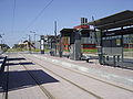
University stop

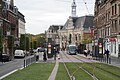
City hall stop and her "hat"

Tram in front of the train station
A tram passes through Hérin

Terminal of the T1 line in Denain: Espace Villars is a junction, the buses stop alongside the platforms


The project and its costs
The participants in the project were:
- Client: the responsible body SITURV
- Delegated developer: Transvilles
- General contractor: Groupement d'ingénierie du Valenciennois (Contractor: INGÉROP)
In July 2001, the public benefit of the new tram project was determined. The groundbreaking for its construction took place in summer 2003 with preparatory work (e.g. laying the drainage channels and other lines), and in June 2004 work began on the construction of the tram depot in Saint-Waast . The first track was laid on September 7, 2004. The route was handed over on June 16, 2006 in the presence of Jean-Louis Borloo , then Minister for Labor and Housing and President of the Valenciennes Region Local Authority.
The first construction phase of Line 1 cost 242.75 million euros, the one with a bond, with own funds from SITURV, a state grant of 41.5 million euros (17% of the project) and a contribution from the European Union of 5.08 Million euros have been generated. The design of the line has received several awards: It received the TCSP Prize of the Year from Villes et Transports magazine and the Prix Janus de la Cité awarded by the French Institute for Design .
The stops of the T1 line
| bus stop | Coordinates | local community | Notes and connections | |||
|---|---|---|---|---|---|---|
| Université 1 (University) | 50 ° 19 ′ 12 " N , 3 ° 30 ′ 45" E | Famars | Park and Ride, 103, 104, 333, 420 | |||
| Moriamez research 1 | 50 ° 19 ′ 29 " N , 3 ° 30 ′ 51" E | Famars | ||||
| Campus Mont Houy 1 | 50 ° 19 ′ 43 " N , 3 ° 30 ′ 53" E | Aulnoy-lez-Valenciennes | Central platform | |||
| Chemin Vert 1 | 50 ° 19 ′ 53 " N , 3 ° 30 ′ 49" E | Aulnoy-lez-Valenciennes | S2, 104 | |||
| Jules Chevalier 1 | 50 ° 20 ′ 2 ″ N , 3 ° 31 ′ 6 ″ E | Aulnoy-lez-Valenciennes | ||||
| La Briquette 1 | 50 ° 20 '24 " N , 3 ° 31' 15" E | Marlys | ||||
| Vosges 1 | 50 ° 20 ′ 31 ″ N , 3 ° 31 ′ 2 ″ E | Valenciennes | Central platform, S1 | |||
| Nungesser 1 | 50 ° 20'55 " N , 3 ° 31'9" E | Valenciennes | Park and ride | |||
| Sainte Catherine 1 | 50 ° 21 ′ 5 ″ N , 3 ° 31 ′ 1 ″ E | Valenciennes | 110 | |||
| Porte de Paris 1 | 50 ° 21 ′ 12 ″ N , 3 ° 31 ′ 1 ″ E | Valenciennes | 110 | |||
| Sous-Préfecture 1 | 50 ° 21 '22 " N , 3 ° 31' 11" E | Valenciennes | ||||
| Hotel de Ville 1 (town hall) | 50 ° 21 ′ 29 ″ N , 3 ° 31 ′ 20 ″ E | Valenciennes | staggered side platforms | |||
| Clemenceau 2 | 50 ° 21 ′ 39 " N , 3 ° 31 ′ 13" E | Valenciennes | Terminal stop of line T2 | |||
| Gare 2 (train station) | 50 ° 21 '50 " N , 3 ° 31' 5" E | Valenciennes | TER, TGV, S1, 1, 5, 6, 30, 100, 103, 131, 401, 403, 450 | |||
| Pont Jacob 2 | 50 ° 21 '57 " N , 3 ° 30' 51" E | Valenciennes | Central platform | |||
| Croix d'Anzin | 50 ° 22 ′ 2 " N , 3 ° 30 ′ 29" E | Anzin | 14th | |||
| Anzin Hotel de Ville | 50 ° 22 ′ 7 " N , 3 ° 30 ′ 7" E | Anzin | Park-and-Ride, S2, 2, 12, 13 | |||
| Saint Waast | 50 ° 21 ′ 49 ″ N , 3 ° 29 ′ 30 ″ E | Valenciennes | Park-and-Ride 1, 2, H (shuttle bus to the hospital) | |||
| La Plaine | 50 ° 21 ′ 39 " N , 3 ° 29 ′ 18" E | Valenciennes | ||||
| Dutemple | 50 ° 21 '25 " N , 3 ° 28' 50" E | Valenciennes | temporarily intermediate terminal | |||
| Bois des Montagnes | 50 ° 21 ′ 21 ″ N , 3 ° 28 ′ 18 ″ E | La Sentinelle | ||||
| Le Galibot | 50 ° 21 ′ 11 " N , 3 ° 27 ′ 8" E | Herin | 102, 110, A (shuttle bus to the airport) | |||
| Les Grémonts | Herin | planned stop | ||||
| As long as Tonini | 50 ° 20 ′ 23 " N , 3 ° 24 ′ 46" E | Denain | ||||
| Bellevue | 50 ° 20 ′ 10 " N , 3 ° 24 ′ 10" E | Denain | Park and Ride, 107 | |||
| Jaurès | 50 ° 19 ′ 55 ″ N , 3 ° 23 ′ 31 ″ E | Denain | 106, 111, 211, TER at Denain train station (380 m) | |||
| Taffy | 50 ° 19 ′ 46 " N , 3 ° 23 ′ 10" E | Denain | 111 | |||
| Jean Dulieu | 50 ° 19 '36 " N , 3 ° 23' 8" E | Denain | 3, 4, 101, 105 | |||
| Espace Villars | 50 ° 19 ′ 34 " N , 3 ° 23 ′ 34" E | Denain | 3, 4, 30, 101, 104, 105, 106, 107, 111, 211, 334 |
1 to October 21, 2018 also line T2
2 also line T2

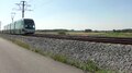
Returning train after the final stop Espace Villars in Denain

Solange Tonini stop, shortly after its inauguration in September 2008
Gare station in Valenciennes, with the station building in the background

Porte de Paris stop

The canteen on the Valenciennes University campus at the Moriamez Recherche stop


The infrastructure


In the sections from the university to the exit of Dutemple and from Taffin to Espace Villars, the standard-gauge track consists of 41 GPU grooved rails , supplied by Corus , which were founded in a concrete slab cast on site. Outside of the road crossings, the track is often planted with lawn. In the section Dutemple-Taffin were catenaries installed in the rest of the network, there are simple contact lines . Between Dutemple and Taffin, the route has the character of a light rail with Vignole rails on a ballasted track and power supply through overhead lines and feeder lines. Two sections of the T1 line use the embankment of the old line from Somain to Péruwelz of the Compagnie des mines d'Anzin railway network : between the Anzin Hôtel de Ville and Dutemple stations and in the second construction phase over 6.5 kilometers.
The construction of the line required the construction of new buildings or the renovation of several high-rise structures, such as the bridge over the motorway A2 and the one under the motorway A23 , the Pont Jacob bridge over the railway line from Douai to Blanc-Misseron and the Escaut river (Schelde), the Sainte-Catherine viaduct (on the old Valenciennes – Faubourg-de-Paris– Hautmont railway line ) and the Pompidou viaduct and the bridge via the Fives - Hirson route .
The majority of the stops have side platforms. However, three stops in a cramped location are equipped with a central platform, including Pont Jacob. Two stops have a sweeping track (at a certain distance from the stop) that allows a train to be parked or to drive parts of it: Anzin Hôtel de Ville and Dutemple. The depot is located near the Saint-Waast station and is accessible from both directions using switches.
The signaling is carried out by classic tram signals. The shunting signals are similar to traffic lights, but in the form of a T, which indicates that they belong to the tram (Tramway). In the inner-city sections, the intersections are protected either by a traditional three-color traffic light or by a red flashing light that switches on when a tram approaches. On the overland sections, the crossings are generally protected by level crossings with gates, the barriers of which close when a tram approaches.

Train on the return track of the end station Espace Villars, red protection stop signal at the end of the siding

The Saint-Waast stop preserves the memory of the old railway line from Somain to Péruwelz, with the old signal and the wall of a freight hall

Signal protecting an intersection: it shows stop (luminous horizontal line), but the system has detected the approach of a tram (luminous yellow diamond)

The Valenciennes tram uses color signals (green and red) with an illuminated T as shunting signals - here you can see the signals that secure the siding of the Anzin Hôtel de Ville stop

Terminus Université with sweeping track (left) and siding


1st construction phase

The first construction phase of line T1 of the tram (Université – Dutemple, 19 stops) was put into operation on July 3, 2006 as line 1. With an initial length of 9.5 kilometers, it crossed five municipalities in the greater area and connected Valenciennes city center with outlying districts that were included in the national urban redevelopment program. In this first phase it created a quick connection between the university and the Gare junction (Valenciennes train station) via the city center.
2nd construction phase

On August 31, 2007, the extension of line 1 of the tram from Dutemple to Denain (Espace Villars) was officially opened with seven new stations, the scheduled service began three days later. This section is 8.8 kilometers long. The cost of the second construction phase was 69 million euros.
Denain as the second pole of the Valenciennes area confirmed his will to improve the traffic conditions in his settlement area. The city wanted to integrate local public transport and private transport into one overall transport plan.
Line 1 development
An eighth stop of the 2nd construction phase, Solange Tonini, was opened in September 2008 to connect the Route d' Oisy and the houses of the Papillons Blancs (home for the disabled) in Denain. The Allende stop was renamed Jean Dulieu on this occasion. On July 3, 2009, the La Plaine stop in the urban area of Valenciennes, located at Rue Saint-Éloi between Saint-Waast and Dutemple, went into operation. Another additional stopover is planned for a later date: Les Grémonts in the municipality of Hérin .
In 2010 the operation of the Transville network was outsourced to Veolia Transport . The new operator restructured the line network, with line 1 being renamed line A. Its graphical representation has also been changed: instead of being red, it was now shown in green, like all lines that run every 10 minutes. The second tram line, previously planned as line 2, was given the designations C and D in the new letter system for its two branches. The line identifier B was already for the TER line from Valenciennes to Saint-Amand-les-Eaux des TER Nord-Pas-de -Calais , which runs on a section of the railway line from Fives to Hirson.
The number of passengers on Line 1
Nine months after it went into operation in March 2007, the Valenciennes tram carried 22,000 passengers a day on the route of the first construction phase. After the entire route went into operation, the number of passengers rose to 29,000 people per day in August 2007.
Lines C and D
The planned lines C and D were originally referred to together as line 2, their planned route length was 32 kilometers. In the north-east of the greater Valenciennes area, the route was to begin in the form of a V in the municipality of Vieux-Condé , via Condé-sur-l'Escaut , Fresnes-sur-Escaut , Escautpont , Bruay-sur-l'Escaut , Anzin to Valenciennes and then run towards Belgium via Saint-Saulve , Onnaing , Quarouble , Quiévrechain to Crespin .
Originally, Quiévrain train station in Belgium was considered as the terminus, but according to more recent plans this would only be reached by a shuttle bus from the tram terminus at Crespin train station. At Quiévrain station, served by the SNCB ICF line, passengers could have continued their journey to Mons and the other stations in Belgium. Unfortunately, potential passengers are put off by the two changes between Valenciennes and Hainaut in Belgium . Today most of the traffic is on busy roads, especially the A2 / A7 motorways.
This explains why the two lines are presented by the SITURV as an element of a cross-border transport offer that connects Valenciennes, but also the south of the northern department (in particular Douai and Cambrai ) with the Belgian cities of Brussels and Charleroi . However, this would require the introduction of modes of transport that influence the modal split in favor of local public transport.
Tram line D would take the place of the reopening of the Douai-Blanc-Misseron railway line on the Valenciennes – state border section. Since 1964, this railway line has only been used on the Belgian section. As part of the State-Region contract 2007-2013, 58 million euros were earmarked for the reopening of the railway line. This objective was abandoned by Jean-Louis Borloo, then Minister for the Environment, and the funds were redeployed for the construction of line D of the Valenciennes tram.
Lines C and D were also planned to be implemented in two phases.
3rd construction phase


The route on line C to Vieux-Condé, which branches off from the T1 route at the intersection of avenue Saint-Armand and avenue de Condé in Valenciennes, is also known as the tram des Pays de Condé. It was mostly single-track with double-track islands and switches at some stations, is 13 kilometers long and crosses seven municipalities. 20 stops are served. The official commissioning took place on December 13, 2013, but passenger service only started on February 24, 2014.
In accordance with Veolia's system, the new line was assigned the line designation B, and now it bears the name T2. Like the T1 line, it began at its south-eastern terminus, Université, and increased its frequency to the Pont Jacob stop. However, the different basic cycles (T1 every 10 minutes, T2 every 12 minutes) led to an unfavorable distribution of journeys on the common section. Since October 22, 2018, the Clemenceau station in the city center of Valenciennes has been its southern end point, behind which the T2 trains turn on a track change.
Development of the project
The participation of citizens and interested parties in view of the drafting of the plan began in early 2007. The project presented was to a single-track tram line 13 to 14 kilometers in length along the department road to realize D 935A to an estimated cost of about 70 to 90 million euros (only for route and material, without costs for the redesign of the street space "from facade to facade"). However, the budget for the project could not be finalized and around ten million euros were not raised. In 2008 the cost of the project was estimated at 188 million euros, which also included the redesign of the street space "from facade to facade" and the renovation of the Bleuse-Borne railway bridge under the contractor of RFF .
In 2008/2009, SITURV considered the construction of line C as a trolleybus on its own route with optical lane guidance (with 130 passengers per vehicle) under the name "Valway". The cost of the trolleybus should be 120 to 150 million euros for lines C and D, that is, the budget would have been reduced by 30% compared to a classic tram. On April 30, 2009, the state announced that it would subsidize the project with 25.3 million euros in view of commissioning at the beginning of 2011. As for the tram solution, the planned own route would have been laid out in a single lane with a width of four meters, and the vehicles would have come together at the stops. The following schedule was established at that time:

- June 2009: Final draft plan accepted
- November 2009: Assessment of the public benefit
- Beginning of 2010: work began
- September 2011: commissioning
The Valway solution was abandoned and on January 18, 2010, the President of SITURV, Francis Decourrière, announced the return to the tram solution, on a single-track route with diversion at the stops. This made it necessary to build a new bridge over the railway facilities at the Fosse de la Bleuse Borne mine in Anzin.
List of new stops

-
Anzin parish
- André Parent
- Center de Congrès
- Les Terrils d'Anzin
- Bleuse Borne
-
Bruay-sur-l'Escaut commune
- Pont de Bruay
- Ruelles
- Bruay Place
- Fruitier
- Les Hauts Champs
- Thiers
-
Escautpont municipality
- Brunehaut
- Salle Polyvalente
- Escautpont Place
-
Fresnes-sur-Escaut parish
- Fresnes Mairie
- Carnot
-
Municipality of Condé-sur-l'Escaut
- Condé Hotel de ville
- Tourniquet
- Hameau de Macou
- Lycée du Pays de Condé
-
Vieux-Condé municipality
- Le Boulon

Pont Jacob stop with central platform, the last station before line 2 leaves the main line

The single-track station Thiers is located at the northern end of a double-track island

Les Hauts Champs station in a single-track section: central platform and siding

Double track island in Fresnes-sur-Escaut
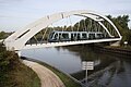
A former railway bridge is used across the Scheldt (Escaut) near Condé-sur-l'Escaut parallel to the road
.JPG)


4th construction phase

The extension of the second line of the tram from Valenciennes to Crespin, planned as an alternative to the reopening of the railway line from Douai to Blanc-Misseron (called line 97 in Belgium), is to be built later. At the beginning of the planning it was supposed to reach Quiévrain, but the efforts to build a cross-border tram were abandoned.
With a length of 12.5 kilometers, this connection, starting from a branch from the main route at the Place du Marché aux Herbes, is to cross Valenciennes on a route to be defined to the Place Poterne. Thereafter, it should lead largely single-track through Saint-Saulve, Onnaing, Quarouble and Quiévrechain to Crespin. For the most part, it should follow the former national road 30 to the entrance to Onnaing, then branch off to reach the Crespin train station on the route of the old international railway line Valenciennes – Mons.
When this extension goes into operation, lines C and D should be combined in a single line T2 from Vieux-Condé via Valenciennes to Crespin, which in Valenciennes would share a section with line T1. In the meantime, there is talk of abandoning the construction of the line to Crespin and replacing it with a bus route.
Construction of lines C and D (aka line 2)
At the beginning of July 2011, the public benefit was determined for phase III. The SITURV does not use the terms line C and D, one speaks simply of line 2, which on the other hand is always divided into phases III and IV. The construction of phase III began with the road works and the works on the own route with a symbolic act: the laying of the first rail in Condé-sur-l'Escaut on September 16, 2011.
The costs of phase III amounted to EUR 103 million, those of phase IV to EUR 52 million, so the total costs of line 2 are estimated at EUR 155 million. The state contributed to the construction costs through the following grants: 25.3 million euros from the financing agency for transport infrastructure and 21 million euros under the state-region contract.
Planning
Depending on the demographic and economic situation of the region and the conceivable development hypotheses, the following extensions of the tram network can be considered:
- Extension from Valenciennes to Marly (town hall) towards Saultain (Les Dix Muids). This extension could go through avenue Henri Barbusse or avenue Jean Jaurès.
- Extension from Denain to Douchy-les-Mines : the Espace Villars terminus of the T1 line in Denain already points towards the municipality of Douchy-les-Mines.
- Extension from Anzin to Raismes : this extension would be possible through avenue Anatole-France to Place de Raismes.
- Extension from Crespin to Quiévrain: this extension would follow the old railway line.
Vehicle fleet


21 Alstom Citadis type 302 railcars were acquired for the Valenciennes tram . They consist of five car bodies that rest on three bogies and are 33 meters long in their basic version. The car width is 2.40 meters. The vehicles each have a motor bogie at the ends of the vehicle, and a non-powered running bogie is located under the middle car body .
The floor is low-floor along the entire length of the car, it is only raised under the seats in the area of the wheels. The "Arpège" bogies have cranked axles to simplify the passage of the low-floor floor between the wheels. The drive motors are attached to the outside of the wheels. There is one motor per wheel, i.e. eight motors for the two motor bogies. These bogies have a small spring deflection (approximately 11 centimeters), which limits the space required by the wheels in the car body.
The 750 volt DC power supply is provided by a single-arm pantograph in the middle of the vehicle. The trams use Alstom's ONIX drive system , with direct current supplying the drive motors via IGBT inverters. All electrical equipment is located on the roof of the vehicles. This structure enables a low vehicle floor and ensures good cooling of the components of the traction system.
Each train can carry up to 295 people, it has 48 seats and runs at an average speed of 30 km / h. SITURV chose And Partenaires to design the head shape and the interior of the trolleys. The selection of the exterior paintwork and the interior color scheme were based on the architecture and climate of Valenciennes.
The vehicles are serviced in a depot with an area of 14,500 m 2 , which is located near the Saint-Waast stop. It has ten storage and seven maintenance tracks and was designed by the architect Jacques Ferrier and the SETEC office. The control center for tram operations is also located there. The maintenance of the wagons is carried out by the manufacturer Alstom.
Change of operator on January 1st, 2015
Since January 1st, 2015, the Valenciennes public transport has been operated by RATP Dev , the contract runs for seven years. In this context, line A was renamed T1 and line B was renamed T2. Competitors in the tender were Keolis and Vectalia, the latter works for the public transport system in Barcelona . The services of the RATP are remunerated with 35 million euros per year (the previous operator received almost 40 million euros). The transport offer has been streamlined and the tariff structure has also been changed. In addition, there are 15 million from ticket sales. If this income is higher than 15 million, the surplus is divided equally between RATP and the client.
Remarks
- ↑ TCSP: Transports collectifs en site propre = public transport on a separate track
- ↑ T stands for Tramway (tram)
See also
Web links
- Tram in France - Valenciennes
- Transvilles website with network map
- Homepage of the client Syndicat Intercommunal pour les Transports Urbains de la Région de Valenciennes (SITURV)
- Le tram. Une nouvelle ligne de vie (Presentation of line 2; French)
literature
- Christoph Groneck: French planning models for tram systems compared to Germany . Dissertation, University of Wuppertal, 2007. (PDF; 5.4 MB)
- Harald A. Jahn: The future of cities . Phoibos Verlag, Vienna 2010, ISBN 978-3-85161-039-0 .
- Jean-Claude Vaudois: Valenciennes aujourd'hui: Où l'histoire est un éternel recommencement. In: Chemins de Fer régionaux et Tramways. Vol. 2006-5, No. 317, ISSN 1141-7447 , pp. 12-15.
- Ammar Triche, Stéphane Potin, Gérard Gilliocq: Le tramway de Valenciennes. In: Travaux. June 2007, No. 842, ISSN 0041-1906 , pp. 28-41.
- Jean Tricoire: Le tramway en France. La Vie du rail, 2007, ISBN 978-2-915034-73-8 .
- Jacques Tanche: Renaissance d'un tramway. Punch Editions, 2006, ISBN 2-913132-84-7 .
- Maël Desse-Engrand: What mode of transport en commun en site propre pour la transfrontalière line entre Valenciennes et Quiévrain? In: Transports urbains. December 2009, No. 116, ISSN 0397-6521 , pp. 9-14.
Individual evidence
- ↑ a b c d Christoph Groneck, Robert Schwandl: Tram Atlas France . 1st edition. Robert Schwandl, Berlin 2014, ISBN 978-3-936573-42-8 , pp. 156 ff .
- ↑ FACS: Les Chemins de Fer Secondaires de France: le département du Nord ( Memento of March 11, 2014 in the Internet Archive )
- ↑ a b c ciphers clés . Transvilles. Archived from the original on February 9, 2010. Retrieved October 20, 2013.
- ↑ Un siècle de transports publics dans le Valenciennois, ed. von Semurval, ISBN 2-904513-00-0 available online: PDF ( Memento of December 10, 2015 in the Internet Archive )
- ↑ a b Maël Desse-Engrand, see bibliography
- ↑ Renaissance d'un tramway, see bibliography
- ↑ a b c d e f Jean Tricoire, le tramway en France
- ↑ a b Un tram, une ville: Retour vers le futur pour le tramway de Valenciennes . Alstom. 2007. Archived from the original on April 6, 2010. Retrieved October 20, 2013.
- ↑ Le tram de Valenciennes, in: ACTP Info, ed: Association des Clients des Transports Publics - asbl, October-December 2006, Liège PDF
- ↑ SETEC TPI: Tramway de Valenciennes: Audits ( Memento of December 7, 2008 in the Internet Archive ) (PDF; 638 kB)
- ↑ Une nouvelle Ligne de vie ( Memento of December 3, 2008 in the Internet Archive )
- ↑ http://www.nord.pref.gouv.fr/images/actualites/070621_ip_csuiv_objectif1_siturv.pdf (Link not available) Invitation press: Comité de suivi du Program européen objectif 1: visite du tramway de Valenciennes et de ses abords
- ↑ Le rail 41 GPU de Corus équipera le tramway de Valenciennes
- ↑ a b Tramway de Valenciennes
- ↑ Abscon - Saint-Waast-la-Haut, section de la Linie Somain - Péruwelz
- ^ François Enver: Tramway - Valenciennes: Veolia imprime sa marque. In: Ville, rail & transports. September 8, 2010, No. 502, ISSN 2104-0028 , p. 14.
- ↑ a b Un tram, une ville: Le réseau de Valenciennes aujourd'hui . Alstom. 2007. Archived from the original on April 6, 2010. Retrieved October 20, 2013.
- ↑ You nouveau entre Dutemple et Denain
- ↑ Descriptif de la Ligne (PDF; 8.6 MB)
- ↑ a b Tramway Phase IV (Line D)
- ↑ Tram ligne 2: Changement du Terminus et ajout de bus at valenciennes.fr, accessed on November 8, 2018
- ↑ Stéphane Potin: Concevoir des transports innovants: le TramOneWay. In: Les cahiers de l'ingénierie de projet. November 2007, No. 74, p. 21. Concevoir des transports innovants (PDF) Archived from the original on April 1, 2010. Retrieved on October 20, 2013.
- ↑ Philippe Hautcœur: Phase III du Tramway
- ^ François Gérin: La phase III, de Valenciennes à Vieux-Condé, est presque sur les rails définitifs
- ↑ Bernard DEFONTAINE: Un tramway non plus sur rail, mais sur pneus pour la Line 2: Valway! in: La Voix du Nord, édition de Valenciennes, October 10, 2008 [1]
- ↑ Francis Decourrière: Le choix du tramway sur pneus dans le Valenciennois, 24. October 2008
- ↑ Philippe Hautcœur: 25 millions d'euros pour le Valway
- ↑ Abandon du projet Valway
- ^ Conseil régional Nord-Pas-de-Calais: Commission permanente du 2 juillet 2007: La future Linie IV du tramway de Valenciennes vers la Belgique, July 3, 2007 ( Memento of June 30, 2008 in the Internet Archive )
- ↑ Phase IV du tramway valenciennois: Valenciennes - Crespin (Line D)
- ↑ Groupement belge pour la promotion et l'exploitation touristique du transport ferroviaire: Le retour du "tramway vicinal" à Quiévrain (comprenant des plans de l'implantation du projet entre la frontière belge et la gare de Quiévrain)
- ^ A b La Voix du Nord: Feu vert pour la phase 3 du tram de Valenciennes à Vieux-Condé, 25 July 2011
- ↑ Valenciennes: Linking up for a change ( Memento from January 16, 2013 in the web archive archive.today )
- ↑ Mobilicietés: Valenciennes: RATP dev prend les commandes pour sept ans of November 18, 2014, accessed on February 26, 2015
Trams:
Angers |
Aubagne |
Avignon |
Besançon |
Bordeaux |
Brest |
Caen |
Dijon |
Grenoble |
Le Havre |
Le Mans |
Lille |
Lyon |
Marseille |
Montpellier |
Mulhouse |
Nantes |
Nice |
Orléans |
Paris (Île-de-France) |
Reims |
Rouen |
Saint-Etienne |
Saint-Louis (Haut-Rhin) (Basel) |
Strasbourg |
Toulouse |
Tours |
Valenciennes