Tiefenbach (near Passau)
| coat of arms | Germany map | |
|---|---|---|

|
Coordinates: 48 ° 37 ' N , 13 ° 24' E |
|
| Basic data | ||
| State : | Bavaria | |
| Administrative region : | Lower Bavaria | |
| County : | Passau | |
| Height : | 373 m above sea level NHN | |
| Area : | 49.72 km 2 | |
| Residents: | 6772 (Dec. 31, 2019) | |
| Population density : | 136 inhabitants per km 2 | |
| Postal code : | 94113 | |
| Primaries : | 08509, 0851 , 08546 | |
| License plate : | PA | |
| Community key : | 09 2 75 151 | |
| LOCODE : | DE TCV | |
| Community structure: | 78 districts | |
| Address of the municipal administration: |
Pilgrim Street 2 94113 Tiefenbach |
|
| Website : | ||
| Mayor : | Christian Fürst ( CSU ) | |
| Location of the community of Tiefenbach in the district of Passau | ||
Tiefenbach is a municipality in the Lower Bavarian district of Passau .
geography
Geographical location
Tiefenbach is located in the Danube Forest region, in one of the southernmost foothills of the Bavarian Forest, northwest of the Ilz and north of the Danube on the B 85 . Tiefenbach is only 9 km north of the university and three-river city of Passau . After Tittling is 15 km until Grafenau 32 km and Bundesautobahn 3 (exit Passau-Nord) 7 km.
Neighboring communities
Community structure
The community of Tiefenbach has 78 districts:
There are the districts Haselbach, Kirchberg and Tiefenbach.
history
Until the church is planted
Tiefenbach was owned early on by the bishops of Passau, who left it to the Counts of Hals and other noble families as fiefs . The Sünzl von Söldenau family had been enfeoffed with the Hofmark Tiefenbach since 1613 and resided at Weideneck Castle near Tiefenbach. Until the Hofmark was sold by Jakob Ferdinand Graf von Thun to the Bishop of Passau in 1690, Tiefenbach was now part of the Passau Monastery . With the Reichsdeputationshauptschluss of 1803, the place came to Bavaria. Tiefenbach was one of the few parts of the Hochstift that fell to Bavaria in 1803. In 1818 the political municipality was established.
19th century
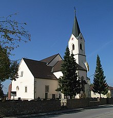
Since the old church was dilapidated, the present church was built between 1842 and 1844 and was opened on October 12, 1848 in honor of St. Dedicated to Margaretha. In 1855 the village had 16 houses in addition to the parish church.
Incorporations
Haselbach, Kirchberg and Tiefenbach were independent communities from 1818 to 1971/1972. On January 1, 1972, Haselbach was incorporated into the municipality of Tiefenbach. The greater part of the Kirchberg community was added on July 1, 1972. The rest of the Kirchberg community with the Schalding district to the left of the Danube and the hamlet of Minihof (formerly Mimming) was incorporated into the city of Passau and added to the newly formed Hacklberg district.
Population development
In the period from 1988 to 2018, the municipality grew from 5,701 to 6,772 by 1,071 inhabitants or 18.8%.
- 1961: 3961 inhabitants
- 1970: 4512 inhabitants
- 1987: 5930 inhabitants
- 1991: 6223 inhabitants
- 1995: 6525 inhabitants
- 2000: 6725 inhabitants
- 2005: 6694 inhabitants
- 2010: 6683 inhabitants
- 2015: 6713 inhabitants
- 2017: 6768 inhabitants
- 2018: 6772 inhabitants
politics
Municipal council
The 2020 local election resulted in the following result for the local council (change compared to 2014 in brackets):
- CSU : 32.8% (–9.1) - 7 seats (–1)
- FWG : 16.2% (-2.9) - 3 seats (-1)
- Bourgeois voters Tiefenbach : 14.4% (+0.1) - 3 seats (± 0)
- Greens : 13.1% (+3.0) - 3 seats (+1)
- SPD : 11.3% (-3.3) - 2 seats (-1)
- Our future - think with us! Take part! : 12.2% (new) - 2 seats (new)
mayor
The first mayor was Georg Silbereisen (CSU), who was elected in the 2008 local elections with 65.32% of the valid votes in the first ballot.
After Georg Silbereisen (CSU) resigned as First Mayor for health reasons, the new election took place on October 28, 2018, Christian Fürst (CSU) won the mayor election with just 53.52% ahead of his opponent Walter Wagner (independent).
Culture and sights
- Haselbach Castle is located in Haselbach .
- Jackinger Linde in Oberjacking . It had to be felled in February / March 2015.
Economy and Infrastructure
Economy including agriculture and forestry
In 2017 there were a total of 1,363 employees subject to social security contributions at the place of work. There were 2,867 employees subject to social security contributions who lived in Tiefenbach. This meant that the community had 1504 more outbound than inbound commuters. 81 residents were unemployed.
In 2016 there were 86 farms. On December 31, 2017, according to the official area survey, 2,373 hectares (47.7%) of the municipal area were used for agriculture, 1,751 hectares (35.2%) were forest. The settlement area was 419 hectares (8.4%), 277 hectares (5.6%) were used for traffic.
traffic
The most important road in the village is federal highway 85 from Regen to Passau .
From 1890 to 1982 there was a stop on the Passau – Freyung railway line for the Unterjacking district . After that it was only served by special trips until 2002. Since July 16, 2011, this stop has been served again on Saturdays, Sundays and public holidays in the summer as part of the Danube-Moldau leisure traffic project, and all year round for special trips.
education
There are the following facilities
- 3 kindergartens: 207 kindergarten places with 173 children, 29 of them under three years of age (as of 2014)
- 2 primary schools and 1 middle school: 34 teachers and 394 students (as of 2018/2019)
Personalities
The folk music TV presenter Florian Silbereisen was born on August 4, 1981 in Tiefenbach.
Individual evidence
- ↑ "Data 2" sheet, Statistical Report A1200C 202041 Population of the municipalities, districts and administrative districts 1st quarter 2020 (population based on the 2011 census) ( help ).
- ^ Community Tiefenbach in the local database of the Bayerische Landesbibliothek Online . Bayerische Staatsbibliothek, accessed on January 5, 2018.
- ^ Wilhelm Volkert (ed.): Handbook of Bavarian offices, communities and courts 1799–1980 . CH Beck, Munich 1983, ISBN 3-406-09669-7 .
- ↑ Result of the 2020 municipal council election , at www.gemeinde-tiefenbach.de, accessed on May 7, 2020.
- ^ Passauer Neue Presse of March 5, 2015: 800 year old Jackinger linden tree felled
- ↑ Haselbach primary school in the school database of the Bavarian State Ministry for Education and Culture , accessed on August 20, 2019.
- ↑ Alfons-Lindner-Grundschule Tiefenbach in the school database of the Bavarian State Ministry for Education and Culture , accessed on August 20, 2019.
- ↑ Alfons-Lindner-Mittelschule Kirchberg vorm Wald in the school database of the Bavarian State Ministry for Education and Culture , accessed on August 20, 2019.
Web links
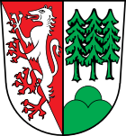
- Entry on the coat of arms of Tiefenbach (near Passau) in the database of the House of Bavarian History


