Walvis Bay
| Borough Walvis Bay Walvisbaai ( af ) Walvis Bay ( de hist.) |
|||
|---|---|---|---|
|
|||
| Aerial view of Walvis Bay with the harbor in the foreground | |||
| motto | In utrumque paratus (equipped for everything) |
||
| Basic data | |||
|
Population Area Population Density |
62,096 ( 2011 census ) 32.5 km² 1910.6 inhabitants / km² |
||
|
State Region Constituency |
Namibia Erongo Walvis Bay City |
||
| Establishment date | around 1840 (1931) | ||
|
License plate phone code |
WB 64 |
||
| Website | walvisbaycc.org.na | ||
|
Political data
Mayor : Uillika Nambahu ( SWAPO ) Chief Executive Officer : Muronga Haingura (SWAPO) Last election: 2015 Next election: 2020 City Council address: |
|||
|
Geographical data
|
|||
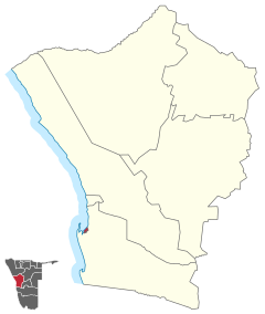
Walvis Bay (German historically Walvis Bay , rare Walfishbay or Walvis Bay ; Afrikaans : Walvisbaai , Otjiherero : Ezorongondo ) is a town on the Walvis Bay in Namibia Region Erongo and the most important seaport of Namibia . The city limits correspond to those of the Walvis Bay City constituency .
Walvis Bay has 62,096 inhabitants (as of 2011) on an area of 32.5 square kilometers . It is the third largest city in the country and with a population density of 1889.1 inhabitants per km² by far the most densely populated.
geography
location
Walvis Bay is located on the Atlantic coast around 30 kilometers south of the city of Swakopmund . This is the end point of the B2 national road .
climate
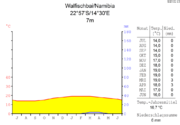
The pleasantly mild coastal climate makes the city and its surroundings a popular destination in the South Atlantic , especially during the months of October to March , even if the water temperature hardly rises above 20 ° C as a result of the cold Benguela Current coming from the Antarctic .
|
Monthly average temperatures and rainfall for Swakopmund / Walvis Bay
Source:
|
|||||||||||||||||||||||||||||||||||||||||||||||||||||||||||||||||||||||||||||||||||||||||||||||||||||||||||||||||||||||||||||||||||||||||||||||||||||||||||||||||||||
history

Between 1482 and 1489, the Portuguese navigator Diogo Cão explored the west coast of Africa and also sailed into Walvis Bay. Because of its abundance of whale and fish, the bay has been of interest to European and North American fishermen since the early 18th century and was annexed in 1795 by the crew of the British warship Star . Due to a developing trade with the local Topnaar - a Nama society - the place grew into a larger settlement after 1850. On March 12, 1878, the Walvis Bay with a surrounding strip of land was taken over for the British Crown . On the one hand, British fishermen and guano traders from the Penguin Islands had set up a base there; on the other hand, strategic considerations played a role in securing the British sea route to India .
In 1884 the area around the bay became a protected area of the German Empire and Walvis Bay became a British enclave . In 1889, soldiers from the German Schutztruppe under the leadership of Captain Curt von François landed in Walvis Bay because the sandwich port was not available.
In 1910, as part of the Cape Province, the area became part of the newly founded South African Union . In 1914/15 it was briefly under German occupation at the beginning of the First World War . After German South West Africa in 1919 as the League of Nations - mandated territory was placed under South African administration, the place was in 1922 by decision of the Cape Town Parliament administratively the territory of South West Africa assigned. In 1931 Walvis Bay received town charter ; the first mayor of the city was S. Blyth. Until 1977 he was followed by WG Neate, JC Harris, MC Botma and A. Prinsloo.
From the mid-1970s onwards, a transition process emerged that was to lead to Namibia's independence in the long term; In 1977 the "Walvis Bay area" was directly subordinated to the Cape Province , which in fact meant an annexation of the area by South Africa. Contrary to a UN resolution , South Africa still occupied Walvis Bay and the Penguin Islands after Namibia's independence in 1990 . Only after the end of apartheid did the Republic of South Africa hand over both the Walvis Bay area and the Penguin Islands to the Republic of Namibia on March 1, 1994 .
The city has been particularly hard hit by the COVID-19 pandemic in Namibia since June 2020.
Local politics
The following official final result was determined in the 2015 local elections .
| Political party | be right | Share of votes | Seats |
|---|---|---|---|
| SWAPO | 5818 | 81.4% | 8th |
| DTA | 565 | 7.9% | 1 |
| UDF | 433 | 6.1% | 1 |
| RDP | 141 | 1.9% | 0 |
| NUDO | 107 | 1.5% | 0 |
| APP | 81 | 1.1% | 0 |
| All in all | 7145 | 100% | 10 |
Administrative division
Districts or suburbs of Walvis Bay are:

Economy and Transport
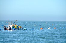
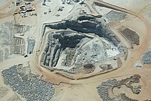
The city's economy is largely based on trade via the Walvis Bay harbor and the fish processing industry. The city is the seat of the Namibian Port Authority and the Walvis Bay Corridor Group ; there is a shipyard , an international airport and a saltworks south of the city . The construction of a second port ( SADC Gateway Port ) has been advanced since 2014.
The Namibian Navy has ships stationed in Walvis Bay. In addition , the Trans-Kalahari Highway , which comes from Mozambique on the Indian Ocean and crosses the entire continent , starts / ends here north of the Kuisebmund Stadium . Other roads are the Trans-Caprivi-Highway , the B2 national road and the main C14 road . For a few years there have been modest beginnings of tourism, prompted and encouraged by the proximity of the city of Swakopmund and by the tours into the surrounding area that are offered from Walvis Bay. Due to the steady, reliable wind, Walvis Bay is well suited for windsurfing and kitesurfing, which is only limited by the relatively cold water of the Benguela Current . The large sandbank in the bay is also a suitable special area for high-speed sailing. You can set courses over the 500 m distance as well as over the nautical mile in shallow water with offshore wind. For this reason, several speedsurfing world cups have already been held on the sandbank of Walvis Bay and records have even been broken temporarily, especially on the nautical mile.

The area of Walvis Bay is 1,124 km². Today around 52,000 people live here - but with great fluctuations, as the fish industry only provides work on a seasonal basis. Walvis Bay International Airport is currently being extensively expanded. The aim of the development is non-stop cargo flights to Europe. There are currently daily flight connections with Air Namibia to Windhoek and via Lüderitz and Oranjemund to Cape Town and with South African Airways to Johannesburg and Cape Town.
The city is connected to the Namibian rail network via the Kranzberg – Walvis Bay railway line.
Educational institutions
There are several elementary and secondary schools in Walvis Bay.
- Duinesig Primary School
- De Duine Secondary School
- Duneside High School
- Immanuel Reuters Primary School
- Kuisebmond Secondary School
- Tutaleni Primary School
- The International School of Walvis Bay, the only international school in the country besides the one in Windhoek
- Walvis Bay Primary School
- Walvis Bay Private High School
Tertiary educational institution in Walvis Bay is the Namibian Maritime and Fisheries Institute , which serves to train engineers and captains . The private, state-recognized International University of Management also maintains a campus in Walvis Bay.
Attractions
In the city
- The Rhenish Mission Church , at the corner of 5th Street and Hage Geingob Street, is a National Monument in Namibia and is considered the oldest historical building in Walvis Bay.
- Hope locomotive at the train station on 5th Street.
Excursion destinations in the area
Walvis Bay offers a number of tours, some of which you can also drive to the destinations yourself. This includes:
- The lagoon ; it is located on the southern edge of the city, is over 5000 years old and thus the oldest in Namibia and an internationally known bird sanctuary with the most important mudflat area in southern Africa. It offers protection for up to 160,000 birds and food for over 200,000 terns as they migrate to and from the Antarctic regions. The lagoon is essential for about 70% of all plover plovers ( Charadrius pallidus ) in the world . Over 80% of all flamingos in southern Africa feed on this lagoon. You can paddle through the lagoon in a kayak .
- Bird Island guano platform ; it is nine kilometers north of Walvis Bay in the sea. It is the only place in Namibia, where the white pelican ( Pelicanus onocrotalus ) breeds. The platform is also a popular seat for white-breasted cormorants ( Phalacrocorax lucidus ) and crown shags ( Microcarbo coronatus ).
- Robben - and dolphin tours with boats along the coast
- Deep sea fishing
- Excursions by boat or four-wheel drive to the bird colonies of Sandwich Harbor , a 10 km long lagoon; On the way there you will pass the stone cross ( Padrão ) that was once set by Portuguese sailors , which heralds the landings and occupation of Portugal. It can be found on a small bay about 20 km south of Walvis Bay.
- Drive with four-wheel drive vehicles to the Kuiseb Delta south of the lagoon
- Visit to the Gobabeb desert research station at Kuiseb, 80 km away
Town twinning
|
|
Domestic cooperation agreements exist with Swakopmund , Tsumeb and Windhoek .
Source: Walvis Bay City Council
sons and daughters of the town
- Otto Herrigel (1937–2013), lawyer, businessman and politician
- Ben Amathila (* 1938), politician, former minister and freedom fighter
- Niko Bessinger (1948–2008), architect and politician
- Neshani Andreas (1964–2011), writer and teacher
- Harry Simon (* 1972), professional boxer
- Percy Montgomery (* 1974), South African rugby union player
- Rudolf Bester (* 1983), football player
- Johanna Benson (* 1990), Paralympic athlete and gold medalist at the 2012 Summer Paralympics
literature
- Melinda Silverman: Between the Atlantic and the Namib. An Environmental History of Walvis Bay . Namibia Scientific Society (NWG), Windhoek 2004.
- Charles de Beer: Namibia Marine Life . @tidude Graphix, Swakopmund o. J.
- Andreas Vogt: National Monuments in Namibia . Gamsberg Macmillan, Windhoek 2006.
Web links
Individual evidence
- ↑ 2011 Population and Housing Census, Erongo Regional Profile. Namibia Statistics Agency, 2014, p. Ii
- ↑ Namibia 2011 Population and Housing Census Preliminary Results. Namibia Statistics Agency, April 2012, accessed May 9, 2012
- ↑ MSN Weather Swakopmund, Namibia. MSN Weather, accessed September 10, 2009 .
- ↑ Climate Swakopmund - Namibia. Climatedata.eu, accessed on September 1, 2010 (English).
- ↑ http://www.klausdierks.com/Geschichte/85.htm
- ↑ Local Authorities 2015. The Namibian, December 4, 2015, pp. 6ff
- ↑ - ( Memento of December 2, 2011 in the Internet Archive )
- ^ Official website of The International School of Walvis Bay
- ↑ http://www.wbphs.com/
- ↑ www.wenzhou.gov.cn: City friendships . Retrieved July 11, 2019.
- ↑ Walvis Bay's new twin town in Sweden, AZ, October 15, 2009
- ^ Walvis Bay, Pointe-Noire sign friendship agreement. Namibia Press Agency, October 10, 2019.
- ^ Walvis Bay - Twining Agreements . Retrieved December 12, 2017.
Coordinates: 22 ° 57 ′ S , 14 ° 30 ′ E


