
Mount Lemmon: Difference between revisions
No edit summary |
|||
| (142 intermediate revisions by 82 users not shown) | |||
| Line 1: | Line 1: | ||
{{Short description|Mountain in Arizona, United States}} |
|||
{{refimprove|date=November 2009}} |
|||
{{Use mdy dates|date=February 2014}} |
|||
{{stack|{{Infobox mountain |
|||
{{Infobox mountain |
|||
| name = Mount Lemmon |
|||
| |
| name = Mount Lemmon |
||
| photo = File:View of the Santa Catalina Mountains from West Saguaro National Park near Tuscon, AZ.jpg |
|||
| photo_caption = Backside of Mt. Lemmon |
|||
| |
| photo_size = |
||
| |
| photo_alt = |
||
| photo_caption = View of Mount Lemmon from the western side of |
|||
| prominence_m = |
|||
| elevation_ft = 9171 |
|||
| prominence_ref= |
|||
| elevation_ref = {{navd88}}<ref name="ngs">{{cite ngs |pid=CZ1859 |name=Catalina 2 Reset |access-date=2016-08-18}}</ref> |
|||
| listing = |
|||
| prominence_ft = 5157 |
|||
| location = [[Tucson, Arizona]], {{flag|United States}} |
|||
| prominence_ref = <ref name="pb">{{cite peakbagger |pid=4191 |name=Mount Lemmon, Arizona |access-date=2014-02-07}}</ref> |
|||
| listing = {{unbulleted list |
|||
| [[List of highest points in Arizona by county|Arizona county high point]]<ref>{{cite peakbagger |lid=lid=13211 |name=Arizona County High Points |access-date=2021-11-15}}</ref> |
|||
| [[List of the most prominent summits of the United States|U.S. most prominent peaks]] 117th }} |
|||
| location = [[Tucson, Arizona|Tucson]], [[Pima County, Arizona|Pima County]], [[Arizona|Arizona, U.S.]] |
|||
| range = [[Santa Catalina Mountains]] |
| range = [[Santa Catalina Mountains]] |
||
| map = USA Arizona |
| map = USA Arizona |
||
| map_size = 180 |
|||
| map_caption = none |
|||
| label_position = right |
| label_position = right |
||
| coordinates = {{coord|32.442961983|N|110.788478444|W|type:mountain_region:US-AZ_scale:100000_source:NGS|format=dms|display=inline,title}} |
|||
| map_size = 200 |
|||
| range_coordinates = |
|||
| lat_d = 32.4431311 | long_d = -110.7884295 |
|||
| coordinates_ref = <ref name= |
| coordinates_ref = <ref name="ngs"/> |
||
| topo = |
| topo = [[USGS]] Mount Lemmon |
||
| type = |
| type = |
||
| age = |
| age = |
||
| Line 23: | Line 30: | ||
}} |
}} |
||
'''Mount Lemmon''', with a summit elevation of {{convert|9,159|ft|0}},<ref name="ngs"/> is the highest point in the [[Santa Catalina Mountains]]. It is located in the [[Coronado National Forest]] north of [[Tucson, Arizona]], United States. Mount Lemmon was named for [[botany|botanist]] [[Sara Plummer Lemmon]], who trekked to the top of the mountain with her husband and E. O. Stratton, a local rancher, by horse and foot in 1881.<ref name="calbeat">{{cite web |url=http://www.californiabeat.org/2009/05/27/california-beat-hero-sara-plummer-lemmon |title=California Beat Hero: Sara Plummer Lemmon |date=May 27, 2009 |publisher=CaliforniaBeat.org |access-date=2014-02-07}}</ref><ref>{{cite web |author=Lemmon, J.G. |title=A botanical wedding trip |work=Californian vol. 5. no. 24. |pages=517–525 |year=1881 |url=http://www.nybg.org/files/The_Californian_BotanicalWeddingTrip.pdf |url-status=dead |archive-url=https://web.archive.org/web/20150402092321/http://www.nybg.org/files/The_Californian_BotanicalWeddingTrip.pdf |archive-date=April 2, 2015 |df=mdy-all }}</ref> Mount Lemmon is also known as Babad Do'ag, or Frog Mountain<ref>{{Cite web|date=2015-07-22|title=How did Mt. Lemmon Get Its Name?|url=https://southernarizonaguide.com/how-did-mt-lemmon-get-its-name/|access-date=2021-08-06|website=SouthernArizonaGuide.com|language=en-US}}</ref> to the [[Tohono Oʼodham|Tohono O'odham]]. |
|||
'''Mount Lemmon''' is in the [[Santa Catalina Mountains]] located in the [[Coronado National Forest]] north of [[Tucson, Arizona]], [[United States]]. It is {{convert|9157|ft|m|0}} above sea-level, and receives approximately 180 inches of snow annually. Mount Lemmon was named in honor of [[botany|botanist]] [[Sarah Lemmon]], who trekked to the top of the mountain with Native American guides by mule and foot in [[1881]]. {{Citation needed|date=November 2009}} |
|||
== |
==Geography== |
||
===Climate=== |
|||
[[Summerhaven, Arizona|Summerhaven]] is a small town near the top of the mountain. It is a summer residence for many but there are some year round residents. There are many small cabins most of which are being rebuilt after the Aspen Fire. Much of this town was devastated by the [[Aspen Fire]] of July 2003, and recovery is still taking place.{{Clarify|date=November 2009}} It is near [[Mount Lemmon Ski Valley|Ski Valley]] which is the southernmost ski destination in the continental United States. |
|||
Due to the elevation change from the bottom to the top, the summit of the mountain can be 20–30°F cooler than the base. It usually sees at least one snowfall during the winter months, making it a cool escape and popular tourist attraction for Tucson inhabitants. |
|||
==Geology== |
|||
==Mount Lemmon Station Observatory== |
|||
Mount Lemmon is made up of [[Bolsa Quartzite]], [[Dripping Spring Quartzite]], and a local sandstone and conglomerate. The portions have been intruded by a [[Diabase]] [[Dike (geology)|Dike]] of the [[Apache Group (geology)|Apace Group]].<ref>{{cite book |last1=Bezy |first1=John V. |title=A Guide to the Geology of the Santa Catalina Mountains, Arizona: The Geology and Life Zones of a Madrean Sky Island |date=2016 |publisher=The Arizona Geological Survey |location=Tucson, AZ |isbn=978-0-9854798-2-4 |edition=Down to Earth #22 |url=http://repository.azgs.az.gov/sites/default/files/dlio/files/nid1679/bezy-santacatalina-22-final.pdf |access-date=2 September 2020}}</ref> |
|||
{{main|Mount Lemmon Observatory}} |
|||
At the peak of Mount Lemmon is an astronomical [[observatory]], which was formerly the site of an USAF radar base of the [[Air Defense Command]]{{Citation needed|date=November 2009}}, and the building that formerly housed a military emergency radar tracking station for landing the [[Space Shuttle]] at [[White Sands Missile Range]]. Although the [[United States Military]] had a presence on the mountain for several decades all their facilities have been abandoned and were given to the US [[Forest Service]]. The area and buildings that makes up the Mount Lemmon Station Observatory are leased from the Forest Service by the University of Arizona. The telescopes on the mountain are still used for astronomical research today by organizations such as the [[Catalina Sky Survey]], The [[University of Arizona]] [[Astronomy Camp]] program,<ref>http://www.astronomycamp.org</ref>, the University of Arizona, the [[University of Minnesota]], and the Mount Lemmon Sky Center. The educational resources at the top of the mountain make it a unique research, [[Biology]] and [[Astronomy]], and teaching destination. |
|||
== |
==Summerhaven== |
||
[[File:Summerhaven,_Cookie_Cabin.jpg|thumb|left|Summerhaven, Cookie Cabin]] |
|||
[[Summerhaven, Arizona|Summerhaven]] is a small town near the top of the mountain. It is a summer residence for many, but there are some year-round residents. There are many small cabins, most of which were rebuilt after the [[Aspen Fire]] of July 2003.<ref>{{cite web |last=Faherty |first=John |title=Town of Summerhaven back after devastating fire |url=http://www.azcentral.com/news/articles/2008/06/17/20080617Summerhaven.html |publisher=AZ Central |access-date=2012-08-28}}</ref> |
|||
The location 'Windy Point' was built by the [[Federal Bureau of Prisons]], using a large number of prisoners over a period of 18 years, and is a popular place for outdoor weddings.{{Citation needed|date=November 2009}} |
|||
==Catalina Highway== |
|||
{{Weather box |
|||
The [[Catalina Highway]], also called the Mount Lemmon Highway, as well as the Hitchcock Highway (after [[Frank Harris Hitchcock]]) runs up the Santa Catalina Mountains from the east side of Tucson up to [[Summerhaven, Arizona|Summerhaven]], at the top of Mt. Lemmon. The beautiful, curving road is a favorite drive for tourists, for locals escaping summer's heat, for motorcyclists, and cyclists, and has been recently designated as the ''Sky Island Parkway'', part of the US [[National Scenic Byway]] system.<ref>{{cite web|url=http://www.azdot.gov/highways/SWProjMgmt/enhancement_scenic/scenicroads/ScenicRoads_Common/Scenic_Tucson_Southern_Arizona.asp|publisher=Arizona Dept. of Transporation|title=Name change to Sky Island Parkway|accessdate=2010-07-14}}</ref> The highway has been improved recently, but the speed limit has also been lowered to 35 MPH (56 km/h) due to concerns about the highway's safety during peak traffic times.{{Citation needed|date=November 2009}} |
|||
|single line = yes |
|||
|location = Mount Lemmon, Arizona (1958–2009) |
|||
|width= 80% |
|||
|collapsed = |
|||
|temperature colour = <!--Enter "pastel" for pastel temperature colors, remove this line for the standard coloring.--> |
|||
|Jan record high F =65 |
|||
The highway and other roads around the area were used for the first training camp for professional cycling [[Team Radioshack]] in December 2009. |
|||
|Feb record high F =65 |
|||
|Mar record high F =68 |
|||
|Apr record high F =74 |
|||
|May record high F =82 |
|||
|Jun record high F =91 |
|||
|Jul record high F =89 |
|||
|Aug record high F =82 |
|||
|Sep record high F =81 |
|||
|Oct record high F =76 |
|||
|Nov record high F =71 |
|||
|Dec record high F =65 |
|||
|year record high F =91 |
|||
|Jan high F =49.2 |
|||
2010 saw the inaugural running of the [[Mount Lemmon Marathon]].<ref>{{cite web|url=http://www.nytimes.com/2010/10/18/sports/18tucson.html |title=A Finish Line With a Real High: 8,000 Feet | author=Marc Lacey|date=17 October 2010 |accessdate=28 October 2010 |publisher=New York Times}}</ref> |
|||
|Feb high F =48.3 |
|||
|Mar high F =52.9 |
|||
|Apr high F =60.8 |
|||
|May high F =69.1 |
|||
|Jun high F =76.4 |
|||
|Jul high F =76.5 |
|||
|Aug high F =73.6 |
|||
|Sep high F =70.4 |
|||
|Oct high F =61.7 |
|||
|Nov high F =56.3 |
|||
|Dec high F =50.6 |
|||
|year high F=62.2 |
|||
|Jan low F =22.8 |
|||
|Feb low F =21.8 |
|||
|Mar low F =25.7 |
|||
|Apr low F =31.7 |
|||
|May low F =36.6 |
|||
|Jun low F =44.4 |
|||
|Jul low F =49.8 |
|||
|Aug low F =49.8 |
|||
|Sep low F =45.1 |
|||
|Oct low F =36.4 |
|||
|Nov low F =29.7 |
|||
|Dec low F =24.3 |
|||
|year low F=34.8 |
|||
|Jan record low F =-4 |
|||
== Back side == |
|||
|Feb record low F =-7 |
|||
|Mar record low F =-1 |
|||
|Apr record low F =19 |
|||
|May record low F =27 |
|||
|Jun record low F =32 |
|||
|Jul record low F =39 |
|||
|Aug record low F =42 |
|||
|Sep record low F =31 |
|||
|Oct record low F =20 |
|||
|Nov record low F =4 |
|||
|Dec record low F =4 |
|||
|year record low F =-7 |
|||
|precipitation colour= green |
|||
A dirt "access" road to the summit on the "back side" of Mount Lemmon starts in [[Oracle, Arizona|Oracle]], which is on state highway 77 northeast of Tucson. It offers a secondary route to the top. Follow East Mount Lemmon Road southeast off East American Avenue. This route is popular with off-road 4x4 drivers and with off-road or dual-purpose motorcyclists, but should not be attempted by regular passenger cars or street motorcycles. This road ends at the Catalina Highway near Loma Linda. |
|||
|Jan precipitation inch = 3.15 |
|||
|Feb precipitation inch = 1.69 |
|||
==Climate== |
|||
|Mar precipitation inch = 1.17 |
|||
|Apr precipitation inch = 0.50 |
|||
<div style="width:93%"> |
|||
|May precipitation inch = 0.42 |
|||
{{Weather box <!--Infobox begins--> |
|||
|Jun precipitation inch = 0.62 |
|||
|single line= yes |
|||
|Jul precipitation inch = 4.41 |
|||
|location= Mount Lemmon, Arizona (1958-2009) |
|||
|Aug precipitation inch = 7.00 |
|||
|Sep precipitation inch = 3.39 |
|||
|temperature colour= <!--Enter "pastel" for pastel temperature colors, remove this line for the standard coloring.--> |
|||
|Oct precipitation inch = 3.04 |
|||
<!--Record high temperatures--> |
|||
|Nov precipitation inch = 2.95 |
|||
<!--Note that record temperatures should be used sparingly in main city articles, and should only be used when the data period is of the greatest length possible.--> |
|||
|Dec precipitation inch = 2.60 |
|||
|Jan record high F= |
|||
|Feb record high F= |
|||
|Mar record high F= |
|||
|Apr record high F= |
|||
|May record high F= |
|||
|Jun record high F= |
|||
|Jul record high F= |
|||
|Aug record high F= |
|||
|Sep record high F= |
|||
|Oct record high F= |
|||
|Nov record high F= |
|||
|Dec record high F= |
|||
|year record high F= |
|||
<!--Average high temperatures--> |
|||
|Jan high F=49.2 |
|||
|Feb high F=48.3 |
|||
|Mar high F=52.9 |
|||
|Apr high F=60.8 |
|||
|May high F=69.1 |
|||
|Jun high F=76.4 |
|||
|Jul high F=76.5 |
|||
|Aug high F=73.6 |
|||
|Sep high F=70.4 |
|||
|Oct high F=61.7 |
|||
|Nov high F=56.3 |
|||
|Dec high F=50.6 |
|||
|year high F= |
|||
<!--Mean daily temperature--> |
|||
|Jan mean F=36 |
|||
|Feb mean F=35 |
|||
|Mar mean F=39.3 |
|||
|Apr mean F=46.3 |
|||
|May mean F=52.9 |
|||
|Jun mean F=60.4 |
|||
|Jul mean F=63.1 |
|||
|Aug mean F=61.7 |
|||
|Sep mean F=57.7 |
|||
|Oct mean F=49 |
|||
|Nov mean F=43 |
|||
|Dec mean F=37.5 |
|||
|year mean F= |
|||
<!--Average low temperatures--> |
|||
|Jan low F=22.8 |
|||
|Feb low F=21.8 |
|||
|Mar low F=25.7 |
|||
|Apr low F=31.7 |
|||
|May low F=36.6 |
|||
|Jun low F=44.4 |
|||
|Jul low F=49.8 |
|||
|Aug low F=49.8 |
|||
|Sep low F=45.1 |
|||
|Oct low F=36.4 |
|||
|Nov low F=29.7 |
|||
|Dec low F=24.3 |
|||
|year low F= |
|||
<!--Record low temperatures--> |
|||
<!--Note that record temperatures should be used sparingly in main city articles, and should only be used when the data period is of the greatest length possible.--> |
|||
|Jan record low F= |
|||
|Feb record low F= |
|||
|Mar record low F= |
|||
|Apr record low F= |
|||
|May record low F= |
|||
|Jun record low F= |
|||
|Jul record low F= |
|||
|Aug record low F= |
|||
|Sep record low F= |
|||
|Oct record low F= |
|||
|Nov record low F= |
|||
|Dec record low F= |
|||
|year record low F= |
|||
<!--Total precipitation, this should include rain and snow.--> |
|||
|precipitation colour= <!--Enter "green" for green precipitation colors, remove this line for blue coloring.--> |
|||
|Jan precipitation inch=3.15 |
|||
|Feb precipitation inch=1.69 |
|||
|Mar precipitation inch=1.17 |
|||
|Apr precipitation inch=0.50 |
|||
|May precipitation inch=0.25 |
|||
|Jun precipitation inch=0.62 |
|||
|Jul precipitation inch=4.41 |
|||
|Aug precipitation inch=6.99 |
|||
|Sep precipitation inch=3.39 |
|||
|Oct precipitation inch=3.05 |
|||
|Nov precipitation inch=1.75 |
|||
|Dec precipitation inch=2.60 |
|||
|year precipitation inch=29.56 |
|||
<!--Rainfall--> |
|||
|rain colour= <!--Enter "green" for green rainfall colors, remove this line for blue coloring.--> |
|||
|Jan rain inch = |
|Jan rain inch = |
||
|Feb rain inch = |
|Feb rain inch = |
||
| Line 160: | Line 133: | ||
|year rain inch = |
|year rain inch = |
||
<!--Snowfall--> |
<!--Snowfall--> |
||
|Jan snow inch=16.5 |
|Jan snow inch =16.5 |
||
|Feb snow inch=20.4 |
|Feb snow inch =20.4 |
||
|Mar snow inch=6.8 |
|Mar snow inch = 6.8 |
||
|Apr snow inch=2.0 |
|Apr snow inch = 2.0 |
||
|May snow inch=0 |
|May snow inch = 0 |
||
|Jun snow inch=0 |
|Jun snow inch = 0 |
||
|Jul snow inch=0 |
|Jul snow inch = 0 |
||
|Aug snow inch=0 |
|Aug snow inch = 0 |
||
|Sep snow inch=0 |
|Sep snow inch = 0 |
||
|Oct snow inch=2.0 |
|Oct snow inch = 2.0 |
||
|Nov snow inch=6.2 |
|Nov snow inch = 6.2 |
||
|Dec snow inch=11.0 |
|Dec snow inch =11.0 |
||
|year snow inch=64.9 |
|year snow inch=64.9 |
||
<!--Average daily % humidity--> |
<!--Average daily % humidity--> |
||
| Line 187: | Line 160: | ||
|Dec humidity= |
|Dec humidity= |
||
|year humidity= |
|year humidity= |
||
<!-- If entering the average daily % humidity, then the humidex table should be used. As of December 2009, few if any countries other than Canada use the Humidex.--> |
|||
<!--Maximum Humidex--> |
|||
|Jan maximum humidex= |
|||
|Feb maximum humidex= |
|||
|Mar maximum humidex= |
|||
|Apr maximum humidex= |
|||
|May maximum humidex= |
|||
|Jun maximum humidex= |
|||
|Jul maximum humidex= |
|||
|Aug maximum humidex= |
|||
|Sep maximum humidex= |
|||
|Oct maximum humidex= |
|||
|Nov maximum humidex= |
|||
|Dec maximum humidex= |
|||
|year maximum humidex= |
|||
<!--Minimum wind chill--> |
|||
|Jan chill= |
|||
|Feb chill= |
|||
|Mar chill= |
|||
|Apr chill= |
|||
|May chill= |
|||
|Jun chill= |
|||
|Jul chill= |
|||
|Aug chill= |
|||
|Sep chill= |
|||
|Oct chill= |
|||
|Nov chill= |
|||
|Dec chill= |
|||
|year chill= |
|||
<!--Average number of precipitation days--> |
<!--Average number of precipitation days--> |
||
|unit precipitation days= <!--If entering the average number of days, then the unit requirement should be used, because this varies between countries. E.g. 0.1 in, 0.01 in.--> |
|unit precipitation days= <!--If entering the average number of days, then the unit requirement should be used, because this varies between countries. E.g. 0.1 in, 0.01 in.--> |
||
|Jan precipitation days=5 |
|Jan precipitation days = 5 |
||
|Feb precipitation days=5 |
|Feb precipitation days = 5 |
||
|Mar precipitation days=5 |
|Mar precipitation days = 5 |
||
|Apr precipitation days=3 |
|Apr precipitation days = 3 |
||
|May precipitation days=2 |
|May precipitation days = 2 |
||
|Jun precipitation days=2 |
|Jun precipitation days = 2 |
||
|Jul precipitation days=10 |
|Jul precipitation days =10 |
||
|Aug precipitation days=11 |
|Aug precipitation days =11 |
||
|Sep precipitation days=5 |
|Sep precipitation days = 5 |
||
|Oct precipitation days=3 |
|Oct precipitation days = 3 |
||
|Nov precipitation days=3 |
|Nov precipitation days = 3 |
||
|Dec precipitation days=5 |
|Dec precipitation days = 5 |
||
|year precipitation days=59 |
|year precipitation days=59 |
||
<!--Average number of rainy days--> |
<!--Average number of rainy days--> |
||
| Line 262: | Line 206: | ||
|year snow days= |
|year snow days= |
||
<!--Average monthly sunshine hours, monthly totals are preferred, and will produce colors, but percentages are accepted.--> |
<!--Average monthly sunshine hours, monthly totals are preferred, and will produce colors, but percentages are accepted.--> |
||
|Jan sun=241 |
|Jan sun= 241 |
||
|Feb sun=243 |
|Feb sun= 243 |
||
|Mar sun=299 |
|Mar sun= 299 |
||
|Apr sun=325 |
|Apr sun= 325 |
||
|May sun=374 |
|May sun= 374 |
||
|Jun sun=372 |
|Jun sun= 372 |
||
|Jul sun=327 |
|Jul sun= 327 |
||
|Aug sun=319 |
|Aug sun= 319 |
||
|Sep sun=315 |
|Sep sun= 315 |
||
|Oct sun=301 |
|Oct sun= 301 |
||
|Nov sun=260 |
|Nov sun= 260 |
||
|Dec sun=242 |
|Dec sun= 242 |
||
|source 1= Western Region Climate Center <ref>{{Cite web |url= http://www.wrcc.dri.edu/cgi-bin/cliMAIN.pl?az5732|title= Mount Lemmon, Arizona Climate Summary|publisher= Western Regional Climate Center |access-date=December 4, 2011 }}</ref> |
|||
|year sun=3618 |
|||
|date=May 2012}} |
|||
<!--Mandatory fields, source--> |
|||
|source 1= <ref name= > {{Cite web |url= http://www.wrcc.dri.edu/cgi-bin/cliMAIN.pl?az5732|title= Mount Lemmon, Arizona Climate Summary|publisher= Western Regional Climate Center |accessdate=December 4, 2011 }}</ref> |
|||
==Mount Lemmon Station Observatory== |
|||
<!--For a second source--> |
|||
{{Main|Mount Lemmon Observatory}} |
|||
|source 2= <ref name= > {{Cite web |url= http://www.chinci.com/travel/pax/q/5301780/Mount+Lemmon/US/United+States/0/#1|5|travel|pax|5|5301780|Mount%20Lemmon|US|The%20United%20States|America/Phoenix|AZ|MT|32.4431311|-110.7884295|Arizona|title= Mount Lemmon, Arizona Averages|publisher= Chinci World Atlas|accessdate=December 4, 2011 }}</ref> |
|||
}}<!--Infobox ends--> |
|||
At the peak is the [[Mount Lemmon Observatory]], which was formerly the site of a USAF radar base of the [[Air Defense Command]],<ref>{{cite web |title=Air Defense Radar Stations |url=http://www.radomes.org/museum/showsite.php?site=Mount+Lemmon+AFS,+AZ |publisher=Radomes Inc.|access-date=2012-08-28}}</ref> and the building that formerly housed a military emergency radar tracking station for landing the [[Space Shuttle]] at [[White Sands Missile Range]]. Although the [[United States military]] had a presence on the mountain for several decades all their facilities have been abandoned and were given to the [[United States Forest Service]]. The area and buildings that makes up the Mount Lemmon Station Observatory are leased from the Forest Service by the University of Arizona. The telescopes on the mountain are still used for astronomical research today by organizations such as the [[Catalina Sky Survey]], the [[Mount Lemmon Sky Center]],<ref>{{cite web |url=http://skycenter.arizona.edu/ |title=SkyCenter |publisher=University of Arizona |access-date=2016-08-18}}</ref> the [[University of Arizona]] [[Astronomy Camp]] program,<ref>{{cite web |url=http://www.astronomycamp.org/pages/lemmon.html |title=Astronomy Camp |publisher=University of Arizona SkyCenter |access-date=2016-08-18}}</ref> the University of Arizona, and the [[University of Minnesota]]. The educational resources at the top of the mountain make it a unique research and teaching destination. |
|||
</div> |
|||
==Catalina Highway== |
|||
[[File:Mount Lemmon (35229949722).jpg|thumb|right|Catalina Highway in the Santa Catalina Mountains]] |
|||
The [[Catalina Highway]], also called the Mount Lemmon Highway, as well as the Hitchcock Highway (after [[Frank Harris Hitchcock]]), runs up the Santa Catalina Mountains from the east side of Tucson up to [[Summerhaven, Arizona|Summerhaven]], at the top of Mt. Lemmon. The beautiful, curving road is a favorite drive for tourists, for locals escaping summer's heat and cyclists, and has been recently designated as the ''Sky Island Parkway'', part of the US [[National Scenic Byway]] system.<ref>{{cite web|url=http://www.azdot.gov/highways/SWProjMgmt/enhancement_scenic/scenicroads/ScenicRoads_Common/Scenic_Tucson_Southern_Arizona.asp|publisher=Arizona Dept. of Transportation|title=Name change to Sky Island Parkway|access-date=2010-07-14}}</ref> |
|||
2010 saw the inaugural running of the [[Mount Lemmon Marathon]].<ref>{{cite web |url=https://www.nytimes.com/2010/10/18/sports/18tucson.html |title=A Finish Line With a Real High: 8,000 Feet |first=Marc |last=Lacey |date=October 17, 2010 |access-date=2010-10-28 |work=New York Times}}</ref> |
|||
== Fees and permits == |
|||
Catalina Highway charges tolls for parking, camping, and hiking. However, the tolls are only officially charged for people who are camping. Tolls for other events, such as hiking, parking, or grilling, are a part of the honor system. Park rangers will not check for toll payments unless someone is using the park campgrounds. Anyone wishing to sightsee or travel to Summerhaven are not subjected to paying tolls.{{Citation needed|date=August 2018}} |
|||
[[File:Scenic View from Mount Lemmon.jpg|thumb|240x240px|View from Windy Point Visa while ascending Mt. Lemmon]] |
|||
==Back side== |
|||
An unpaved road to the summit on the north side of Mount Lemmon starts in [[Oracle, Arizona|Oracle]], which is on [[Arizona State Route 77|Arizona Route 77]] north of Tucson. It offers a secondary route to the top. This route is popular with off-road 4x4 drivers and with off-road or dual-purpose motorcyclists. This road ends at the Catalina Highway near Loma Linda. Before the Catalina Highway was built it was the only route up the mountain.<ref>{{cite web |title=Backway to Mount Lemmon |url=http://www.trails.com/tcatalog_trail.aspx?trailid=XFT002-067 |publisher=Trails.com |access-date=2012-08-28}}</ref> |
|||
==Gallery== |
|||
<gallery> |
<gallery> |
||
File:Hoodoos,_Santa_Catalina_Mountains.jpg|Hoodoos, Santa Catalina Mountains |
|||
File:Oracle AZ Mt Lemmon.JPG|thumb|View of Mt. Lemmon from Oracle, AZ |
|||
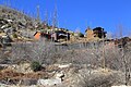
File:Remnants_of_the_2003_Aspen_Fire.jpg|Remnants of the 2003 Aspen Fire |
|||
File:MtLemmon Summerhaven Recovery From Aspen Fire.jpg|Picture of burnt pine trees, snow, and a cabin among the stark landscape after the Aspen Fire in 2003 |
|||
File:Mount_Lemmon_Ski_Valley.jpg|Mount Lemmon Ski Valley |
|||
File:Mountlemmonobservatory.JPG|thumb|View of the telescopes on Mount Lemmon |
|||
File:Cabins_atop_Mt_Lemmon_in_Summerhaven.jpg|Cabins atop Mt Lemmon in Summerhaven |
|||
File:(140) Mountlemmonobservatory.JPG|View of the telescopes on Mount Lemmon |
|||
File:Oracle AZ Mt Lemmon.JPG|View of Mount Lemmon from Oracle, AZ |
|||
File:Backside.jpg|Unpaved road on the north or "backside" of Mount Lemmon |
|||
File:SkyIslandPkwy.JPG|Catalina Highway climbing Mount Lemmon |
File:SkyIslandPkwy.JPG|Catalina Highway climbing Mount Lemmon |
||
File:Stereograph_-Mount_Lemmon_Highway.jpg|Stereograph of the Mt Lemmon Highway near Windy Point Vista. |
|||
File:Mtlemmon600.jpg|The Catalina Highway is a favorite of motorcyclists |
|||
File:Mt lemmon vista.JPG|A vista on the Catalina Highway at about 7,000 feet |
|||
</gallery> |
</gallery> |
||
==See also== |
==See also== |
||
* [[List of Ultras of the United States]] |
|||
* [[Mount Lemmon Observatory]] |
* [[Mount Lemmon Observatory]] |
||
* [[Mount Lemmon Ski Valley]] |
* [[Mount Lemmon Ski Valley]] |
||
| Line 299: | Line 259: | ||
==References== |
==References== |
||
{{ |
{{Reflist|30em}} |
||
==External links== |
==External links== |
||
{{Wikivoyage|Santa Catalina Mountains}} |
|||
{{commonscat-inline|Mount Lemmon}} |
|||
{{Commons category|Mount Lemmon}} |
|||
* Computer generated summit panoramas: |
|||
** [http://www.viewfinderpanoramas.org/panoramas.html index] |
|||
* {{cite gnis |id=30943 |name=Mount Lemmon}} |
|||
** [http://www.viewfinderpanoramas.org/panoramas/AME/Lemmon-N.gif North] |
|||
* {{cite summitpost |id=151231 |name=Mt. Lemmon}} |
|||
** [http://www.viewfinderpanoramas.org/panoramas/AME/Lemmon-S.gif South] |
|||
* [http://www.wrh.noaa.gov/total_forecast/index.php?wfo=twc&zone=azz033&fire=azz148&county=azc019&dgtl=1&lat=32.439583333333&lon=-110.78125 NOAA |
* [http://www.wrh.noaa.gov/total_forecast/index.php?wfo=twc&zone=azz033&fire=azz148&county=azc019&dgtl=1&lat=32.439583333333&lon=-110.78125 NOAA "Mount Lemmon Forecast"]. |
||
* {{cite web |url=http://tucson.com/news/blogs/streetsmarts/street-smarts-highway-mountain-named-for-botanist/article_c1c63977-e901-52c1-888d-ab2ef14dcdc6.html?id=201408 |author=David Leighton |title=Street Smarts: Highway, mountain named for botanist |work=Arizona Daily Star |date=January 5, 2015}} |
|||
* [http://raws.wrh.noaa.gov/cgi-bin/roman/meso_base.cgi?stn=AP020&time=MST Current Weather Conditions on Mt. Lemmon] |
|||
* [http://www.astronomycamp.org/lemmon.html Information about the astronomical observatory] |
|||
{{US prominent|state=collapsed}} |
|||
* [http://www.lpl.arizona.edu/css The Catalina Sky Survey] |
|||
{{Mountains of Arizona}} |
|||
{{Authority control}} |
|||
[[Category:Santa Catalina Mountains]] |
[[Category:Santa Catalina Mountains]] |
||
| Line 316: | Line 278: | ||
[[Category:Mountains of Arizona|Lemmon]] |
[[Category:Mountains of Arizona|Lemmon]] |
||
[[Category:Landforms of Pima County, Arizona]] |
[[Category:Landforms of Pima County, Arizona]] |
||
[[Category:Mountains of Pima County, Arizona]] |
|||
[[Category:North American 2000 m summits]] |
|||
[[fr:Mont Lemmon]] |
|||
[[he:הר למון]] |
|||
Latest revision as of 22:42, 24 March 2024
| Mount Lemmon | |
|---|---|
 View of Mount Lemmon from the western side of | |
| Highest point | |
| Elevation | 9,171 ft (2,795 m) NAVD 88[1] |
| Prominence | 5,157 ft (1,572 m)[2] |
| Listing | |
| Coordinates | 32°26′35″N 110°47′19″W / 32.442961983°N 110.788478444°W[1] |
| Geography | |
 Mount Lemmon | |
| Location | Tucson, Pima County, Arizona, U.S. |
| Parent range | Santa Catalina Mountains |
| Topo map | USGS Mount Lemmon |
| Climbing | |
| Easiest route | Catalina Highway |
Mount Lemmon, with a summit elevation of 9,159 feet (2,792 m),[1] is the highest point in the Santa Catalina Mountains. It is located in the Coronado National Forest north of Tucson, Arizona, United States. Mount Lemmon was named for botanist Sara Plummer Lemmon, who trekked to the top of the mountain with her husband and E. O. Stratton, a local rancher, by horse and foot in 1881.[4][5] Mount Lemmon is also known as Babad Do'ag, or Frog Mountain[6] to the Tohono O'odham.
Geography[edit]
Climate[edit]
Due to the elevation change from the bottom to the top, the summit of the mountain can be 20–30°F cooler than the base. It usually sees at least one snowfall during the winter months, making it a cool escape and popular tourist attraction for Tucson inhabitants.
Geology[edit]
Mount Lemmon is made up of Bolsa Quartzite, Dripping Spring Quartzite, and a local sandstone and conglomerate. The portions have been intruded by a Diabase Dike of the Apace Group.[7]
Summerhaven[edit]

Summerhaven is a small town near the top of the mountain. It is a summer residence for many, but there are some year-round residents. There are many small cabins, most of which were rebuilt after the Aspen Fire of July 2003.[8]
| Climate data for Mount Lemmon, Arizona (1958–2009) | |||||||||||||
|---|---|---|---|---|---|---|---|---|---|---|---|---|---|
| Month | Jan | Feb | Mar | Apr | May | Jun | Jul | Aug | Sep | Oct | Nov | Dec | Year |
| Record high °F (°C) | 65 (18) |
65 (18) |
68 (20) |
74 (23) |
82 (28) |
91 (33) |
89 (32) |
82 (28) |
81 (27) |
76 (24) |
71 (22) |
65 (18) |
91 (33) |
| Mean daily maximum °F (°C) | 49.2 (9.6) |
48.3 (9.1) |
52.9 (11.6) |
60.8 (16.0) |
69.1 (20.6) |
76.4 (24.7) |
76.5 (24.7) |
73.6 (23.1) |
70.4 (21.3) |
61.7 (16.5) |
56.3 (13.5) |
50.6 (10.3) |
62.2 (16.8) |
| Mean daily minimum °F (°C) | 22.8 (−5.1) |
21.8 (−5.7) |
25.7 (−3.5) |
31.7 (−0.2) |
36.6 (2.6) |
44.4 (6.9) |
49.8 (9.9) |
49.8 (9.9) |
45.1 (7.3) |
36.4 (2.4) |
29.7 (−1.3) |
24.3 (−4.3) |
34.8 (1.6) |
| Record low °F (°C) | −4 (−20) |
−7 (−22) |
−1 (−18) |
19 (−7) |
27 (−3) |
32 (0) |
39 (4) |
42 (6) |
31 (−1) |
20 (−7) |
4 (−16) |
4 (−16) |
−7 (−22) |
| Average precipitation inches (mm) | 3.15 (80) |
1.69 (43) |
1.17 (30) |
0.50 (13) |
0.42 (11) |
0.62 (16) |
4.41 (112) |
7.00 (178) |
3.39 (86) |
3.04 (77) |
2.95 (75) |
2.60 (66) |
30.94 (787) |
| Average snowfall inches (cm) | 16.5 (42) |
20.4 (52) |
6.8 (17) |
2.0 (5.1) |
0 (0) |
0 (0) |
0 (0) |
0 (0) |
0 (0) |
2.0 (5.1) |
6.2 (16) |
11.0 (28) |
64.9 (165) |
| Average precipitation days | 5 | 5 | 5 | 3 | 2 | 2 | 10 | 11 | 5 | 3 | 3 | 5 | 59 |
| Mean monthly sunshine hours | 241 | 243 | 299 | 325 | 374 | 372 | 327 | 319 | 315 | 301 | 260 | 242 | 3,618 |
| Source: Western Region Climate Center [9] | |||||||||||||
Mount Lemmon Station Observatory[edit]
At the peak is the Mount Lemmon Observatory, which was formerly the site of a USAF radar base of the Air Defense Command,[10] and the building that formerly housed a military emergency radar tracking station for landing the Space Shuttle at White Sands Missile Range. Although the United States military had a presence on the mountain for several decades all their facilities have been abandoned and were given to the United States Forest Service. The area and buildings that makes up the Mount Lemmon Station Observatory are leased from the Forest Service by the University of Arizona. The telescopes on the mountain are still used for astronomical research today by organizations such as the Catalina Sky Survey, the Mount Lemmon Sky Center,[11] the University of Arizona Astronomy Camp program,[12] the University of Arizona, and the University of Minnesota. The educational resources at the top of the mountain make it a unique research and teaching destination.
Catalina Highway[edit]
.jpg)
The Catalina Highway, also called the Mount Lemmon Highway, as well as the Hitchcock Highway (after Frank Harris Hitchcock), runs up the Santa Catalina Mountains from the east side of Tucson up to Summerhaven, at the top of Mt. Lemmon. The beautiful, curving road is a favorite drive for tourists, for locals escaping summer's heat and cyclists, and has been recently designated as the Sky Island Parkway, part of the US National Scenic Byway system.[13]
2010 saw the inaugural running of the Mount Lemmon Marathon.[14]
Fees and permits[edit]
Catalina Highway charges tolls for parking, camping, and hiking. However, the tolls are only officially charged for people who are camping. Tolls for other events, such as hiking, parking, or grilling, are a part of the honor system. Park rangers will not check for toll payments unless someone is using the park campgrounds. Anyone wishing to sightsee or travel to Summerhaven are not subjected to paying tolls.[citation needed]

Back side[edit]
An unpaved road to the summit on the north side of Mount Lemmon starts in Oracle, which is on Arizona Route 77 north of Tucson. It offers a secondary route to the top. This route is popular with off-road 4x4 drivers and with off-road or dual-purpose motorcyclists. This road ends at the Catalina Highway near Loma Linda. Before the Catalina Highway was built it was the only route up the mountain.[15]
-
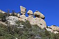 Hoodoos, Santa Catalina Mountains
 -
 Remnants of the 2003 Aspen Fire
 -
 Mount Lemmon Ski Valley
 -
 Cabins atop Mt Lemmon in Summerhaven
 -
 View of the telescopes on Mount Lemmon
 -
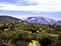 View of Mount Lemmon from Oracle, AZ
 -
 Unpaved road on the north or "backside" of Mount Lemmon
 -
 Catalina Highway climbing Mount Lemmon
 -
 Stereograph of the Mt Lemmon Highway near Windy Point Vista.


_Mountlemmonobservatory.JPG)


See also[edit]
- List of Ultras of the United States
- Mount Lemmon Observatory
- Mount Lemmon Ski Valley
- Mount Lemmon Survey
References[edit]
- ^ a b c "Catalina 2 Reset". NGS Data Sheet. National Geodetic Survey, National Oceanic and Atmospheric Administration, United States Department of Commerce. Retrieved August 18, 2016.
- ^ "Mount Lemmon, Arizona". Peakbagger.com. Retrieved February 7, 2014.
- ^ "Arizona County High Points". Peakbagger.com. Retrieved November 15, 2021.
- ^ "California Beat Hero: Sara Plummer Lemmon". CaliforniaBeat.org. May 27, 2009. Retrieved February 7, 2014.
- ^ Lemmon, J.G. (1881). "A botanical wedding trip" (PDF). Californian vol. 5. no. 24. pp. 517–525. Archived from the original (PDF) on April 2, 2015.
- ^ "How did Mt. Lemmon Get Its Name?". SouthernArizonaGuide.com. July 22, 2015. Retrieved August 6, 2021.
- ^ Bezy, John V. (2016). A Guide to the Geology of the Santa Catalina Mountains, Arizona: The Geology and Life Zones of a Madrean Sky Island (PDF) (Down to Earth #22 ed.). Tucson, AZ: The Arizona Geological Survey. ISBN 978-0-9854798-2-4. Retrieved September 2, 2020.
- ^ Faherty, John. "Town of Summerhaven back after devastating fire". AZ Central. Retrieved August 28, 2012.
- ^ "Mount Lemmon, Arizona Climate Summary". Western Regional Climate Center. Retrieved December 4, 2011.
- ^ "Air Defense Radar Stations". Radomes Inc. Retrieved August 28, 2012.
- ^ "SkyCenter". University of Arizona. Retrieved August 18, 2016.
- ^ "Astronomy Camp". University of Arizona SkyCenter. Retrieved August 18, 2016.
- ^ "Name change to Sky Island Parkway". Arizona Dept. of Transportation. Retrieved July 14, 2010.
- ^ Lacey, Marc (October 17, 2010). "A Finish Line With a Real High: 8,000 Feet". New York Times. Retrieved October 28, 2010.
- ^ "Backway to Mount Lemmon". Trails.com. Retrieved August 28, 2012.
External links[edit]
- "Mount Lemmon". Geographic Names Information System. United States Geological Survey, United States Department of the Interior.
- "Mt. Lemmon". SummitPost.org.
- NOAA "Mount Lemmon Forecast".
- David Leighton (January 5, 2015). "Street Smarts: Highway, mountain named for botanist". Arizona Daily Star.
| International | |
|---|---|
| National | |