15-ös főút
| 15-ös főút in Hungary | |||||||||||||||||||||||||||||||||||||||||||

|
|||||||||||||||||||||||||||||||||||||||||||
| map | |||||||||||||||||||||||||||||||||||||||||||
| Basic data | |||||||||||||||||||||||||||||||||||||||||||
| Operator: | Magyar Közút Nonprofit Zrt. | ||||||||||||||||||||||||||||||||||||||||||
| Start of the street: |
Mosonmagyaróvár |
||||||||||||||||||||||||||||||||||||||||||
| End of street: |
Rajka |
||||||||||||||||||||||||||||||||||||||||||
| Overall length: | 16 km | ||||||||||||||||||||||||||||||||||||||||||
|
Megyék ( counties ): |
|||||||||||||||||||||||||||||||||||||||||||
| The street in Mosonmagyaróvár | |||||||||||||||||||||||||||||||||||||||||||
|
Course of the road
|
|||||||||||||||||||||||||||||||||||||||||||
15-es főút (formerly 150-es főút ) ( Hungarian for 'main street 15') is a Hungarian main street . The now four-lane Autópálya M15 motorway was run essentially parallel to the road .
course
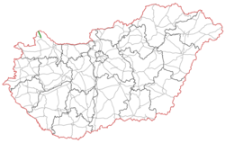
The road branches off in Mosonmagyaróvár (Wieselburg-Hungarian-Altenburg) from 1-es főút (main road 1) to the northwest, runs via Rajka (Ragendorf) to the Hungarian-Slovak border and forms part of Cesta I. triedy 2 in Slovakia which leads to Bratislava via Rusovce .
The total length of the road is 16 kilometers.
See also
Web links
Commons : 15-ös főút - collection of images, videos and audio files
- Hungarian Public Road Non-profit AG (Magyar Közút Nonprofit Zrt.) (Hungarian)
- National infrastructure developer, private company (Hungarian, partly English)
Individual evidence
- ↑ Magyarország, autóatlasz 1: 200,000, Honvédelmi Minisztérium Térképészeti Kht., ISBN 978-963-257-087-7 .

