
Argen and wetlands south of Langnau
The area Argen and wetlands south of Langnau was a protected area (SG number DE-8323342) in the south-east of the German state of Baden-Wuerttemberg, designated by the Tübingen regional council in accordance with Directive 92/43 / EEC (Fauna-Flora-Habitat Directive) . In 2015 it was merged with the FFH area Moore and Weiher around Neukirch in the FFH area Argen and wetlands near Neukirch and Langnau .
location
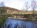
The approximately 508 hectare (ha) protected area Argen and wetlands south of Langnau belonged naturally to the Lake Constance basin and Westallgäu hill country . Its twelve partial areas were at an altitude of 394 to 564 m above sea level. NHN and extended to 82 percent (= 416.95 ha) in the Lake Constance district (communities Kressbronn am Bodensee , Langenargen , Neukirch and city of Tettnang ) and 18 percent (= 91.53 ha) in the district of Ravensburg (community Achberg and city Wangen ) .
In essence, the partial areas included the valley of the Argentine between the confluence of the upper - and lower Argentine at Neuravensburg and its mouth in the Lake between Kressbronn and Langenargen, the nature reserve Weiher , the Degersee , the Hammerweiher , the Hermann Weiher , the Langmoos Weiher , the Muttelsee , the Schachried nature reserve , Schleinsee and Wielandsee .
Bad

Degersee
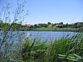
Muttelsee

Schleinsee

Wielandsee


Protection purpose
The main protection purpose was the preservation of the near-natural, alpine-influenced river landscape with the natural course of the Argen and the adjoining or nearby near-natural lakes and fens. As a testimony to a largely unadulterated wild river landscape, it is of supraregional importance.
Habitats
The diversity of habitat types , in large areas still largely natural, and the often unadulterated settlement structure with elements of traditional land use are interlinking elements between the foothills of the Alps and Lake Constance. The protected area is mainly characterized by the following habitats: mixed forest (22%), damp and mesophilic grassland (20%), inland water , deciduous and coniferous forest and non-forest areas with wooden plants (11% each).
Contiguous protected areas
The following eleven protected areas are part of the FFH area:
| No. | Surname | Places | Area share [%] |
image |
|---|---|---|---|---|
| LSG 4.36.051 |
Achberg Argentalnordhang with wide surroundings. |
Achberg | 3 |
 |
| NSG 4.282 |
Argen Near-natural river valley with alluvial and marsh forests, silting ponds , moors and swamps , reed beds , litter and wet meadows, gravel banks, spring areas, reed areas and wet meadows, numerous pristine, natural or near-natural impact, sliding and sliding slopes. |
Achberg , Kressbronn , Langenargen , Neukirch , Tettnang , Wangen | 53 |
 |
| LSG 4.35.002 |
Argenaue Reutenen Prehistoric river bed with relief andagricultural areas interruptedby groups of trees and littered meadows . |
Langenargen | 1 |
 |
| NSG 4.315 |
Berger Weiher limestone bog complex in the valley basin of a former pond with wet grass and pipe grass meadows and the butterflies that live there . |
Kressbronn - mountain | 1 |
 |
| NSG 4.206 |
Birkenweiher A partly as a stray field occupied small sedge Ried . |
Tettnang | 2 |
 |
| LSG 4.35.040 |
Ice Age Rims of the Argental with Argenaue A geological unit ofthe Argen glacial valley created during the last Ice Agefrom the delta in the south to the eastern border of the district. |
Kressbronn , Langenargen , Neukirch , Tettnang | 6th |
 |
| NSG 4.065 |
Hermannsberger Weiher A drained former pond , the bottom of which is now covered by a bog with a large number of remarkable plant communities. |
Achberg | 3 |
 |
| NSG 4.238 |
Hirrensee Richly structured ecosystem with a low-nutrient moor , meadow grass litter , wet and wet meadows as food and habitat for endangered meadow breeders, orchards and reed stands . |
Tettnang | 3 |
 |
| NSG 4.310 |
Schachried Large flat bog complex with various types of biotope: bog soils , litter and pipe grass meadows with a wealth offlora andfauna. |
Kressbronn , Tettnang | 2 |
 |
| LSG 4.35.034 |
Lake plateau and hill country south of the Argen and Nonnenbachtal hilltop landscape with embedded lakes, stream valleys and wooded hills in their scenic diversity and natural biotopes still present in large numbers (wetlands and semi-arid grasslands). |
Kressbronn , Tettnang | 23 |
 |
| LSG 4.35.001 |
Württemberg shore of Lake Constance Natural beaches and beach forests of Lake Constance with black poplar and oak trees as the predominant wood on the shore. |
Friedrichshafen , Kressbronn , Langenargen | 1 |
 |
Flora and fauna
flora
Plants listed in Annex II of Directive 92/43 / EEC :
- Fen orchid ( Liparis loeselii ), a strictly protected species from the represented with about 300 species worldwide genus gloss herb (Lipari) in the family of orchids (Orchidaceae).
fauna
Animal species listed in Annex II of Directive 92/43 / EEC:
-
Invertebrates
- Green damsel ( Ophiogomphus cecilia ), a species of dragonfly from the family of the river damsel ( Gomphidae ), which belongs to the large dragonflies ( Anisoptera )
- Helmet azure damsel ( Coenagrion mercuriale ), a species of dragonfly from the family of the slender dragonfly (Coenagrionidae)
- Narrow diaper snail ( Vertigo angustior ), a species of the diaper snail family (Vertiginidae)
- Scabiosen-Scheckenfalter ( Euphydryas aurinia ), a butterfly (day butterfly ) from the family of the noble butterfly (Nymphalidae)
- Stone or brook crayfish ( Austropotamobius torrentium ), the smallest originally European cancer
- Four-toothed diaper snail ( Vertigo geyeri ), also a type of snail from the family of diaper snails
-
fishes
- Bullhead ( Cottus gobio ), a small freshwater fish from the Bullhead family (Cottidae)
- Strömer ( Leuciscus souffia ), a species of fish belonging to the carp fish
See also
Web links
- Profile of the protected area at the State Institute for the Environment, Measurements and Nature Conservation Baden-Württemberg (LUBW)
- Climate data and scenarios for the protected area from the Potsdam Institute for Climate Impact Research (PIK)
Individual evidence
Coordinates: 47 ° 37 ′ 58 ″ N , 9 ° 39 ′ 14 ″ E
Argen and wetlands near Neukirch and Langnau | Lake Constance hinterland near Überlingen | Lake Constance hinterland between Salem and Markdorf | Shore of Lake Constance west of Friedrichshafen | Lake Constance landscape east of Friedrichshafen | Deggenhauser Valley | Rotachtal Bodensee | Schussenbecken with ravine forests south of Blitzenreute | Überlinger See and Lake Constance landscape | Lower Argen and side valleys
Former FFH areas: Argen and wetlands south of Langnau | Moors and ponds around Neukirch | Schussenbecken and Schmalegger Tobel
Adelegg | Aitrach, Ach and Dürrenbach | Altdorf Forest | Argen and wetlands near Neukirch and Langnau | Bodenmöser and Hengelesweiher | Wetlands near Waldburg and Kißlegg | Wetlands around Altshausen | Wetlands around Bad Schussenried | Wetland complexes north of Isny | Upper Argen and side valleys | Pfrunger Ried and lakes near Illmensee | Red, Bellamonter Rottum and Dürnach | Rotachtal Bodensee | Schussenbecken with ravine forests south of Blitzenreute | Umlachtal and Riss south of Biberach | Lower Argen and side valleys | Wurzacher Ried and Rohrsee
Former FFH areas: Ach and Dürrenbach | Aitrach and Hergottsried | Argen and wetlands south of Langnau | Beech forests near Fronhofen | Wetlands near Waldburg | Moors and ponds around Neukirch | Schussenbecken and Schmalegger Tobel | Tobel forests near Blitzenreute | Ponds and moors around Kisslegg