
Chazeuil (Nièvre)
| Chazeuil | ||
|---|---|---|
|
||
| region | Bourgogne-Franche-Comté | |
| Department | Nièvre | |
| Arrondissement | Clamecy | |
| Canton | Corbigny | |
| Community association | Tannay-Brinon-Corbigny | |
| Coordinates | 47 ° 17 ' N , 3 ° 24' E | |
| height | 227-382 m | |
| surface | 4.61 km 2 | |
| Residents | 59 (January 1, 2017) | |
| Population density | 13 inhabitants / km 2 | |
| Post Code | 58700 | |
| INSEE code | 58070 | |

Chazeuil is a French municipality with 59 inhabitants (at January 1, 2017) in the department of Nièvre in the region of Bourgogne Franche-Comté (before 2016 Bourgogne ). It belongs to the Arrondissement of Clamecy and the canton of Corbigny ( Brinon-sur-Beuvron until 2015 ). The inhabitants are called Chazuilois .
geography
Chazeuil is about sixty kilometers south-southwest of Auxerre on the edge of the Morvan . Chazeuil is surrounded by the neighboring communities of Corvol-d'Embernard in the north, Chevannes-Changy in the east, Authiou in the south and east, Arzembouy in the south-west and Champlemy in the north-west.
Population development
| year | 1962 | 1968 | 1975 | 1982 | 1990 | 1999 | 2006 | 2011 | 2016 |
| Residents | 73 | 66 | 73 | 54 | 39 | 51 | 68 | 54 | 61 |
| Source: Cassini and INSEE | |||||||||
Attractions
- Saint-Denis church from the 15th century
- Domains Upper and Lower Castle from the 19th century
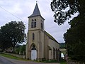
Saint-Denis church

Upper lock

Lower lock


literature
- Le Patrimoine des Communes de la Nièvre. Volume 1, Flohic Editions, Charenton-le-Pont 1999, ISBN 2-84234-054-X , pp. 59-60.
Web links
Commons : Chazeuil - collection of images, videos and audio files