Cyr Plantation
| Cyr Plantation | ||
|---|---|---|
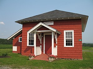
 Former school, now serves as the town hall for Plantation Cyr |
||
| Location in Maine | ||
|
|
||
| Basic data | ||
| Foundation : | March 12, 1870 | |
| State : | United States | |
| State : | Maine | |
| County : | Aroostook County | |
| Coordinates : | 47 ° 5 ′ N , 68 ° 0 ′ W | |
| Time zone : | Eastern ( UTC − 5 / −4 ) | |
| Residents : | 103 (as of 2010) | |
| Population density : | 1 inhabitant per km 2 | |
| Area : | 99.3 km 2 (approx. 38 mi 2 ) of which 99.3 km 2 (approx. 38 mi 2 ) is land |
|
| FIPS : | 23-15990 | |
| GNIS ID : | 00582430 | |
| Website : | cyrplantation.com | |
Cyr Plantation is a plantation in Aroostook County in the state of Maine in the United States . In 2010, 103 people lived there in 48 households on an area of 99.3 km².
geography
According to the United States Census Bureau , Cyr Plantation has a total area of 99.3 km², which consists entirely of land.
Geographical location
Cyr is located in the north of Aroostook County. Close to the Canadian border and the Saint John River . Several smaller rivers run through the area of the plantation, on which there are also several small lakes. The surface of the area is slightly hilly, the highest point is the 308 m high Moose Hill .
Neighboring communities
All distances are given as straight lines between the official coordinates of the places from the 2010 census.
- North: Van Buren , 11 miles
- East: Hamlin , 2.2 miles
- South: Unorganized Territory Connor , 9 mi
- West: Stockholm , 13.1 km
climate
The mean mean temperature in Cyr Plantation is between -11.7 ° C (11 ° Fahrenheit ) in January and 18.3 ° C (65 ° Fahrenheit) in July. This means that the place is around 10 degrees cooler than the long-term average in the USA. At over five and a half meters, the snowfalls between October and May are almost twice as high as the average snow depth in the USA, the daily sunshine duration is at the lower end of the range in the USA.
history
Cyr was settled in 1824, officially recognized and the plantation was named in Cyr on March 12, 1870, previously it was known as Township L R2 . It was previously organized in 1857 so that the population could get the right to vote. In the 1880s the village had more than 500 inhabitants and there were 4 public schools.
The Governor Brann School was listed on the National Register of Historic Places in 1993. This historic building hosts the Cyr Plantation community meetings during the warmer months. To save heating costs, these are held in Van Buren in winter.
Today Cyr is closely connected to the town of Van Buren and is partly viewed as a suburb of Van Buren.
Population development
| Census Results - Plantation of Cyr, Maine | ||||||||||
|---|---|---|---|---|---|---|---|---|---|---|
| year | 1800 | 1810 | 1820 | 1830 | 1840 | 1850 | 1860 | 1870 | 1880 | 1890 |
| Residents | 376 | 558 | 429 | |||||||
| year | 1900 | 1910 | 1920 | 1930 | 1940 | 1950 | 1960 | 1970 | 1980 | 1990 |
| Residents | 502 | 531 | 479 | 521 | 433 | 256 | 233 | 155 | 147 | 142 |
| year | 2000 | 2010 | 2020 | 2030 | 2040 | 2050 | 2060 | 2070 | 2080 | 2090 |
| Residents | 117 | 103 | ||||||||
Economy and Infrastructure
traffic
The plantation is located on US Highway 1 which connects the plantation to the north with Van Buren and to the south with Caribou.
Public facilities
Cyr Plantation does not have its own library. The closest is the Abel J. Morneault Memorial Library in Van Buren.
There is no hospital or medical facility in Cyr Plantation. The closest hospital to Cyr Plantation and the region is in Van Buren.
education
Cyr Plantation belongs with Van Buren and Hamlin to the Maine School Administrative District No. 24 .
There are several schools in the school district for school children:
- Van Buren District Elementary School in Van Buren
- Van Buren District Secondary School in Van Buren
literature
- Edward Wiggin: History of Aroostook . tape 1 . The Star-Herald Press, Presque Isle ME 1922, p. 186 ff . ( Digitized version ).
Web links
- Homepage of the municipality (English)
- Data from the 2010 census
- Cyr Plantation on maine.gov
Individual evidence
- ↑ Cyr Plantation in the United States Geological Survey's Geographic Names Information System , accessed January 7, 2018
- ↑ Maine 2010 Census Results ; official publication of the Census Authority, (English; PDF; 32.5 MB)
- ^ Moose Hill . In: peakery.com . ( peakery.com ).
- ↑ Coordinates of the locations of the Census Authority 2010
- ↑ Hamlin, Maine (ME 04785) profile: population, maps, real estate, averages, homes, statistics, relocation, travel, jobs, hospitals, schools, crime, moving, houses, news, sex offenders. In: city-data.com. www.city-data.com, accessed on January 7, 2018 (English).
- ↑ Cyr Plantation. Maine to Encyclopedia, accessed April 7, 2015 .
- ↑ Asset Detail. In: nps.gov. npgallery.nps.gov, accessed January 7, 2018 .
- ↑ Cyr Plantation - Info. In: cyrplantation.com. Retrieved January 7, 2018 (American English).
- ↑ Population 1870-2010 according to census results
- ↑ Msad # 24 / rsu # 88. In: msad24.org. Retrieved January 7, 2018 .

