
Eygelshoven
 flag |
 coat of arms |
| province |
|
| local community |
|
|
Area - land - water |
1.24 km 2 1.23 km 2 0.01 km 2 |
| Residents | 2,175 (Jan 1, 2018) |
| Coordinates | 50 ° 54 ' N , 6 ° 4' E |
| height | 99 m NAP |
| Important traffic route |
|
| prefix | 045 |
| Postcodes | 6373-6374, 6461, 6464, 6468-6469, 6471 |
 |
|
Eygelshoven ( Limburgish Egelze ) is a village in the southeast of the Netherlands . Eygelshoven is located in the province of Limburg and is now the northernmost district of the border town of Kerkrade .
Until the municipal area reform ( gemeentelijk herindeling ) in 1982, Eygelshoven formed an independent municipality . In 2018 the population of Eygelshoven was around 2,175 in the center. Including the surrounding hamlets and settlements of Hopel , De Kom , Op de Bossen and Waubacherveld, Eygelshoven and the Kerkrade-Noord district have 13,060 inhabitants.
geography
Geology / morphology
In the south there are foliage layers of carbon , while those in the north of the Feldbiss fault merge into sedimentary layers of the Holocene. The north part steeply dipping layers of carbon lead several coal seams , which regularly continued from neighboring Wurmrevier form known seams.
Eygelshoven is located in the middle of a cross-border urban agglomeration , the so-called Parkstad Limburg , which includes the large municipalities and cities of Heerlen , Kerkrade , Landgraaf , Brunssum , Voerendaal , Schinnen and Onderbanken . Eygelshoven has, however, been able to retain a good part of its village character. Together with the Egelzer plat , the local dialect, which differs significantly from the dialect of the city of Kerkrade, this is an indication of the former independence of the place. On the borders well into the Rhineland in Eygelshoven has been known since the 1950s for its weekly market every Saturday, thousands of visitors from the Netherlands, Germany and Belgium attracts.
Eygelshoven is located in the Wurmtal at the mouth of the Amstelbach and Dentgenbach in the Wurm . In the northwest along the Wurm the place borders on Germany, in the north and east on Landgraaf. In the meantime, the place has grown together with the neighboring settlements of the city of Kerkrade, on the one hand in an easterly direction along the Veldhofstraat / Meusersraat with the district Hanrade and on the other hand in a south direction west of the Kerkradersteenweg / Eygelshovergracht with the district Chevremont. Eygelshoven was originally separated from these by forests. Some of these fell victim to mining and some to new housing estates. However, this is compensated for elsewhere by creating a park landscape on disused agricultural and industrial areas. In addition, the valley of the Amstelbach (nl. Anselderbeek ) - this is known as the Groene Long (Green Lung) - and the Dentgenbach southwest of the village are a worth seeing local recreation area . This also applies to the Wurmtal.
Expansion of the urban area
The historic municipality of Eijgelshoven largely corresponded to the present-day district of Kerkrade-Noord. In the north, Eygelshoven borders the municipality of Landgraaf, district of Rimburg. In the northeast, the Wurm separates the place from the German Herzogenrath / district Hofstadt and Worm / Wildnis. To the west is the Kerkrad district of Haanrade or aan de Baan. In the south, Eygelshoven borders on the district of Chevremont , the "green lung" (ndl. Groene long) and in the southwest and west on the municipality of Landgraaf (Dentgenbach industrial area or district of Schaesberg).
Eygelshoven or Kerkrade-Noord today consists of the town center around the market and the two churches. To the south of it, west of the Amstelbach (Anselderbeek), is the “de Kom” settlement, including the former “Kommerveld” colliery colony. Separated from this, by the main line between Kerkrade-Nord and Kerkrade-West (Laurastraat), is the Lauradorp development area, followed by the listed and restored colliery colony de Hopel. There is the Eygelshoven (also: Hopel) station of the Dutch railway company Nederlandse Spoorwegen . On a wooded hilltop east of the Amstelbach and south-east of the town center, the district "Op de Bossen" (above the forest) developed as a miners' colony, which today has grown together with the district "Vink", which is therefore historically incorrect geographically sensible and administratively fixed, today belongs to Eygelshoven.
history
The village was first mentioned in 1131 under the name Eigelsowen in the Annales Rodenses , the chronicle of the nearby Benedictine abbey of Rolduc . A Roman settlement of the local area is to be assumed. During construction work in the local area, more precisely in the area of the "Holtskuil" corridor , the remains of a Roman country house, as there were numerous others in this region, were discovered. Earlier finds also point to a settlement in the first century AD.
Originally the place was a farming village and agriculturally oriented. Modest craft and trade completed the picture. However, this was to change fundamentally as a result of prospecting work by German engineers at the beginning of the 20th century.
Before the Napoleonic expansion , Eygelshoven was part of the Duchy of Jülich ; Strictly speaking, Eygelshoven belonged to Heyden, the so-called Haydener Ländchen, whose northern exclave was Eygelshoven. After the annexation by Napoleon, Eygelshoven came to the Meuse-Inférieure department . In 1815, after the Wars of Liberation and the restitution of Europe at the Congress of Vienna , the place fell to the Netherlands.
However, it was again two Germans who were to acquire very special significance for the Eygelshoven. In 1870 the mill owner Anton Wackers , who came from neighboring Herzogenrath, and his brother-in-law Gustav Schümmer carried out test drillings for coal in the area of what was then the municipality of Eygelshoven, where coal had been found a few years earlier. The Laura concession was soon awarded based on the exploration results. This was soon merged with the older Vereeniging concession . In 1901 and 1902 the two shafts of the "Laura" mine that was being built were sunk. To the chagrin of the concession holders, it soon became apparent that the concession area had been divided into two halves by a geological fault, the so-called Feldbiss , which was also noticeable in the neighboring worm area . At the time, tunneling through the fracture zone was out of the question. The Feldbiss-breuk continues across Limburg and is part of a still active fracture zone on the northern edge of the Rhenish slate mountains . Therefore, another mine had to be built in the northern part of the coal field for mining. This happened with the construction of the Julia mine immediately north of the village, directly on the Herzogenrath-Heerlen railway line . After the start of production was delayed until 1926, this mine was considered to be one of the youngest and most modern mines in Europe until its closure at the end of 1974, despite the sometimes unfavorable storage conditions underground . In addition to coal washing and loading, workshops, etc., a power station was also connected, which only went offline a few years after the colliery was closed.
Mining changed Eygelshoven through immigration from other parts of the Netherlands, from Germany and partly also from Eastern Europe ( Silesia and Bohemia ), who were needed as workers on the two mines. A population explosion and brisk construction activity were the consequences. From the turn of the century to around 1925, the population had increased tenfold. After attempts were initially made to settle the miners and their families in colonies outside of the village (for example "de Hopel"), they nonetheless quickly grew together with the town center and roughly gave the townscape today. The mine closings as a result of the Nota den Uyll marked a deep cut in the history, structure and society of Eygelshovens. Although attempts were made to create replacement jobs as part of the so-called herstruktureering , Eygelshoven initially went down economically after the Laura & Vereeniging (1968) and Iulia (1974) collieries were closed. This is documented by a number of houses along the Veldhovstraat that are often threatened by decay, some of them uninhabited, with shops on the ground floor. Above all, the gastronomy, but also large parts of the retail trade and the craft sector fell sharply. The Iulia was the last hard coal mine to produce coal in the Netherlands when production was stopped on December 31, 1974. The terrain of the Julia mine in the north of Eygelshoven has since been rededicated as an industrial and commercial park, while the terrain of the sister mine Laura has been gradually developed into the Lauradorp housing estate with residential buildings and a small central park .
One of the hallmarks of Eygelsoven's history is the fact that, soon after the coal deposits were discovered, most of the time the economic well-being of the place was in “foreign” hands. For a long time, the shareholders came from Brussels . It was SA Générale, an industrial conglomerate from which other corporations , such as Fortis Bank, emerged. From May 1940 to September 1944, Eygelshoven was under National Socialist rule until American troops liberated the village as part of Operation Market Garden .
Today it is largely unknown that lignite was also mined in the local area , but this rather insignificant episode ended in the middle of the 20th century.
On December 31, 1981 Eygelshoven was incorporated into Kerkrade. Only smaller districts (Waubacherveld) came to the newly created municipality Landgraaf . Since then, larger cities have been divided into urban districts, so-called Wijken , based on physiognomic and spatial planning aspects . In this way, Eygelshoven forms the Wijk Kerkrade-Noord with the immediately adjacent settlements. Since 2005 there have been official blue place-name boards at the city entrances to the north and east, which do not have the municipality name Kerkrade , but the name Eygelshoven, once in the Dutch spelling as "Eijgelshoven" and once in the Limburg version as "Egelse ". Eijgelshoven (with IJ) was the usual spelling before 1982.
Religions
The most important religion in Eygelshoven is Roman Catholic Christianity , due on the one hand to its location in the traditionally Catholic southern Limburg ( Diocese of Roermond ), and on the other hand to the predominantly Catholic immigration from Eastern Europe in the early 20th century. There are also numerous Protestants and Muslims. The former are mainly due to Dutch internal migration from the north as a result of the expansion of state institutions in the country's former growth region, while the Muslims are due to immigrants from Indonesia and guest workers from Turkey and Morocco . Other faiths hardly play a role.

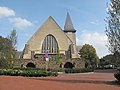
Eygelshoven, church: het Kleine Kerkje
Eygelshoven, church


politics
Municipal council
For Eygelshoven and Kerkrade-Noord, a district manager (from the left Wijkmanager) acts as the local authority contact . Currently this is Mr. Wil Franssen. Incidentally, since the merger in 1982, local affairs have been directed from Kerkrade .
mayor
Former mayors of the formerly independent municipality of Eygelshoven were:
- 1919–1928 Willem M. Loyson
- 1928–1934 JH Martin
- 1934–1969 HJ Boijens
- 1969–1975 JGA Janssen
- 1975-1982 JH Ch. Persoon; (he was the last mayor of Eygelshoven)
coat of arms
The Eygelshoven coat of arms is split. Right: A black lion with a red tongue standing in gold. This symbolizes the former affiliation of the place to the Duchy of Jülich ("Jülich lion"). Left: the left upper corner blue and the left flank point gold, across both points a silver and red crossbar. The base of the coat of arms is formed by a silver triangle with black sticks and iron as symbols for the former coal mining.
Town twinning
The former independent municipality Eygelshoven maintained a town partnership with the then equally independent municipality Rodenkirchen (now Rodenkirchen (Cologne) ). As both communities as part of a municipal reorganization to Kerkrade or to Cologne were divided, the cities of Kerkrade and Cologne have translated the partnership relations. Two streets in Cologne were named after Eygelshoven and Kerkrade.
Buildings and sights
Among the sights in Eygelshoven, the two Roman Catholic houses of God and the listed ensemble on the Kerkberg (Kirchberg) are the first to be mentioned. The current parish church of H. Johannes de Dooper (St. John the Baptist ) was inaugurated in 1922 as a new building approx. 200 m northeast of the market square. It replaced the old, dilapidated and, due to the massive population growth, too small "oude kerkje" (old church), the oldest part of which, the Romanesque choir, can be dated back to 1513. Presumably, however, in the same strategically favorable location (acropolis location) on the Kerkberg there was a probably wooden church or chapel , because the parish of Saint John the Baptist in Eygelshoven was mentioned in a document as early as 1371. "Het Oude Kerkje" (dt. Old church), as the listed old church is popularly known, changed hands several times and has been renovated several times. Today a mass is celebrated there every Saturday in Latin . The church is also very popular with married people. Opposite the "Oude Kerkje" there are a number of small, listed half-timbered houses that date from the 18th century, as well as a not far from it, also a listed square courtyard from 1794. Several other formerly important courtyards are or were the Laethof (renovated , Monument), the Veldhof and the Berghof (the latter are only preserved as street names). Another old square courtyard is located directly on the Amstelbach (which runs underground in parts) on the "Groote Stegel". Another attraction is the restored Hopel miners' colony. She provided the backdrop in the famous Dutch saga Antonia (with Willeke van Ammelrooy in the lead role). This Dutch-Belgian cinema production by director Marleen Gorris was awarded an Oscar in Hollywood in 1996 in the category “best foreign film”. here
Museums
Eygelshoven does not have a museum. However, in the Industrion , an industrial museum located in Kerkrade, there is information about and exhibits from the former mines in the local area.
music
Every Saturday there is a men's choir called Schola St. Johannes for mass in the old church. The Café de Kachel serves as a platform for regional musicians and DJs. In addition, unknown artists exhibit their works there on a monthly basis. The majority of the artists come from the German-Dutch-Belgian border region.
Sports
There are a number of sports clubs in Eygelshoven:
- The LHC (Laura Hopel Combinatie) is a football club. It emerged from the former clubs RKEEV Laura Eygelshoven and VV Hopel Kerkrade, which had shared the common sports field on Anselderlaan since 1975.
- The TCLE (Tennis Club Laura Eygelshoven) is a tennis club whose facilities are also located on the Anselderlaan.
- The BC Cosmos 77 is a badminton club . Its sports facilities are located in the Socio-Project, a community building in the center of the village, which houses a gym, a library, an ice cream parlor and other facilities.
- Scouting Eygelshoven is a member of the worldwide scout community and resides in the restored Laethof, a former homestead that is over 200 years old.
- Country Dancers The Dutchy's (dance group)
- Schietvereniging St. Hubertus (Schützenverein)
- Schuttersbroederschap St. Sebastianus (Shooting Club)
Regular events
- Carnival / Fastnacht is celebrated every year with numerous events and hardly differs from the cultivation of customs in the neighboring carnival strongholds of the Rhineland.
Economy and Infrastructure
Originally a small agricultural village, an economic structure focused on the two mines developed, as is typical for a mining settlement .
In the first half of the 20th century, the region around Kerkrade , Heerlen , Hoensbroek , Brunssum , Eygelshoven and Schaesberg became the center of Dutch coal mining. The region was also called "Oostelijke Mijnstreek" (there was also a "Westelijke Mijnstreek", which was formed by the municipalities of Beek, Schinnen, Stein and the then independent municipality of Geleen).
Since the end of mining in December 1974, the place went through a significant economic decline. In addition to the mines and the related businesses (power plant, workshops, suppliers, etc.), the number of catering establishments fell sharply, as did retail and parts of the craft. For several years now, smaller and medium-sized businesses have been settling in the Iulia industrial park on the site of the former colliery of the same name. Previously, individual follow-up operations to the mine, mainly in the area of dump recycling , and a metal construction company ( Laura Metaal ) were the only notable operations at the site.
traffic
Route connections
| Train type | Line course | frequency |
|---|---|---|
| Arriva Sneltrein RE 18 ( LIMAX ) | Maastricht - Meerssen - Valkenburg - Heerlen - Landgraaf - Eygelshoven market - Herzogenrath - Aachen West - Aachen main station | hourly |
| Arriva Stoptrein RS15 | Kerkrade Centrum - Chevremont - Eygelshoven - Landgraaf - Heerlen De Kissel - Heerlen - Hoensbroek - Nuth - Schinnen - Spaubeek - Geleen Oost - Sittard | every half hour |

Eygelshoven has a station on the Kerkrade-Heerlen railway line, on the so-called million line (Miljoenenlijn), which is served every half hour. Since December 2007, the Kerkrade-Heerlen-Maastricht ( Heuvellandlijn ) route is no longer served by the Nederlandse Spoorwegen , but by Arriva Nederland. The stopping point is at the Hopel settlement. There is one of three feeders to the N299 expressway between the German-Dutch border near Kerkrade and the northern part of Parkstad Limburg (Landgraaf, Brunssum, Hoensbroek). Five arterial roads connect the town with the surrounding area. Four of them meet in the center of the village. At the end of 2007, a second train station "Eygelshoven-Markt" opened, which was operated by Deutsche Bahn on the Heerlen – Herzogenrath route and on to Aachen until December 2015, the regional train line RB 20 Euregiobahn and then hourly trains on the RE line in both directions 18 is served. This station is centrally located, only about a minute's walk from the market and town center (behind the Kerkberg).
media
The Anselbode is a local (Catholic) parish newspaper and appears weekly.
Public facilities
- Sport en Cultuur Stichting Eygelshoven (short: Socioproject) including a public library as well as sports, cultural and community facilities.
- Scouting Eygelshoven
- Weekly market (every Saturday)
military
On December 15, 2016, the Eygelshoven Army Depot-BENELUX of the United States Army Materiel Command was opened in Eygelshoven as part of the US European Reassurance Initiative (ERI) and the Army Prepositioned Stock Program , in which around 300 US and Dutch soldiers and civilian employees are employed and are storing supplies for an armored division.
education
- Basic school "de Veldhof"
Personalities
- Hein Simons alias Heintje , musician and singer, celebrated child star 1968–1974, spent most of his childhood and youth in Eygelshoven, where he and his parents lived in a house on Wimmerstraat until shortly before his breakthrough with the hit "Mama".
- Pierre Kemp (1886–1967), one of the most important Dutch poets of the 20th century, was employed for many years in the wages office of the mining company Laura & Vereeniging . He wrote many of his shorter poems while taking the train to work or home to Maastricht after work .
- Wim Schmitz (* 1964), German-speaking author.
sons and daughters of the town
- Peter Joseph Valckenberg (1764-1837); Mayor of Worms from 1813 to 1837 .
- Laurens Bisscheroux , architect and artist (1934–1997)
- Wilma Ohly , German local politician (* 1936)
- Frans Willeme (* 1952), Dutch and Lower Saxony local politician
- JJ (Jan) Latten (* 1952), sociologist and demographer at the Centrale Bureau voor Statistiek ; Professor at the University of Amsterdam .
- Ben Herbergs (* 1947), publicist, author and editor
- Roger Braun (* 1972), painter / sculptor
- Stefan Heijdendael (* 1974), VPRO radio program editor and photographer
Web links
- Website for the urban district ( wijk ) Kerkrade-Nord , including the old municipality Eygelshoven with the districts ( burten ) Eygelshoven, Hopel, De Kom, Kommerveld, Berghof, Op de Bossen and Waubacherveld as well as the industrial area ( industrieterrein ) Iulia.
- Eygelshoven near Kerkrade, Gisteren en Vandaag
Individual evidence
- ↑ a b c Kerncijfers wijken en buurten 2018 Centraal Bureau voor de Statistiek , accessed on July 31, 2018 (Dutch)
- ↑ aachener-zeitung.de December 12, 2012: Always new damage: The mining industry is catching up with Parkstad
- ↑ http://www.luftpost-kl.de/luftpost-archiv/LP_16/LP00217_030117.pdf