
Big small
|
market community Big small
|
||
|---|---|---|
| coat of arms | Austria map | |
 |
|
|
| Basic data | ||
| Country: | Austria | |
| State : | Styria | |
| Political District : | Leibnitz | |
| License plate : | LB | |
| Surface: | 27.72 km² | |
| Coordinates : | 46 ° 44 ' N , 15 ° 27' E | |
| Height : | 319 m above sea level A. | |
| Residents : | 2,256 (January 1, 2020) | |
| Postcodes : | 8452, 8441, 8443, 8451, 8453, 8462 | |
| Area code : | 03456 | |
| Community code : | 6 10 13 | |
| NUTS region | AT225 | |
| Address of the municipal administration: |
Big Small 120 8452 Big Small |
|
| Website: | ||
| politics | ||
| Mayor : | Johann Hammer ( ÖVP ) | |
|
Municipal Council : (2015) (15 members) |
||
| Location of Großklein in the Leibnitz district | ||
  |
||
 View of Großklein from the Burgstall |
||
| Source: Municipal data from Statistics Austria | ||


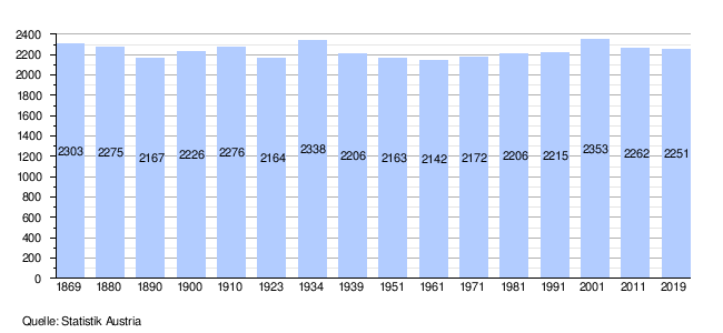
Großklein is a market town in the Leibnitz district , Styria , Austria with 2,256 inhabitants (as of January 1, 2020).
geography
For tourism , it is described as an idyllic community. It is located on the South Styrian Wine Route and thus at the entrance to the so-called Styrian Tuscany . The highest point in the municipality is 633 m above sea level. A. high Kreuzberg .
Community structure
On September 1, 1968, the small community was renamed Großklein.
The community consists of the cadastral communities (area 2001):
- Burgstall 122.94 ha,
- Gold 447.33 ha,
- Big Small 425.69 ha
- Mantrach 268.62 hectares,
- Mattelsberg 192.61 ha,
- Nestelbach 195.89 ha,
- Nestelberg near Großklein 499.34 ha and
- Oberfahrenbach 619.57 ha.
Localities (population in brackets as of January 1, 2020) in the municipality are:
- Burgstall (140)
- Gold (182)
- Big & Small (654)
- Mantra (365)
- Mattelsberg (214)
- Nestelbach (167)
- Nestelberg (338)
- Oberfahrenbach (196)
Other districts are Kleinklein and Wippelsach.
Neighboring communities
Neighboring communities are: Leutschach an der Weinstrasse , Gamlitz , Gleinstätten , Heimschuh , Kitzeck im Sausal and Sankt Johann im Saggautal .
history
Place name
Until 1968 the community was called Klein , Großklein was one of the localities. To avoid confusion, the name Großklein has since been used for the entire community. In the 15th century, Großklein was known as Michel Klawn , while Kleinklein was known as Little Klawn . The place name Klein goes back to Slovenian roots and can be traced back to glina (clay) or kljun (beak, shaped like a hallway).
Population development
politics
mayor
Mayor of Großklein is the postal worker Johann Hammer (ÖVP).
The community board also includes the deputy mayor Josef Kolar (ÖVP) and the community treasurer Franz Knieli (ÖVP).
Head of office is Renate Tscheppe.
Municipal council
The municipal council consists of 15 members. According to the result of the 2015 municipal council elections , this is composed as follows:
| Political party | 2015 | 2010 | 2005 | 2000 | ||||||||
|---|---|---|---|---|---|---|---|---|---|---|---|---|
| Sti. | % | M. | Sti. | % | M. | Sti. | % | M. | Sti. | % | M. | |
| ÖVP | 844 | 56 | 9 | 836 | 59 | 9 | 895 | 63 | 10 | 1067 | 73 | 12 |
| SPÖ | 266 | 18th | 2 | 482 | 34 | 5 | 445 | 31 | 5 | 222 | 15th | 2 |
| FPÖ | 125 | 8th | 1 | 88 | 6th | 1 | 83 | 6th | 0 | 104 | 7th | 1 |
| Independent list large small | 279 | 18th | 3 | not running | not running | not running | ||||||
| The green | not running | not running | not running | 63 | 4th | 0 | ||||||
| Eligible voters | 1.919 | 1,889 | 1,881 | 1,778 | ||||||||
| voter turnout | 80% | 75% | 77% | 83% | ||||||||
coat of arms
The municipal coat of arms was awarded in 1969.
Description: "Black hill covered with a silver antique cinder
urn on the silver shield, two red roses floating above it" Legend: The urn stands for the Hallstatt-era Gau principality on the Burgstallkogel (an ancestor of the state capital). The roses for the Trautmannsdorfer, they owned Ottersbach Castle in Mantrach for a while. Meaning of the coat of arms: love overcomes death.
Tourism association
Together with Gleinstätten, Heimschuh, Kitzeck im Sausal, St. Andrä-Höch, St. Johann im Saggautal, St. Nikolai im Sausal and Tillmisch, the municipality forms the "Sulmtal Sausal - Südsteirisches Weinland" tourism association. Its seat is Kitzeck in Sausal.
Culture and sights
- Parish church hl. George and cemetery

Significant grave finds from the Hallstatt period were discovered in Kleinklein . During walks in the forests around Goldes one often comes across small to medium-sized hilltops, which under their layer of soil overgrown Hallstatt-era graves ( tumulus ) accommodate. The Hallstatt Museum presents finds and findings from the region from around five and a half millennia. They span a period from the Neolithic to the late Middle Ages.
The Burgstallkogel is seen as one of the most important sites of the older Iron Age. A hillside settlement was discovered on it, which is connected to a burial ground in the Sulmtal (Sulmtal necropolis ). There are around 700 grave sites (burial mounds) in it. Four rich princely graves were discovered on a river terrace near Kleinklein. They are included in the eastern Hallstatt district. The results of an excavation have been examined by an interdisciplinary research group.
traffic
Großklein is located south of Sulmtal Straße . The next train station is in Leibnitz . There are regular bus connections to Leibnitz and Leutschach , among others .
Personalities
Honorary citizen
- 1978: Friedrich Niederl (1920–2012), Governor of Styria 1971–1980
- 1985: Josef Krainer (1930–2016), Governor of Styria 1980–1996
literature
- Markus Egg and Diether Kramer : Warriors - festivities - dead sacrifices. The last Prince of Hallstatt von Kleinklein in Styria (mosaic stones Volume 1) , Verlag des Römisch Germanisches Zentralmuseum Mainz, Mainz 2005, ISBN 978-3-7954-2142-7
- Leif Hansen: The tank grave in the Tschoneggerfranzl tumulus 2 near Kleinklein (Gem. Großklein, District Leibnitz) in western Styria . In: Yearbook of the Roman-Germanic Central Museum Mainz 54, 2007 (2010), pp. 173–215.
Web links
- 61013 - large small. Community data, Statistics Austria .
Individual evidence
- ↑ Statistics Austria: Population on January 1st, 2020 by locality (area status on January 1st, 2020) , ( CSV )
- ↑ Chronicle of the market town Großklein
- ↑ a b community Großklein: Parish Council (accessed on June 9, 2015)
- ^ Grazer Zeitung , Official Gazette for Styria. December 30, 2014, 210th year, 52nd piece. No. 323. ZDB -ID 1291268-2 pp. 630-631.
- ↑ Markus Egg, Diether Kramer: The Hallstatt-era princely graves of Kleinklein in Styria: the Kröllkogel . Monographs of the Roman-Germanic Central Museum Mainz RGZM, Volume 110. Schnell & Steiner Mainz 2013. ISBN 978-3-7954-2722-1 .
- ^ Grenzlandbote (February 1978), p. 2.
- ↑ Südost-Tagespost (September 17, 1985), p. 6.

All Saints' Day at Wildon |
Arnfels |
Ehrenhausen an der Weinstrasse |
Empersdorf |
Gabersdorf |
Gamlitz |
Gleinstätten |
Gralla |
Large small |
Heiligenkreuz am Waasen |
Heimschuh |
Hengsberg |
Kitzeck im Sausal |
Long |
Lebring-Sankt Margarethen |
Leibnitz |
Leutschach an der Weinstrasse |
Oberhaag |
Ragnitz |
Sankt Andrä-Höch |
Sankt Georgen an der Stiefing |
Sankt Johann im Saggautal |
Sankt Nikolai im Sausal |
Sankt Veit in southern Styria |
Schwarzautal |
Straß in Steiermark |
Tillmitsch |
Wagna |
Wildon
50 former communities (dissolved 1945–1969): Aflenz an der Sulm |
Altenberg near Leibnitz |
Badendorf |
Brünngraben |
Feiting |
Felgitsch |
Flamberg |
Liquid |
Gersdorf an der Mur |
Grötsch |
Hart at Wildon |
Hasendorf an der Mur |
Haslach an der Stiefing |
High |
Hut |
Kainach near Wildon |
Labuttendorf |
Landscha on the Mur |
Lappach |
Lebring |
Guide ring |
Lichendorf ** |
Lind near Sankt Veit am Vogau |
Lipsch |
Maggau * |
Marchtring |
Mitteregg |
Nestelberg |
Neudorf an der Mur |
Neudorf im Sausal |
Neutersdorf |
Oberjahring |
Oberschwarza ** |
Ottenberg |
Perbersdorf near Sankt Veit ** |
Pichla at Mureck ** |
Prarath |
Sankt Margarethen bei Lebring |
Shirka |
Schönberg an der Laßnitz |
Schrötten an der Laßnitz |
Seibersdorf near Sankt Veit ** |
Siebing ** |
Sukdull |
House of Commons |
Unterlabill * |
Unterschwarza ** |
Forest chess |
Weitersfeld an der Mur ** |
Wutschdorf 24 former municipalities (dissolved since 2014): Berghausen |
Breitenfeld am Tannenriegel |
Ehrenhausen |
Eichberg-Trautenburg |
Shine on the Wine Route |
Hainsdorf in the Schwarzautal |
Kaindorf an der Sulm |
Leutschach |
Mitterlabill *** |
Murfeld *** |
Pistorf |
Ratsch on the Wine Route |
Retznei |
Sankt Nikolai ob Draßling |
Sankt Ulrich am Waasen |
Sankt Veit am Vogau |
Schlossberg |
Schwarzau in the Schwarzautal *** |
Seggauberg |
Stocking |
Sulztal on the Wine Route |
Weinburg am Saßbach *** |
Weitendorf |
Wolfsberg in the Schwarzautal municipality was at the time of dissolution in: * Feldbach district ; ** Radkersburg district ; *** District of Southeast Styria