Canton of Gémozac
| Former canton of Gémozac |
|
|---|---|
| region | Poitou-Charentes |
| Department | Charente-Maritime |
| Arrondissement | Saintes |
| main place | Gémozac |
| Dissolution date | March 29, 2015 |
| Residents | 13,653 (Jan. 1, 2012) |
| Population density | 52 inhabitants / km² |
| surface | 260.18 km² |
| Communities | 16 |
| INSEE code | 1709 |
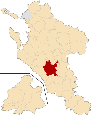
 Location of the canton of Gémozac in the Charente-Maritime department |
|
The Canton Gémozac was 2015 a French canton in the department of Charente-Maritime and in the former region Poitou-Charentes . It included 16 parishes in the arrondissement of Saintes ; its main town (French: chef-lieu ) was Gémozac . The nationwide changes in the composition of the cantons resulted in its dissolution in March 2015.
geography
The canton of Gémozac was 26,018 hectares (260.18 km 2 ) and last had 13,653 inhabitants (as of 2012), which corresponds to a population density of around 52 inhabitants per km 2 . He was on average at 38 m . Its lowest ( 5 m ) and its highest point ( 72 m ) were each in Berneuil .
Communities
The canton consisted of sixteen municipalities:
| local community | Population year | Area km² | Population density | Code INSEE | Post Code |
|---|---|---|---|---|---|
| Berneuil | 1,134 (2013) | 25.45 | 45 inhabitants / km² | 17044 | 17460 |
| Cravans | 761 (2013) | 14.72 | 52 inhabitants / km² | 17133 | 17260 |
| Gémozac | 2,802 (2013) | 31.93 | 88 inhabitants / km² | 17172 | 17260 |
| Jazennes | 492 (2013) | 10.84 | 45 inhabitants / km² | 17196 | 17260 |
| Meursac | 1,435 (2013) | 26.17 | 55 inhabitants / km² | 17232 | 17120 |
| Montpellier-de-Médillan | 637 (2013) | 14.85 | 43 inhabitants / km² | 17244 | 17260 |
| Rétaud | 1,077 (2013) | 19.92 | 54 inhabitants / km² | 17296 | 17460 |
| Rioux | 937 (2013) | 18.98 | 49 inhabitants / km² | 17298 | 17460 |
| Saint-André-de-Lidon | 1,049 (2013) | 23.83 | 44 inhabitants / km² | 17310 | 17260 |
| Saint-Quantin-de-Rançanne | 290 (2013) | 9.11 | 32 inhabitants / km² | 17388 | 17800 |
| Saint-Simon-de-Pellouaille | 608 (2013) | 8.95 | 68 inhabitants / km² | 17404 | 17260 |
| Tanzac | 311 (2013) | 11.23 | 28 inhabitants / km² | 17438 | 17260 |
| Tesson | 995 (2013) | 12.13 | 82 inhabitants / km² | 17441 | 17460 |
| Thaims | 378 (2013) | 8.74 | 43 inhabitants / km² | 17442 | 17120 |
| Villars-en-Pons | 553 (2013) | 13.32 | 42 inhabitants / km² | 17469 | 17260 |
| Virollet | 248 (2013) | 10.01 | 25 inhabitants / km² | 17479 | 17260 |