Canton of Saint-Hilaire-de-Villefranche
| Former canton of Saint-Hilaire-de-Villefranche |
|
|---|---|
| region | Poitou-Charentes |
| Department | Charente-Maritime |
| Arrondissement | Saint-Jean-d'Angély |
| main place | Saint-Hilaire-de-Villefranche |
| Dissolution date | March 29, 2015 |
| Residents | 4,881 (Jan 1, 2012) |
| Population density | 40 inhabitants / km² |
| surface | 122.75 km² |
| Communities | 10 |
| INSEE code | 1728 |
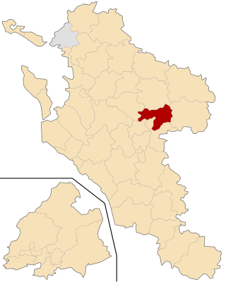
 Location of the canton of Saint-Hilaire-de-Villefranche in the Charente-Maritime department |
|
The District of Saint-Hilaire-de-Villefranche was 2015 a French canton in the department of Charente-Maritime and in the former region Poitou-Charentes . It included ten parishes in the arrondissement of Saint-Jean-d'Angély ; its main town (French: chef-lieu ) was Saint-Hilaire-de-Villefranche . The nationwide changes in the composition of the cantons resulted in its dissolution in March 2015.
geography
The canton of Saint-Hilaire-de-Villefranche was 12,275 hectares (122.75 km 2 ) and last had 4881 inhabitants, which corresponded to a population density of around 40 inhabitants per km 2 (as of 2012). It was an average of 42 m , between 13 m in La Frédière and 95 m in Saint-Hilaire-de-Villefranche .
Communities
The canton consisted of ten municipalities:
| local community | Population (as of 2013) |
Code postal | Code Insee |
|---|---|---|---|
| Aujac | 342 | 17770 | 17023 |
| Aumagne | 707 | 17770 | 17025 |
| Authon-Ébéon | 395 | 17770 | 17026 |
| Bercloux | 452 | 17770 | 17042 |
| Brizambourg | 856 | 17770 | 17070 |
| La Frédière | 81 | 17770 | 17169 |
| Juicq | 273 | 17770 | 17198 |
| Nantillé | 324 | 17770 | 17256 |
| Saint-Hilaire-de-Villefranche | 1201 | 17770 | 17344 |
| Sainte-Même | 254 | 17770 | 17374 |