Linden (Palatinate)
| coat of arms | Germany map | |
|---|---|---|

|
Coordinates: 49 ° 21 ' N , 7 ° 39' E |
|
| Basic data | ||
| State : | Rhineland-Palatinate | |
| County : | Kaiserslautern | |
| Association municipality : | Landstuhl | |
| Height : | 293 m above sea level NHN | |
| Area : | 5.1 km 2 | |
| Residents: | 1107 (Dec. 31, 2019) | |
| Population density : | 217 inhabitants per km 2 | |
| Postal code : | 66851 | |
| Area code : | 06307 | |
| License plate : | KL | |
| Community key : | 07 3 35 023 | |
| Association administration address: | Kaiserstraße 49 66849 Landstuhl |
|
| Website : | ||
| Mayoress : | Nicole Meier (FWG) | |
| Location of the local community Linden in the Kaiserslautern district | ||
Linden is a municipality in the Kaiserslautern district in Rhineland-Palatinate . It belongs to the Landstuhl Association , within which it is the third smallest local community both in terms of the number of inhabitants and in terms of area.
geography
location
The community lies on the edge of the Palatinate Forest , which merges in this area to the west into the Sickinger Höhe . The Länders-Hof, Lindener Mühle and Weiherhof residential areas also belong to Linden. Neighboring communities are - clockwise - Queidersbach , Krickenbach , Schopp , Horbach and Weselberg .
Elevations and waters
The Queidersbach , also popularly called Steinalb , flows through linden trees . The Eichköpfchen extends to the south-east of the district .
history
The place was first mentioned in a document in 1363.
From the early 16th to the end of the 18th century, the village of Linden belonged to the so-called Grand Court of the Landstuhl Lordship , which was owned by the Barons von Sickingen of the Hohenburg line.
In 1794 the left bank of the Rhine was occupied in the First Coalition War. From 1798 to 1814 Linden belonged to the canton of Landstuhl in the Donnersberg department .
From 1798 to 1814, when the Palatinate was part of the French Republic (until 1804) and then part of the Napoleonic Empire , Queidersbach was incorporated into the canton of Landstuhl in the Donnersberg department and was subordinate to the Mairie Queidersbach .
Due to the agreements made at the Congress of Vienna , the area first came to Austria in June 1815 and was ceded to the Kingdom of Bavaria in 1816 on the basis of a state treaty . Under the Bavarian administration, Linden belonged to the Landkommissariat Homburg im Rheinkreis from 1817 , from 1862 to the District Office Homburg and in 1929 moved to the District Office Kaiserslautern.
The community has been part of the Kaiserslautern district since 1939 . After the Second World War , Linden became part of the then newly formed state of Rhineland-Palatinate and the administrative district of Palatinate within the French occupation zone . In the course of the first administrative reform in Rhineland-Palatinate , the place was incorporated into the newly created community of Kaiserslautern-Süd in 1972 . On July 1, 2019, Linden moved to the Landstuhl Association .
population
Population development
The development of the population of Linden, the values from 1871 to 1987 are based on censuses:
|
|
religion
There is a Protestant and a Catholic church on site. The latter is called Herz Mariä and contains an organ made by Hugo Mayer Orgelbau from 1968.
politics
Municipal council
The municipal council in Linden consists of 16 council members, who were elected in a personalized proportional representation in the local elections on May 26, 2019 , and the honorary local mayor as chairman.
The distribution of seats in the municipal council:
| choice | SPD | CDU | FWG | BFL | total |
|---|---|---|---|---|---|
| 2019 | 2 | 2 | 12 | - | 16 seats |
| 2014 | 1 | 3 | 12 | - | 16 seats |
| 2009 | 1 | 2 | 10 | 3 | 16 seats |
| 2004 | 2 | 5 | 9 | - | 16 seats |
- FWG = Free Voting Group Linden e. V.
- BFL = Independent List Citizens for Linden e. V.
mayor
Nicole Meier (FWG) is the local mayor of Linden. In the direct election on May 26, 2019, she was elected with 87.36% of the vote and is the successor to Uwe Unnold, who did not run again after ten years in office.
coat of arms
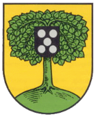
| Blazon : "A green linden tree in gold on a curved green background, the canopy of which is covered in the middle with a black shield, in it five silver balls (balls) 2: 1: 2." | |
| Justification of the coat of arms: The five silver balls refer to the former local lords, the barons of Sickingen . |
Culture
Cultural monuments
There are a total of three objects on site that are listed buildings.
nature
The part of the municipality marker east of the Queidersbach lies in the Palatinate Forest Nature Park , which in turn belongs to the Palatinate Forest-Vosges du Nord biosphere reserve .
Regular events
Every two years, on a Sunday in May, the car-free experience day cycling fun takes place in Sickinger Land and the main road is closed to motorized traffic. The only exceptions are cyclists and inline skaters from Landstuhl via Linden to Waldfischbach-Burgalben .
Sports
The local football club FV Linden existed in 1931 . On July 15, 2017, the municipality was the venue for the DM individual time trial and one day later the road race of the Rad-Bundesliga . On June 28, 2019 , the DM individual time trial of the Rad-Bundesliga took place again.
Economy and Infrastructure
traffic
Linden is located on Landesstraße 363, which runs from Landstuhl to Steinalben in a north-south direction . From this, the district road 59 branches off to the east via Krickenbach in the direction of Moosalbtal. The federal highway 270 , which connects Kaiserslautern with Pirmasens, runs east of the municipality . It is seven kilometers to the federal motorway 62 (Landstuhl – Zweibrücken) with the Bann junction. The closest train station is Schopp an der Biebermühlbahn .
tourism
The Palatinate Forest Tour, a cycle path from Kaiserslautern to Hinterweidenthal , and the Schweinstal sculpture path run through the community . In addition, a hiking trail leads through the east of the district, which is marked with a green-yellow bar and which runs from Kirchheimbolanden to Hirschthal . .
Sons and daughters of the church
- Jürgen Lutz (* 1961), soccer player
- Roger Lutz (* 1964), soccer player
Web links
- Linden parish
- Literature on linden trees in the Rhineland-Palatinate state bibliography
Individual evidence
- ↑ a b State Statistical Office of Rhineland-Palatinate - population status 2019, districts, municipalities, association communities ( help on this ).
- ↑ State Statistical Office Rhineland-Palatinate (ed.): Official directory of the municipalities and parts of the municipality. Status: January 2019 [ Version 2020 is available. ] . S. 150 (PDF; 3 MB).
- ↑ State Statistical Office Rhineland-Palatinate: My village, my city. Retrieved March 5, 2020 .
- ^ The Regional Returning Officer Rhineland-Palatinate: Municipal Council Election 2019 Linden. Retrieved November 1, 2019 .
- ^ The Regional Returning Officer Rhineland-Palatinate: 2014 Linden municipal council election. Retrieved November 1, 2019 .
- ↑ The Regional Returning Officer Rhineland-Palatinate: direct elections 2019. Accessed on November 1, 2019 (see Landstuhl, Verbandsgemeinde, seventh row of results).


