List of municipalities in the Weilheim-Schongau district
The list of municipalities in the Weilheim-Schongau district gives an overview of the 34 smallest administrative units in the district . Three of the municipalities are cities . The district town of Weilheim i.OB. is a medium-sized town , the other two, Penzberg and Schongau, are small towns . The communities of Peißenberg and Peiting are markets.
The district of Weilheim-Schongau was created in its current form as part of the Bavarian territorial reform carried out in 1972 . The district was formed from the majority of the Weilheim i.OB. and Schongau and the municipality of Ingenried , which previously belonged to the district of Marktoberdorf . The current church structure was completed in 1979.
description
The Weilheim-Schongau district can be further subdivided into seven administrative communities (VG):
- VG Altenstadt : with the communities Altenstadt , Hohenfurch , Ingenried , Schwabbruck and Schwabsoien ;
- VG Bernbeuren : with the municipalities of Bernbeuren and Burggen ;
- VG Habach : with the communities Habach , Antdorf , Obersöchering and Sindelsdorf ;
- VG Huglfing : with the communities Huglfing , Eberfing , Eglfing and Oberhausen ;
- VG Rottenbuch : with the municipalities of Rottenbuch and Böbing ;
- VG Seeshaupt : with the municipalities Seeshaupt and Iffeldorf ;
- VG Steingaden : with the communities Steingaden , Prem and Wildsteig ;
The cities of Penzberg , Schongau and Weilheim i.OB. like the markets in Peißenberg and Peiting and the municipalities of Bernried am Starnberger See , Hohenpeißenberg , Pähl , Polling , Raisting , Wessobrunn and Wielenbach are not members of an administrative community.
The district has a total area of 966.41 km 2 . The largest area within the district has the market Peiting with 75.14 km 2 , the municipality Steingaden with 64.09 km 2 , the district town of Weilheim i.OB. with 55.44 km 2 and the municipality of Wessobrunn with 51.11 km 2 . Three municipalities have an area larger than 40 km 2 , four municipalities are larger than 30 km 2 and twelve are larger than 20 km 2 , including the cities of Penzberg and Schongau . Ten municipalities have an area of over and one of under 10 km 2 . The smallest areas have the municipalities of Hohenfurch with 12.41 km 2 , Habach with 12.15 km 2 and Schwabbruck with 7.34 km 2 .
The district town of Weilheim i.OB. has the largest share of the district's population of 135,478. with 22,571 inhabitants, followed by the city of Penzberg with 16,514 inhabitants and the market Peißenberg with 12,589 inhabitants. The city of Schongau and Markt Peiting have over 12,000 and 11,000 inhabitants, respectively. Four municipalities have over 3,000 inhabitants, ten over 2,000 and eleven over 1,000 inhabitants. The four smallest municipalities in terms of population have less than 1,000 inhabitants, these are Eglfing with 1085 inhabitants, Schwabbruck with 964, Ingenried with 1089 and Prem with 896 inhabitants.
The entire district of Weilheim-Schongau has a population density of 140 inhabitants per km 2 . The cities of Penzberg with 642 inhabitants per km 2 , Schongau with 580 and Weilheim i.OB. have the greatest population density within the district. with 407, followed by Markt Peißenberg with 385. Ten communities have a population density of over 100. Five of these communities have a population density higher than the district average of 140. In the remaining 20 communities, the population density is below 100. The most sparsely populated communities are Böbing with 47, Wessobrunn with 44 and Wildsteig with 27 inhabitants per km 2 .
Legend
- Municipality : Name of the municipality or city and information about the district to which the eponymous place of the municipality belonged before the regional reform
- Subsites : Enumerated are the formerly independent municipalities of the administrative unit. The year of incorporation is also given.
- VG : Indicates membership in one of the administrative communities
- Coat of arms : coat of arms of the municipality or city
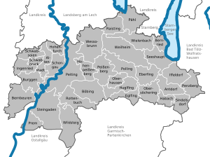
- Map : Shows the location of the municipality or city in the district
- Area : Area of the city or municipality, given in square kilometers
- Population : number of people living in the municipality or city (as of December 31, 2019)
- Population density : The population density is given, calculated on the area of the administrative unit, given in population per km 2 (as of December 31, 2019)
- Altitude : Altitude of the eponymous town or town in meters above sea level
- Image : Image from the respective municipality or city
Communities
| local community | Sub-locations | VG | coat of arms | map | surface | Residents | EW density |
height | image |
|---|---|---|---|---|---|---|---|---|---|
| Weilheim-Schongau district |  |
 |
966.41 | 135,478 | 140 |

|
|||
|
Altenstadt (belonged to the district of Schongau before the regional reform) |
Altenstadt Schwabniederhofen (1978) |
VG Altenstadt |
 |
 |
18.66 | 3,305 | 177 | 722 |

|
|
Antdorf (belonged to the district of Weilheim i.OB. before the regional reform) |
Antdorf Frauenrain (1978) |
VG Habach |
 |
 |
22.37 | 1,322 | 59 | 631 |

|
|
Bernbeuren (belonged to the district of Schongau before the regional reform) |
Bernbeuren | VG Bernbeuren |
 |
 |
41.69 | 2,416 | 58 | 773 |

|
|
Bernried am Starnberger See (before the regional reform it belonged to the district of Weilheim i.OB.) |
Bernried on Lake Starnberg |  |
 |
13.79 | 2,348 | 170 | 597 |
 
|
|
|
Böbing (belonged to the district of Schongau before the regional reform) |
Boing | VG Rottenbuch |
 |
 |
40.32 | 1,884 | 47 | 744 |

|
|
Burggen (belonged to the district of Schongau before the regional reform) |
Burggen Tannenberg |
VG Bernbeuren |
 |
 |
24.94 | 1,698 | 68 | 746 |

|
|
Eberfing (belonged to the district of Weilheim i.OB. before the regional reform) |
Eberfing Arnried |
VG Huglfing |
 |
 |
25.93 | 1,461 | 56 | 610 |

|
|
Eglfing (belonged to the district of Weilheim i.OB. before the regional reform) |
Eglfing | VG Huglfing |
 |
 |
16.16 | 1,085 | 67 | 656 |

|
|
Habach (belonged to the district of Weilheim i.OB. before the regional reform) |
Habach | VG Habach |
 |
 |
12.15 | 1,161 | 96 | 649 |

|
|
Hohenfurch (belonged to the district of Schongau before the regional reform) |
Hohenfurch | VG Altenstadt |
 |
 |
12.41 | 1,682 | 136 | 699 |

|
|
Hohenpeißenberg (belonged to the district of Schongau before the regional reform) |
Hohenpeißenberg Ammerhöfe (1978; only part of the municipality) |
 |
 |
20.44 | 3,853 | 189 | 780 |
 
|
|
|
Huglfing (belonged to the district of Weilheim i.OB. before the regional reform) |
Huglfing | VG Huglfing |
 |
 |
24.36 | 2,884 | 118 | 606 |

|
|
Iffeldorf (belonged to the district of Weilheim i.OB. before the regional reform) |
Iffeldorf | VG Seeshaupt |
 |
 |
27.61 | 2,682 | 97 | 603 |

|
|
Ingenried (belonged to the district of Marktoberdorf before the regional reform) |
Ingenried | VG Altenstadt |
 |
 |
17.45 | 1,089 | 62 | 802 |

|
|
Oberhausen (belonged to the district of Weilheim i.OB. before the regional reform) |
Oberhausen Ammerhöfe (1978; only part of the municipality) |
VG Huglfing |
 |
 |
14.91 | 2,097 | 141 | 611 |

|
|
Obersöchering (belonged to the district of Weilheim i.OB. before the regional reform) |
Obersöchering | VG Habach |
 |
 |
24.27 | 1,529 | 63 | 672 |

|
|
Pähl (belonged to the district of Weilheim i.OB. before the regional reform) |
Pähl fishing (1978) |
 |
 |
32.04 | 2,446 | 76 | 591 |

|
|
|
Peißenberg (market) (belonged to the district of Weilheim i.OB. before the regional reform) |
Peißenberg Ammerhöfe (1978; only part of the municipality) |
 |
 |
32.69 | 12,589 | 385 | 584 |

|
|
|
Peiting (market) (belonged to the district of Schongau before the regional reform) |
Peiting Birkland (1976) |
 |
 |
75.14 | 11,425 | 152 | 718 |

|
|
|
Penzberg (town) (belonged to the district of Weilheim i.OB. before the regional reform) |
Penzberg |  |
 |
25.73 | 16,514 | 642 | 596 |

|
|
|
Polling (belonged to the district of Weilheim i.OB. before the regional reform) |
Polling Etting (1978) Oderding (1978) |
 |
 |
29.22 | 3,539 | 121 | 567 |

|
|
|
Prem (belonged to the district of Schongau before the regional reform) |
Prem | VG Steingaden |
 |
 |
15.91 | 896 | 56 | 749 |

|
|
Raisting (belonged to the district of Weilheim i.OB. before the regional reform) |
Raising |  |
 |
21.98 | 2,328 | 106 | 553 |

|
|
|
Rottenbuch (belonged to the district of Schongau before the regional reform) |
Rottenbuch Schönberg (1978) |
VG Rottenbuch |
 |
 |
31.45 | 1,797 | 57 | 763 |

|
|
Schongau (city) (belonged to the district of Schongau before the regional reform) |
Schongau |  |
 |
21.35 | 12,377 | 580 | 710 |

|
|
|
Schwabbruck (belonged to the district of Schongau before the regional reform) |
Schwabbruck | VG Altenstadt |
 |
 |
7.34 | 964 | 131 | 732 |

|
|
Schwabsoien (belonged to the district of Schongau before the regional reform) |
Schwabsoien Sachsenried (1978) |
VG Altenstadt |
 |
 |
17.02 | 1,394 | 82 | 746 |

|
|
Seeshaupt (belonged to the district of Weilheim i.OB. before the regional reform) |
Seeshaupt Magnetsried (1978) |
VG Seeshaupt |
 |
29.97 | 3,253 | 109 | 595 |

|
|
|
Sindelsdorf (belonged to the district of Weilheim i.OB. before the regional reform) |
Sindelsdorf | VG Habach |
 |
 |
17.5 | 1,214 | 69 | 609 |

|
|
Steingaden (belonged to the district of Schongau before the regional reform) |
Steingaden Fronreit Lauterbach Urspring |
VG Steingaden |
 |
 |
64.09 | 2,888 | 45 | 763 |

|
|
Weilheim i.OB. (District town) (belonged to the district of Weilheim i.OB. before the regional reform) |
Weilheim i.OB. Deutenhausen (1978) Unterhausen (1978) |
 |
 |
55.44 | 22,571 | 407 | 563 |

|
|
|
Wessobrunn (belonged to the district of Weilheim i.OB. before the regional reform) |
Wessobrunn Forst (1978) Haid (1978) |
 |
 |
51.11 | 2,269 | 44 | 702 |
 
|
|
|
Wielenbach (belonged to the district of Weilheim i.OB. before the regional reform) |
Wielenbach Haunshofen (1978) |
 |
 |
33.01 | 3,208 | 97 | 554 |

|
|
|
Wildsteig (belonged to the district of Schongau before the regional reform) |
Wildsteig | VG Steingaden |
 |
 |
47.73 | 1.310 | 27 | 882 |

|
See also
Individual evidence
- ↑ "Data 2" sheet, Statistical Report A1200C 202041 Population of the municipalities, districts and administrative districts 1st quarter 2020 (population based on the 2011 census) ( help ).
- ↑ "Data 2" sheet, Statistical Report A1200C 202041 Population of the municipalities, districts and administrative districts 1st quarter 2020 (population based on the 2011 census) ( help ).
- ↑ BayernViewer of the Bavarian Surveying Administration
