
Alpirsbach
| coat of arms | Germany map | |
|---|---|---|

|
Coordinates: 48 ° 21 ' N , 8 ° 24' E |
|
| Basic data | ||
| State : | Baden-Württemberg | |
| Administrative region : | Karlsruhe | |
| County : | Freudenstadt | |
| Height : | 441 m above sea level NHN | |
| Area : | 64.55 km 2 | |
| Residents: | 6304 (December 31, 2018) | |
| Population density : | 98 inhabitants per km 2 | |
| Postal code : | 72275 | |
| Area code : | 07444 | |
| License plate : | FDS, HCH , HOR, WOL | |
| Community key : | 08 2 37 002 | |
| LOCODE : | DE ASB | |
City administration address : |
Marktplatz 2 72275 Alpirsbach |
|
| Website : | ||
| Mayor : | Michael E. Pfaff (independent) | |
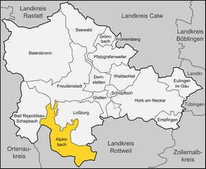
| Location of the town of Alpirsbach in the Freudenstadt district | ||
  |
||

Alpirsbach [ ˈalpɪrsbax ] is a town in the Freudenstadt district in Baden-Württemberg . It belongs to the Northern Black Forest region .
geography
Alpirsbach is located in the upper Kinzig valley in the Swabian part of the Black Forest .
City structure
The town of Alpirsbach consists of the main town of Alpirsbach (including the municipality of Rötenbach, which has been united with Alpirsbach since 1938) and five districts of Ehlenbogen , Reinerzau , Peterzell, Reutin and Römlinsdorf, which include 77 other villages, hamlets, farms, Zinken and houses.
The districts are spatially identical to the earlier communities of the same name. With the exception of the districts of Alpirsbach and Rötenbach, localities within the meaning of the Baden-Württemberg municipal code, each with their own local council and mayor as their chairman, are set up in all districts .
The Sulzberghof desert is located in the Ehlenbogen district and the Heimbach desert in the Römlinsdorf district.
history
Until the 18th century
Alpirsbach emerged as a settlement around the eponymous 1095 by Bishop Gebhard III. Alpirsbach Monastery consecrated by Constance, a Zähringer . The name Alpirsbach is probably related to Adalbert von Zollern , one of the founders of the monastery. The Alpirsbach property was also a locus , which means that there was already a settlement on it. It was found by the monks and must have existed for some time, which is also indicated by the information that the three founders owned the predium Alpirspach by virtue of inheritance law. The -bach name Alpirsbach has the personal name Adalbirn in the foreground . It was ultimately also taken over by the monastery. With the abolition of the Benedictine abbey due to the Reformation , Alpirsbach became the seat of a Wuerttemberg monastery office , which led to the growth of the settlement surrounding the Alpirsbach monastery, because craftsmen, officials and guild representatives settled here.
Mining (gold, silver and cobalt) led to prosperity in the community since the late 17th century.
19th and 20th centuries
After the establishment of the Kingdom of Württemberg , the monastery office was abolished in 1810 and Alpirsbach came to the Oberamt Oberndorf . The departure of the authorities also led to a decline in prosperity and population. In the middle of the 19th century, poverty led to increased emigration, especially to Wisconsin . In 1861 the first volunteer fire brigade in the entire Oberndorf Oberamt was formed in Alpirsbach . After the situation had improved, King Karl von Württemberg granted the municipality of Alpirsbach town rights in 1869 . On November 3, 1886, Alpirsbach had a connection to the rail network of the Württemberg railway through the Kinzig Valley Railway . The municipal hospital with twelve beds was opened in May 1897.
The administrative reform of April 25, 1938 led to membership in the Freudenstadt district . On May 3, 1938, the neighboring town of Rötenbach was incorporated. After the Second World War, the city of Alpirsbach fell into the French zone of occupation and thus came to the newly founded state of Württemberg-Hohenzollern in 1947 , which was incorporated into the state of Baden-Württemberg in 1952.
A flood in December 1947 caused considerable damage.
religion
The Reformation was introduced in Alpirsbach in 1535. The Alpirsbach monastery was abolished. Although the monastery came under Roman Catholic rule again during the so-called interim from 1548 to 1552 , the new Protestant denomination was then able to establish itself permanently.
In the former Benedictine abbey, whose most famous evangelical abbot was Johann Albrecht Bengel , evangelical Christians have been meeting since 1933 as Church Work Alpirsbach to revive worship, praise, adoration and intercession in the evangelical church. The meaning of the church should be considered and the church and its members should turn from the renewal of worship to a renewal of church and society. They cultivate the choral prayer , which is largely unknown in the Protestant Church today, and the Gregorian chant , which they want to regain for the Protestant liturgy .
The Catholic parish of St. Benedict uses the former refectory of the monastery as its church room. The altar wall was designed by Wilhelm Geyer .
Population development

Population of Alpirsbach for each area:
|
|
|
Incorporations
- 1938: Incorporation of Rötenbach
- January 1, 1971: incorporation of Reutin (with ditches)
- April 1, 1974: The town of Alpirsbach is merged with Ehlenbogen, Reinerzau, Peterzell and Römlinsdorf to form the new municipality of Alpirsbach
politics

Municipal council
The local elections on May 25, 2019 led to the following result:
| SPD / Greens | 18.9% | 3 seats |
| FWV | 71.5% 3 | 5 seats |
| UBL 1 | 4 seats | |
| ZfA 2 | 4 seats | |
| List of women | 9.5% | 2 seats |
mayor
- 1819–1833: Johann Georg Faßnacht (first elected mayor)
- ???? - 1848: Köstlin
- 1848-1850: Schliz
- 1857–1882: Albert Heinzelmann (first town school of Alpirsbach)
- 1882–1889:
- 1889–1895: Ernst Gottlob Schöck
- 1895–1918: Wilhelm Rieker
- 1918–1926: Wilhelm Schwarz
- 1926–1933: Friedrich Reichert
- 1933–1945: Otto Rommel ( NSDAP , then mayor of Holzgerlingen )
- 1945–1948: Robert Faulhaber
- 1949–1967: Otto Müller (previously 1938–1945 mayor of Holzgerlingen )
- 1967–1974: Hans Volle (CDU, then district administrator in Tuttlingen )
- 1974–2000: Peter Dombrowsky ( CDU , then District Administrator in Freudenstadt )
- 2000–2008: Roland Wentsch (independent)
- 2008-2016: Reiner Ullrich ( SPD )
- since 2016: Michael E. Pfaff (independent)
On April 24, 2016, Michael E. Pfaff, a non-party graduate in administrative management from Alpirsbach, was elected mayor with 28.5% of the votes in the second ballot. He prevailed against the incumbent Reiner Ulrich (21.5%, SPD) as well as against Andreas Bombel (25.3%, CDU) and Matthias Auch (24.6%, CDU).
coat of arms
The blazon of the coat of arms reads: "In blue a growing, right-facing golden abbot's staff."
Town twinning
-
 Neuville-sur-Saône near Lyon, France
 -
Cultural partnership with Cluny / Burgundy
Economy and Infrastructure
traffic

The city is connected to Freudenstadt and Offenburg every hour on weekdays via the Kinzig Valley Railway and belongs to the Freudenstadt District Transport Association . With connections in Freudenstadt Hbf, further destinations in the Black Forest can be reached via the Murgtalbahn and Gäubahn .
Alpirsbach is connected to the national road network via the federal highways 294 ( Bretten - Freiburg im Breisgau ) and 462 ( Rastatt - Rottweil ).
Established businesses
The Alpirsbacher Klosterbräu brewery, founded in 1877, is the best-known Alpirsbach company. The largest employer is Saier Holding GmbH in the Alpirsbach district of Peterzell.
Educational institutions
In addition to a Pro high school and a junior high school there in Alpirsbach one together with Schiltach and Schenkenzell operated Werkrealschule ( Werkrealschule Upper Kinzigtal ) and two primary schools . There are also five municipal, two Protestant and one Roman Catholic kindergartens .
Culture and sights
Alpirsbach has an extensive cultural program with concerts, exhibitions and festivals. The Black Forest landscape of the upper Kinzig valley is also worth seeing .
Alpirsbach is located on the Kinzig valley Jakobusweg , which leads from Lossburg to Schutterwald , as well as on the Ostweg long-distance hiking trail , both of which touch many sights. Alpirsbach is also the starting point and end point of the Black Forest cross-way from Gengenbach to Alpirsbach .
Museums

- Former Benedictine monastery Alpirsbach (since 1095) with museum
- Gallery with changing exhibitions
- City History Museum
- Alpirsbacher Klosterbräu with brewery museum
- Alpirsbacher glass blowing
- Show confectionery
- Historical print shop - The Alpirsbacher Offizin
building
- Historic city center with many half-timbered houses
- Historic tanner's house from 1783, renovated in 2012
Natural sights
- Kleine Kinzig dam of the Kleine Kinzig water supply with Black Forest water path
movie theater
- Subiaco Kinos e. V .: Multiple award-winning art house cinema in the monastery (50 seats) with additional locations in Schramberg (99 seats) and Freudenstadt (70 seats). In the summer months, open-air performances take place in the Kreuzgarten of the monastery and at various places in the area.
Personalities
Honorary citizen
- 1899, Christian Gaiser, senior building officer in Stuttgart
- 1922, Friedrich Widmann, architect and benefactor of the city.
- 1937, Friedrich Preuninger, Rötenbacher Schultheiss for 38 years
- 1939, Max Kaupp, city doctor
- 1978, Georg A. Brenner, pharmaceuticals manufacturer and great patron of the city
- 1984, Walter Traub, school principal, city councilor, city historian and co-founder of the Heimatverein as well as initiator of the Museum of City History in Alpirsbach
sons and daughters of the town
- Hermann Knapp (1801–1859), member of the second chamber of the Württemberg state parliament, director of the royal study council in Stuttgart
- Emil Buehler (1899–1983), aeronautical engineer
- Otto Eisenmann (1913–2002), politician ( DP , FDP ), Member of the Bundestag , Member of the Bundestag ( Schleswig-Holstein ), Minister for Labor, Social Affairs and Displaced Persons in Schleswig-Holstein.
- Peter Weidenbach (* 1934), Forest Director
- Else Schwenk-Anger (* 1936), children's book author and publisher
- Heiner Scheffold (* 1962), politician, district administrator of the Alb-Donau district
- Frank Faber real name Frank Schmitt (1966–2013), cook and writer
- Michaela Fuchs (1969–2018), disabled athlete
- Marcus Rominger (* 1972), handball goalkeeper and architect
- Oliver Thomas (* 1977), pop singer
Sports
The Black Forest Ultra Bike Marathon takes place in Alpirsbach every year . It is one of the most difficult cycling marathons in Germany. Over a distance of 230 km, 4000 meters of altitude must be overcome.
There is also a gymnastics club in Alpirsbach, whose handball team has been playing in the district league of the South Baden handball association since the 2014/2015 season, after having been relegated to the state league after seven years of membership. There is also a sports club whose first men's soccer team is active in the district league A of the Württemberg soccer association.
literature
- Karl-Martin Hummel (Ed.): Kleines Alpirsbacher Heimatbuch , 1969
- City of Alpirsbach (Ed.): Alpirsbach - a home book , 2011
Web links
- City of Alpirsbach
- Alpirsbach at LEO-BW
- The interactive story book about the Alpirsbach rafting path
- Alpirsbacher Offizin - historical printing house
Individual evidence
- ↑ State Statistical Office Baden-Württemberg - Population by nationality and gender on December 31, 2018 (CSV file) ( help on this ).
-
^ Sources for the urban structure section:
Das Land Baden-Württemberg. Official description by district and municipality. Volume V: Karlsruhe District Kohlhammer, Stuttgart 1976, ISBN 3-17-002542-2 . P. 603–607
Main statutes of the city of Alpirsbach from September 9, 2003 (PDF; accessed on August 20, 2008) - ^ Johannes Janssen : History of the German people since the end of the Middle Ages . Vol. 3: General conditions of the German people from the outcome of the social revolution to the so-called Augsburg religious peace of 1555. The political-church revolution of the princes and cities and its consequences for people and empire up to the so-called Augsburg religious peace of 1555 . Herder, Freiburg, 9th to 12th ed. 1883, p. 282.
- ^ Federal Statistical Office (ed.): Historical municipality directory for the Federal Republic of Germany. Name, border and key number changes in municipalities, counties and administrative districts from May 27, 1970 to December 31, 1982 . W. Kohlhammer, Stuttgart / Mainz 1983, ISBN 3-17-003263-1 , p. 528 .
- ^ Federal Statistical Office (ed.): Historical municipality directory for the Federal Republic of Germany. Name, border and key number changes in municipalities, counties and administrative districts from May 27, 1970 to December 31, 1982 . W. Kohlhammer, Stuttgart / Mainz 1983, ISBN 3-17-003263-1 , p. 492 .
- ↑ Baden-Württemberg State Statistical Office ( page no longer available , search in web archives ) Info: The link was automatically marked as defective. Please check the link according to the instructions and then remove this notice.
- ↑ Schwarzwälder-Bote, May 26, 2014
- ↑ Schwarzwälder Bote, Oberndorf, Germany: Alpirsbach: Michael E. Pfaff wins the home victory - Black Forest Bote. In: www.schwarzwaelder-bote.de. Retrieved June 17, 2016 .
