Pietrapertosa
| Pietrapertosa | ||
|---|---|---|

|
|
|
| Country | Italy | |
| region | Basilicata | |
| province | Potenza (PZ) | |
| Coordinates | 40 ° 31 ' N , 16 ° 4' E | |
| height | 1088 m slm | |
| surface | 67 km² | |
| Residents | 958 (Dec. 31, 2019) | |
| Population density | 14 inhabitants / km² | |
| Post Code | 85010 | |
| prefix | 0971 | |
| ISTAT number | 076061 | |
| Popular name | Pietrapertosani | |
| Patron saint | James the Elder | |
| Website | Pietrapertosa | |
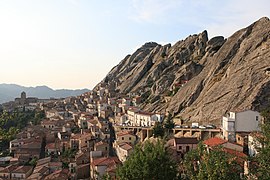
 Panorama of Pietrapertosa |
||
Pietrapertosa is a southern Italian municipality ( comune ) with 958 inhabitants (as of December 31, 2019) in the province of Potenza in Basilicata . The municipality is located about 25.5 kilometers east-southeast of Potenza at the Parco naturale di Gallipoli Cognato - Piccole Dolomiti Lucane , belongs to the Comunità Montana Alto Basento and borders directly on the province of Matera . Pietrapertosa is a member of the I borghi più belli d'Italia association (The Most Beautiful Places in Italy).
history
According to later ancient authors, the area was in the 8th century BC. Settled by Pelasger .
traffic
On the northern edge of the municipality, Strada Statale 407 Basentana runs from Potenza to Metaponto .
Web links
Commons : Pietrapertosa - collection of images, videos and audio files
Individual evidence
- ↑ Statistiche demografiche ISTAT. Monthly population statistics of the Istituto Nazionale di Statistica , as of December 31 of 2019.
- ^ I borghi più belli d'Italia (official website), accessed on May 2, 2017 (Italian)

