Villa del Prado (Madrid)
| Municipality of Villa de Prado | ||
|---|---|---|
| coat of arms | Map of Spain | |

|
|
|
| Basic data | ||
| Autonomous Community : | Madrid | |
| Province : | Madrid | |
| Coordinates | 40 ° 17 ′ N , 4 ° 18 ′ W | |
| Height : | 410 msnm | |
| Area : | 78.42 km² | |
| Residents : | 6,520 (Jan 1, 2019) | |
| Population density : | 83.14 inhabitants / km² | |
| Postal code : | 28630 | |
| Municipality number ( INE ): | 28171 | |
| administration | ||
| Website : | www.villadelprado.es | |
| Location of the municipality | ||

|
||
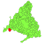
The municipality of Villa de Prado is located around 60 kilometers west of Madrid , in the far west of the autonomous community of Madrid . It is located in the Alberche valley , which forms the border with the province of Toledo . Wine and fruit growing are the main focus of economic activity.
history
The origins lie in the Moorish castle Alhamin ( AI-fahmin ), one of the many border festivals between the Christian and Muslim areas on the Iberian Peninsula, next to which a small settlement developed.
The area was recaptured for the Christians by King Alfonso VI in 1078 and subsequently became part of the Toledo diocese . In the protection of the fortress, Christian cattle farmers from the north settled on the fertile pastures (Spanish prado ) along the Alberch. After 1436 the fortress and the settlement came under the rule of the House of Luna and later to the Mendozas, who elevated the settlement to a community. The rule of the Mendozas did not end until the beginning of the 19th century when Spain was occupied by the French and the Cortes of Cádiz removed nobility privileges.
In the 17th century, the economic boom in agriculture initially led to the emergence of a leather processing industry. As the century progressed, Villa del Prado, like all of Spain, suffered a gradual economic decline that lasted until the 18th century.
The 19th century remained restless even after the end of the French occupation. During the First Carlist War , supporters of Don Carlos, a brother of King Ferdinand VII, sought refuge and Villa del Prado in the area. The place was subsequently looted and pillaged and in the second half of the 19th century, renewed epidemics led to further population losses.
A few kilometers south of the village there was a field airfield on the "Finca de las Migueras" during the Spanish Civil War , which was also used by parts of the German Condor Legion at times. At the end of 1936 and the beginning of February 1937, the 2nd squadron of Jagdgruppe 88 (2 / J88) was located here again .
Attractions
The parish church with its granite bell tower dates from the 15th and 16th centuries. Century. In addition to this, there are three interesting hermitages and the 17th century town hall on the main square, the Plaza Mayor .
The local patronage festival in honor of Nuestra Señora de La Poveda takes place every year from September 7th to 13th.
Individual evidence
- ↑ Cifras oficiales de población resultantes de la revisión del Padrón municipal a 1 de enero . Population statistics from the Instituto Nacional de Estadística (population update).
