
Mount Lemmon: Difference between revisions
Reverted to revision 939510552 by 65.182.144.2 (talk): Trivial (TW) |
images - one gallery, shift other |
||
| Line 29: | Line 29: | ||
}} |
}} |
||
[[File:Backside.jpg|thumb|Unpaved road on the north or "backside" of Mount Lemmon]] |
[[File:Backside.jpg|thumb|Unpaved road on the north or "backside" of Mount Lemmon]] |
||
| ⚫ | [[File:SkyIslandPkwy.JPG|Catalina Highway climbing Mount LemmonFile:Stereograph_-Mount_Lemmon_Highway.jpg|thumb|upright|This is a stereograph of the Mt Lemmon Highway near Windy Point Vista. Once clicked on, position your eyes about 15 inches from your monitor, and relax your vision so that you are looking at infinity far behind your monitor. The two images will eventually meld into one three dimensional image.]] |
||
'''Mount Lemmon''', with a summit elevation of {{convert|9,159|ft|0}},<ref name="ngs"/> is the highest point in the [[Santa Catalina Mountains]]. It is located in the [[Coronado National Forest]] north of [[Tucson, Arizona]], United States. Mount Lemmon was named for [[botany|botanist]] [[Sara Plummer Lemmon]], who trekked to the top of the mountain with her husband and E. O. Stratton, a local rancher, by horse and foot in 1881.<ref name="calbeat">{{cite web |url=http://www.californiabeat.org/2009/05/27/california-beat-hero-sara-plummer-lemmon |title=California Beat Hero: Sara Plummer Lemmon |date=May 27, 2009 |publisher=CaliforniaBeat.org |accessdate=2014-02-07}}</ref><ref>{{cite web |author=Lemmon, J.G. |title=A botanical wedding trip |work=Californian vol. 5. no. 24. |pages=517–525 |year=1881 |url=http://www.nybg.org/files/The_Californian_BotanicalWeddingTrip.pdf |url-status=dead |archiveurl=https://web.archive.org/web/20150402092321/http://www.nybg.org/files/The_Californian_BotanicalWeddingTrip.pdf |archivedate=April 2, 2015 |df=mdy-all }}</ref> It is reported that [[Mount Lemmon Ski Valley]], on the mountain's northeastern side, receives {{convert|200|in|cm|0}} of snow annually.<ref>{{cite web |url=http://www.skitown.com/resortguide/stats.cfm/az02/Mt.Lemmon |title=Mt. Lemmon Ski Valley |publisher=SkiTown.com |accessdate=2014-02-07}}</ref> |
'''Mount Lemmon''', with a summit elevation of {{convert|9,159|ft|0}},<ref name="ngs"/> is the highest point in the [[Santa Catalina Mountains]]. It is located in the [[Coronado National Forest]] north of [[Tucson, Arizona]], United States. Mount Lemmon was named for [[botany|botanist]] [[Sara Plummer Lemmon]], who trekked to the top of the mountain with her husband and E. O. Stratton, a local rancher, by horse and foot in 1881.<ref name="calbeat">{{cite web |url=http://www.californiabeat.org/2009/05/27/california-beat-hero-sara-plummer-lemmon |title=California Beat Hero: Sara Plummer Lemmon |date=May 27, 2009 |publisher=CaliforniaBeat.org |accessdate=2014-02-07}}</ref><ref>{{cite web |author=Lemmon, J.G. |title=A botanical wedding trip |work=Californian vol. 5. no. 24. |pages=517–525 |year=1881 |url=http://www.nybg.org/files/The_Californian_BotanicalWeddingTrip.pdf |url-status=dead |archiveurl=https://web.archive.org/web/20150402092321/http://www.nybg.org/files/The_Californian_BotanicalWeddingTrip.pdf |archivedate=April 2, 2015 |df=mdy-all }}</ref> It is reported that [[Mount Lemmon Ski Valley]], on the mountain's northeastern side, receives {{convert|200|in|cm|0}} of snow annually.<ref>{{cite web |url=http://www.skitown.com/resortguide/stats.cfm/az02/Mt.Lemmon |title=Mt. Lemmon Ski Valley |publisher=SkiTown.com |accessdate=2014-02-07}}</ref> |
||
| Line 52: | Line 53: | ||
==Back side== |
==Back side== |
||
| ⚫ | |||
| ⚫ | |||
| ⚫ | |||
| ⚫ | |||
| ⚫ | |||
| ⚫ | [[File:Stereograph_-Mount_Lemmon_Highway.jpg|thumb|This is a stereograph of the Mt Lemmon Highway near Windy Point Vista. Once clicked on, position your eyes about 15 inches from your monitor, and relax your vision so that you are looking at infinity far behind your monitor. The two images will eventually meld into one three dimensional image.]] |
||
An unpaved road to the summit on the north side of Mount Lemmon starts in [[Oracle, Arizona|Oracle]], which is on [[Arizona State Route 77|Arizona Route 77]] north of Tucson. It offers a secondary route to the top. This route is popular with off-road 4x4 drivers and with off-road or dual-purpose motorcyclists. This road ends at the Catalina Highway near Loma Linda. Before the Catalina Highway was built it was the only route up the mountain.<ref>{{cite web |title=Backway to Mount Lemmon |url=http://www.trails.com/tcatalog_trail.aspx?trailid=XFT002-067 |publisher=Trails.com |accessdate=2012-08-28}}</ref> |
An unpaved road to the summit on the north side of Mount Lemmon starts in [[Oracle, Arizona|Oracle]], which is on [[Arizona State Route 77|Arizona Route 77]] north of Tucson. It offers a secondary route to the top. This route is popular with off-road 4x4 drivers and with off-road or dual-purpose motorcyclists. This road ends at the Catalina Highway near Loma Linda. Before the Catalina Highway was built it was the only route up the mountain.<ref>{{cite web |title=Backway to Mount Lemmon |url=http://www.trails.com/tcatalog_trail.aspx?trailid=XFT002-067 |publisher=Trails.com |accessdate=2012-08-28}}</ref> |
||
| ⚫ | |||
| ⚫ | |||
| ⚫ | |||
| ⚫ | |||
| ⚫ | |||
| ⚫ | |||
<gallery mode="packed" heights="240px" style="float:right"> |
|||
| ⚫ | |||
File:SkyIslandPkwy.JPG|Catalina Highway climbing Mount Lemmon |
|||
| ⚫ | |||
</gallery> |
|||
| ⚫ | |||
File:(140) Mountlemmonobservatory.JPG|View of the telescopes on Mount Lemmon |
File:(140) Mountlemmonobservatory.JPG|View of the telescopes on Mount Lemmon |
||
File:Oracle AZ Mt Lemmon.JPG|View of Mount Lemmon from Oracle, AZ |
File:Oracle AZ Mt Lemmon.JPG|View of Mount Lemmon from Oracle, AZ |
||
</gallery> |
</gallery> |
||
{{clear right}} |
|||
| ⚫ | |||
| ⚫ | |||
==See also== |
==See also== |
||
Revision as of 23:18, 9 April 2020
| Mount Lemmon | |
|---|---|
 View of Mount Lemmon from the western side of Tucson | |
| Highest point | |
| Elevation | 9,171 ft (2,795 m) NAVD 88[1] |
| Prominence | 5,157 ft (1,572 m)[2] |
| Listing |
|
| Coordinates | 32°26′35″N 110°47′19″W / 32.442961983°N 110.788478444°W[1] |
| Geography | |
 Mount Lemmon | |
| Location | Tucson, Pima County, Arizona, U.S. |
| Parent range | Santa Catalina Mountains |
| Topo map | USGS Mount Lemmon |
| Climbing | |
| Easiest route | Catalina Highway |


Mount Lemmon, with a summit elevation of 9,159 feet (2,792 m),[1] is the highest point in the Santa Catalina Mountains. It is located in the Coronado National Forest north of Tucson, Arizona, United States. Mount Lemmon was named for botanist Sara Plummer Lemmon, who trekked to the top of the mountain with her husband and E. O. Stratton, a local rancher, by horse and foot in 1881.[3][4] It is reported that Mount Lemmon Ski Valley, on the mountain's northeastern side, receives 200 inches (508 cm) of snow annually.[5]
Summerhaven
Summerhaven is a small town near the top of the mountain. It is a summer residence for many but there are some year round residents. There are many small cabins most of which were rebuilt after the Aspen Fire of July 2003.[6]
Mount Lemmon Station Observatory
At the peak is the Mount Lemmon Observatory, which was formerly the site of a USAF radar base of the Air Defense Command,[7] and the building that formerly housed a military emergency radar tracking station for landing the Space Shuttle at White Sands Missile Range. Although the United States military had a presence on the mountain for several decades all their facilities have been abandoned and were given to the United States Forest Service. The area and buildings that makes up the Mount Lemmon Station Observatory are leased from the Forest Service by the University of Arizona. The telescopes on the mountain are still used for astronomical research today by organizations such as the Catalina Sky Survey, the Mount Lemmon Sky Center,[8] the University of Arizona Astronomy Camp program,[9] the University of Arizona, and the University of Minnesota. The educational resources at the top of the mountain make it a unique research and teaching destination.
Catalina Highway
The Catalina Highway, also called the Mount Lemmon Highway, as well as the Hitchcock Highway (after Frank Harris Hitchcock) runs up the Santa Catalina Mountains from the east side of Tucson up to Summerhaven, at the top of Mt. Lemmon. The beautiful, curving road is a favorite drive for tourists, for locals escaping summer's heat and cyclists, and has been recently designated as the Sky Island Parkway, part of the US National Scenic Byway system.[10]
2010 saw the inaugural running of the Mount Lemmon Marathon.[11]
Climate
The summit of the mountain is approximately twenty degrees cooler than the base. Therefore, large amounts of snow fall during the winter months, making it a cool escape and popular tourist attraction for Tucson and Phoenix inhabitants.
Fees and permits
Catalina Highway charges tolls for parking, camping, and hiking. However, the tolls are only officially charged for people who are camping. Tolls for other events, such as hiking, parking, or grilling, are a part of the honor system. Park rangers will not check for toll payments unless someone is using the park campgrounds. Anyone wishing to sightsee or travel to Summerhaven are not subjected to paying tolls.[citation needed]
Back side
An unpaved road to the summit on the north side of Mount Lemmon starts in Oracle, which is on Arizona Route 77 north of Tucson. It offers a secondary route to the top. This route is popular with off-road 4x4 drivers and with off-road or dual-purpose motorcyclists. This road ends at the Catalina Highway near Loma Linda. Before the Catalina Highway was built it was the only route up the mountain.[12]
-
 Hoodoos, Santa Catalina Mountains
 -
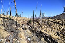 Remnants of the 2003 Aspen Fire
 -
 Mount Lemmon Ski Valley
 -
 Cabins atop Mt Lemmon in Summerhaven
 -
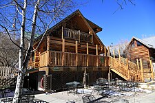 Summerhaven, Cookie Cabin
 -
 View of the telescopes on Mount Lemmon
 -
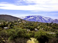 View of Mount Lemmon from Oracle, AZ


_Mountlemmonobservatory.JPG)

Other Names
The peak is called (O'odham: Babad Doʼag) but this is not widely known or used other then a few people.
See also
- List of Ultras of the United States
- Mount Lemmon Observatory
- Mount Lemmon Ski Valley
- Mount Lemmon Survey
References
- ^ a b c "Catalina 2 Reset". NGS Data Sheet. National Geodetic Survey, National Oceanic and Atmospheric Administration, United States Department of Commerce. Retrieved August 18, 2016.
- ^ "Mount Lemmon, Arizona". Peakbagger.com. Retrieved February 7, 2014.
- ^ "California Beat Hero: Sara Plummer Lemmon". CaliforniaBeat.org. May 27, 2009. Retrieved February 7, 2014.
- ^ Lemmon, J.G. (1881). "A botanical wedding trip" (PDF). Californian vol. 5. no. 24. pp. 517–525. Archived from the original (PDF) on April 2, 2015.
- ^ "Mt. Lemmon Ski Valley". SkiTown.com. Retrieved February 7, 2014.
- ^ Faherty, John. "Town of Summerhaven back after devastating fire". AZ Central. Retrieved August 28, 2012.
- ^ "Air Defense Radar Stations". Radomes Inc. Retrieved August 28, 2012.
- ^ "SkyCenter". University of Arizona. Retrieved August 18, 2016.
- ^ "Astronomy Camp". University of Arizona SkyCenter. Retrieved August 18, 2016.
- ^ "Name change to Sky Island Parkway". Arizona Dept. of Transportation. Retrieved July 14, 2010.
- ^ Lacey, Marc (October 17, 2010). "A Finish Line With a Real High: 8,000 Feet". New York Times. Retrieved October 28, 2010.
- ^ "Backway to Mount Lemmon". Trails.com. Retrieved August 28, 2012.
External links
- "Mount Lemmon". Geographic Names Information System. United States Geological Survey, United States Department of the Interior.
- "Mt. Lemmon". SummitPost.org.
- NOAA "Mount Lemmon Forecast".
- David Leighton (January 5, 2015). "Street Smarts: Highway, mountain named for botanist". Arizona Daily Star.