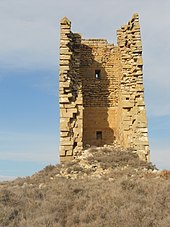
Alcalá de Gurrea
| Alcalá de Gurrea municipality | ||
|---|---|---|
| coat of arms | Map of Spain | |

|
|
|
| Basic data | ||
| Autonomous Community : | Aragon | |
| Province : | Huesca | |
| Comarca : | Hoya de Huesca | |
| Coordinates | 42 ° 4 ′ N , 0 ° 41 ′ W | |
| Height : | 461 msnm | |
| Area : | 77.49 km² | |
| Residents : | 248 (Jan. 1, 2019) | |
| Population density : | 3.2 inhabitants / km² | |
| Postal code : | 22282 | |
| Municipality number ( INE ): | 22014 | |
| administration | ||
| Mayor : | Mercedes Minguijón Pérez ( PAR ) | |
Alcalá de Gurrea is a municipality in the province of Huesca in the autonomous community of Aragon in Spain . It is located about 60 kilometers northeast of Saragossa on a hill near the Río Sotón in the comarca Hoya de Huesca on the A-1207 road.
Parish parts
Almudévar includes next to the eponymous place the municipal parts
- Tormos
- Los Agudes
history
In 1099, King Pedro I confirmed the possession of the Church of Alcalá to the Montearagón Monastery.
economy
Agriculture (with artificial irrigation) and cattle breeding are predominant.
population
| 1900 | 1910 | 1930 | 1940 | 1950 | 1960 | 1970 | 1981 | 1986 | 1992 | 1999 | 2004 | 2005 |
|---|---|---|---|---|---|---|---|---|---|---|---|---|
| 632 | 710 | 1,882 | 1,495 | 1,344 | 1,124 | 753 | 531 | 465 | 396 | 332 | 292 | 282 |
Attractions
- Parish Church of San Jorge
- Hermitage of Nuestra Señora de los Agudos ( Bien de Interés Cultural )
- San José Obrero Church
Web links
Commons : Alcalá de Gurrea - collection of images, videos and audio files
Individual evidence
- ↑ Cifras oficiales de población resultantes de la revisión del Padrón municipal a 1 de enero . Population statistics from the Instituto Nacional de Estadística (population update).


