Ansó
| Anso municipality | ||
|---|---|---|
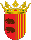
| coat of arms | Map of Spain | |

|
|
|
| Basic data | ||
| Autonomous Community : | Aragon | |
| Province : | Huesca | |
| Comarca : | Jacetania | |
| Coordinates | 42 ° 45 ′ N , 0 ° 50 ′ W | |
| Height : | 860 msnm | |
| Area : | 224.05 km² | |
| Residents : | 405 (Jan. 1, 2019) | |
| Population density : | 1.81 inhabitants / km² | |
| Postal code : | 22728 | |
| Municipality number ( INE ): | 22028 | |
| administration | ||
| Mayor : | Félix Ipas Barba (PSOE) | |
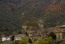
Ansó is a Spanish municipality in the province of Huesca in the far northwest of the autonomous community of Aragon in the comarca of Jacetania . It lies in the valley of the Río Veral, which flows from north to south, in the western Aragonese Pyrenees, and borders France and Navarre . The village of Zuriza also belongs to the municipality , while the small Fago to the west still forms an independent municipality. The now uninhabited village of Santa Lucía, located in the valley of the Río Veral below Ansó, already belongs to the municipality of Valle de Hecho .
geography
The elongated valley of Ansó opens to the south over the gorge Foz de Biniés to the valley of the Aragón . It is connected via a pass road with the Roncal valley in Navarra, which is adjacent to the west, and via another pass road with Hecho in the municipality of Valle de Hecho in the Aragón Subordán valley in the east. The highest mountain in the municipality is the Peña Forca (2,391 m).
history
The place was granted various royal privileges in 1272. In 1375 there was an arbitration ruling on grazing rights between the neighboring areas of the Béarn and the Roncal valley in Navarre , which led to a still existing delivery of three cows ( Tributo de las Tres Vacas ) to the Roncalese in exchange for pasture use.
economy
Historically, cattle breeding in the form of transhumance was predominant. Agriculture is affected by the altitude of the place. In Ansó, wood processing was also important in the past.
Labor emigration ("emigración golondrina") led women workers to manufacture espadrilles in Mauléon-Licharre in France.
Tourism has gained importance in recent times. In the far northwest of the municipality are the cross-country skiing slopes of Linza.
politics
| Distribution of seats in the municipal council | |||||||||
| Political party | 2003 | 2007 | 2011 | 2015 | |||||
| PSOE de Aragon | - | 4th | 4th | - | |||||
| PAR | - | 3 | 3 | - | |||||
| CHA | 7th | ||||||||
| Total | 7th | 7th | 7th | 7th | |||||
Source: Spanish Ministry of the Interior
Linguistic situation
In addition to Spanish (castellano), Ansotano, a variant of the Aragonese language , is spoken in the municipality .
Population development
| 1900 | 1910 | 1920 | 1930 | 1940 | 1950 | 1960 | 1970 | 1981 | 1991 | 1996 | 2001 | 2005 | 2009 |
|---|---|---|---|---|---|---|---|---|---|---|---|---|---|
| 1,192 | 1,136 | 950 | 1,078 | 957 | 992 | 831 | 682 | 486 | 426 | 509 | 533 | 525 | 497 |
Attractions
- The special architecture of the place with narrow, "arteas" passages between the houses.
- The parish church of San Pedro, a Gothic fortification from the 16th century with a baroque altar and an organ built in France from the 18th century and an ethnological museum.
- A medieval tower in which Queen Blanche II should have been imprisoned.
Community partnerships
Individual evidence
- ↑ Cifras oficiales de población resultantes de la revisión del Padrón municipal a 1 de enero . Population statistics from the Instituto Nacional de Estadística (population update).
- ↑ The Tribute of the Three Cows. Retrieved June 11, 2020 .
- ↑ Resultados provisionales - Ansó Ministerio del Interior - Subsecretaría Dirección General de Política Interior - 2011, accessed on July 11, 2018.
Web links
- www.valledeanso.com regularly updated data on the Ansó Valley.


