Beranuy
| Beranuy municipality | ||
|---|---|---|
| coat of arms | Map of Spain | |
 Help on coat of arms |
|
|
| Basic data | ||
| Autonomous Community : | Aragon | |
| Province : | Huesca | |
| Comarca : | Ribagorza | |
| Coordinates | 42 ° 22 ′ N , 0 ° 36 ′ E | |
| Height : | 995 msnm | |
| Area : | 63.75 km² | |
| Residents : | 82 (Jan 1, 2019) | |
| Population density : | 1.29 inhabitants / km² | |
| Postal code : | 22485 | |
| Municipality number ( INE ): | 22246 | |
| administration | ||
| Mayor : | Ramón Solana Abadías ( PSOE ) | |
Beranuy (until 2010 Veracruz ) is a municipality in the province of Huesca in the autonomous community of Aragon in Spain . It is located in the predominantly Catalan-speaking Franja de Aragón in the Isábena valley in the Comarca Ribagorza .
history
The municipality was formed in 1966 under the name Veracruz from the former municipalities of Beranuy and Calvera. It includes the following localities:
Population development
| 1991 | 1996 | 2001 | 2004 |
|---|---|---|---|
| 121 | 116 | 111 | 105 |
Attractions
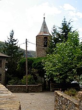
- Romanesque bell tower of the parish church of Asunción in Beranuy from the 12th century
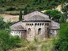
- Romanesque monastery of Santa María de Obarra with the monastery church of Santa María from the 11th century and the chapel ( Ermita ) San Pablo from the 12th century in Calvera
- Parish Church of San Andrés in Calvera from the 11th century
- Ermita Santa María in Calvera (towards Las Tozas) from the 12th century
- Ruins of the Ermita San Valero in Calvera from the 11th century
- Parish church of San Clemente in Raluy from the 11th century
literature
- Cayetano Enríquez de Salamanca : Rutas del Románico en la provincia de Huesca . Enríquez de Salamanca Editor, 2nd edition, Madrid 1993, ISBN 84-398-9582-8 .
- Total guide : Pirineo aragonés. 3rd edition, Grupo Anaya, Madrid 2005, ISBN 84-9776-047-6 , pp. 90-91.
Web links
Commons : Beranuy - collection of images, videos and audio files
Individual evidence
- ↑ Cifras oficiales de población resultantes de la revisión del Padrón municipal a 1 de enero . Population statistics from the Instituto Nacional de Estadística (population update).


