Lalueza
| Lalueza municipality | ||
|---|---|---|
| coat of arms | Map of Spain | |

|
|
|
| Basic data | ||
| Autonomous Community : | Aragon | |
| Province : | Huesca | |
| Comarca : | Monegros | |
| Coordinates | 41 ° 51 ′ N , 0 ° 15 ′ W | |
| Height : | 284 msnm | |
| Area : | 88.09 km² | |
| Residents : | 892 (Jan. 1, 2019) | |
| Population density : | 10.13 inhabitants / km² | |
| Postal code : | 22214 | |
| Municipality number ( INE ): | 22136 | |
| administration | ||
| Mayor : | Daniel Périz Vizcarra | |
| Website : | www.lalueza.es | |
Lalueza ( Aragonese A Lueza ) is a Spanish municipality located with its main part on the Río Flumen in the province of Huesca in the autonomous community of Aragon . It is in the Comarca of Monegros .
Parish parts
The municipal parts belong to Lalueza:
- Marcén with the former Gabarda castle on a witness mountain of the Torrollones de Gabarda
- San Lorenzo del Flumen, which was populated in the 1950s.
Population development
| 1991 | 1996 | 2001 | 2004 |
|---|---|---|---|
| 1389 | 1292 | 1183 | 1140 |
Attractions
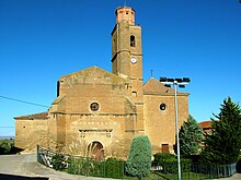
- The sober single-nave parish church from the 16th century with a Renaissance portal and sturdy tower.
Web links
Commons : Lalueza - collection of images, videos and audio files
- Lalueza in CAI-Aragón (Spanish text)
Individual evidence
- ↑ Cifras oficiales de población resultantes de la revisión del Padrón municipal a 1 de enero . Population statistics from the Instituto Nacional de Estadística (population update).


