Torla Ordesa
| Torla-Ordesa municipality | ||
|---|---|---|
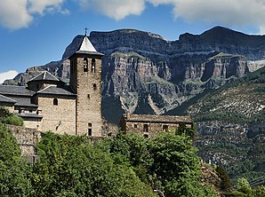
 Church of Torla and Monte Perdido massif
|
||
| coat of arms | Map of Spain | |
 Help on coat of arms |
|
|
| Basic data | ||
| Autonomous Community : | Aragon | |
| Province : | Huesca | |
| Comarca : | Sobrarbe | |
| Coordinates | 42 ° 38 ′ N , 0 ° 7 ′ W | |
| Height : | 1200 msnm | |
| Area : | 185.21 km² | |
| Residents : | 304 (Jan. 1, 2019) | |
| Population density : | 1.64 inhabitants / km² | |
| Postal code : | 22376 | |
| Municipality number ( INE ): | 22230 | |
| administration | ||
| Website : | Torla Ordesa | |
Torla-Ordesa , sometimes just Torla is a scattered from several hamlets (Pedanías) and individual farms (fincas) existing northern Spanish mountain village ( municipio ) with 304 inhabitants (at January 1, 2019) in the north of the province of Huesca in the autonomous community of Aragon .
Location and climate
The villages, hamlets and farmhouses of the municipality of Torla-Ordesa are located above the Río Ara at the foot of the 3355 m high Monte Perdido massif approx. 95 km (driving distance) northeast of the provincial capital Huesca at an average altitude of approx. 1200 m ; the neighboring town of Biescas is about 26 km to the west. The climate is temperate; Rain (approx. 885 mm / year) falls over the year.
Population development
| year | 1857 | 1900 | 1950 | 2000 | 2017 |
| Residents | 591 | 491 | 461 | 317 | 299 |
The increasing mechanization of agriculture in the 20th century resulted in a continuous loss of jobs and a significant decline in the number of inhabitants in most of Europe's mountain communities.
economy
In the past, the residents of the place lived directly or indirectly (as farmers, agricultural workers or craftsmen) from farming and livestock farming. Today tourism plays an important role in the economic life of the mountain community.
history
Neolithic , Celtic , Roman , Visigothic and Moorish traces have not yet been discovered in the region, so it can be assumed that the individual places of today's community only emerged in the Middle Ages as resting places or as stopovers for shepherds and their flocks. The first mention of the place name comes from the year 1076.
Attractions
- Torla
- The church of San Salvador has Romanesque origins, but the entire entrance area was in the 16th and 17th centuries. Century redesigned. The bell tower (campanar) dominates the exterior of the church. The interior of the church, which has also been renovated, has three aisles; the central nave vault has stitch caps , the side aisles have groin vaults .
- The Ermita de Santa Ana , built from rubble stones, is about 2 km east of the village; there is an inscription in the lintel.
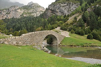
- The single-arched late medieval stone bridge Puente de Bujaruelo spans the Ara River ( 42 ° 41 ′ 42 ″ N , 0 ° 6 ′ 22 ″ W ).
- Another interesting, but two-arched late medieval stone bridge (Puente de la Glera) is located in the north of the municipality.
- Nearby are the ruins of the Romanesque chapel of San Nicolás de Bujaruelo or San Nicolás de Bari .
- Linas de Broto
- The Iglesia de San Miguel , dedicated to the Archangel Michael , was built in the 16th century. The striking south porch (portico) corresponds to that of Torla. The church is not vaulted, but has a wooden roof that is open to the interior .
Web links
Individual evidence
- ↑ Cifras oficiales de población resultantes de la revisión del Padrón municipal a 1 de enero . Population statistics from the Instituto Nacional de Estadística (population update).
- ↑ Torla-Ordesa - climate tables
- ^ Torla-Ordesa - population development
- ↑ Torla - Church of San Salvador
- ↑ Torla - Puente de Bujaruelo
- ↑ Torla - Puente de la Glera
- ↑ Torla - San Nicolás de Bujaruelo
- ↑ Linas de Broto - Church


