
Škofja Loka
|
Škofja Loka Bischoflack |
|||
|
|||
| Basic data | |||
|---|---|---|---|
| Country |
|
||
| Historic region | Upper Carniola / Gorenjska | ||
| Statistical region | Gorenjska (Upper Carniola) | ||
| Coordinates | 46 ° 10 ' N , 14 ° 18' E | ||
| surface | 145.0 km² | ||
| Residents | 22,647 (2008) | ||
| Population density | 156 inhabitants per km² | ||
| Post Code | 4220 | ||
| License Plate | KR | ||
| Structure and administration | |||
| Website | |||


Škofja Loka ( German Bischoflack , Bischofslack , 1941-1945 Laak an der Zaier ) is a town and a municipality in Slovenia . It lies on the Sora (German Zayer / Zeier) and the state railway line Ljubljana – Tarvisio and extends over an area of 145 km².
Residents
The entire municipality of Škofja Loka consists of 62 villages and hamlets.
| Population development | ||||
|---|---|---|---|---|
| year | 1850 | 2000 | 2004 | 2008 |
| Residents | 2,293 | 22,146 | 22,226 | 22,647 |
history
The place name Škofja Loka reminds of the German foundation of the place. The place is called Bischoflack in German . The " skoof " (= Old High German bishop) was the prince-bishop of Freising , then Bishop Abraham von Freising , to whom the area was given on June 30, 973 by Emperor Otto II . Loka (= Slovenian Au). The first documentary mention was made in the deed of donation.
Strategically located at the confluence of Selzacher (Selska) and Pöllander (Poljanska) Zaier (Sora), the Freising bishops planned to develop it into an administrative center of their rule: in 1248 the market rights were put on record, in 1262 the inhabitants were called "cives" (citizens) , 1310 Bischoflack received city rights. The city wall was mentioned in a document before 1286; with its five gates, it dates from the 14th century. The rule of the Bishops of Freising, which belonged to Bischoflack, finally encompassed an area of around 500 km² and around 200 villages.
In the "following centuries the bishops developed a considerable settlement movement" and called for the construction of the city and the reclamation of the thinly populated area, mainly German colonists, especially for the valley of the Selzach Zaier (Selščica). They came mainly from the areas of the then Duchy of Bavaria . Their dialect remained alive in some places into the 20th century and points to an origin in Tyrol ( Pustertal ), for example in the language island of Zarz (Sorica) and in the nearby Deutschruth (Nemški Rut), which belonged to the Aquileja monastery .
Regarding Zaierfeld (sl. Sorško poljee), the plain between Bischoflack and Krainburg (Kranj), and its residents, Valvasor wrote in 1689 in his description of the country of the Duchy of Carniola : " Among the same / one hears dreyerley languages; as the right Creinerische / right Teutsche / and / thirdly / the mixture of the Crainerisch and the Teutschen . "
Of the numerous setbacks caused by fires, plague, the effects of war and other catastrophes, the earthquake of 1515 turned out to be particularly serious because it almost completely devastated the city; Bishop Philipp had it rebuilt quickly, however, in a form that has been preserved to this day.
Freising existed until 1803, when the city fell to Austria.
In 1888, Bischoflack was part of the Krainburg district administration in the Austrian Duchy of Krain . It had a district court ( judicial district Bischoflack ), a Capuchin convent and an Ursuline convent , a Gothic parish church, an old castle, production of woolen blankets and parquet.
During the German occupation in World War II , the city bore the official German name Laak an der Zaier . Since it belonged to Yugoslavia and later Slovenia, the city has been called Škofja Loka today.
- coat of arms
The city coat of arms shows the Freising Mohr , because Bischoflack belonged to the Hochstift Freising . The Freising coat of arms can still be seen on numerous houses in the old town.
Attractions

The city center with the town square (mestni trg) and the lower square (spodnji trg) are particularly worth seeing; above is that
- City palace of the bishop. In 1202 this was called castrum firmissimum , i.e. a very strongly fortified castle. The castle had to be extensively repaired after the earthquake in 1511. Today it houses a museum. The St. Lucia , the palace chapel has an eight-sided floor plan and is equipped with baroque altars. The dome is decorated with stucco and painting. The chapel is currently (autumn 2018) being restored.

View into the castle museum

View into the dome of the palace chapel
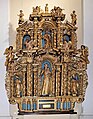
An altar of the palace chapel


- The Jakobskirche was built in 1471 on the foundations of an older church. The stone relief of the tympanum in the pointed arch of the Gothic west portal shows Jesus in the garden of Gethsemane . The three naves of the late Gothic hall building are the same height. The choir adjoins the central nave with a 3/8 end and three-bay star rib vault with stitch caps.

Tympanum of the west portal
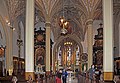
St.Jakob, interior view

View towards the organ gallery
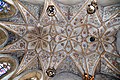
Choir vault

The main altar


.jpg)

- The nuns church (Maria Immaculata) dates back to 1358 and was rebuilt in 1669 in baroque style. Founded as the Poor Clare Monastery , the house passed into the possession of the Ursulines in 1782 , who set up a girls' school there.
- The Capuchin Bridge was built on the initiative of Bishop Leopold in the 14th century, who also became its first victim shortly after completion: he fell down into the creek while riding over the handrailless bridge and drowned. Since 1888 it has had an iron railing and a statue of the bridge saint Nepomuk .
- The Homan House was built after the 1511 earthquake. It is a city palace with three floors that combines late Gothic with Renaissance elements.
- The granary: it was used to store taxes in kind and was renovated after the earthquake of 1511.
- The hospital church was originally a poor house that was built in 1547. In 1698 the building fell victim to the flames and had to be rebuilt.
- The Žigon House, a building from the 16th century, is now used by the city administration.
- The old town hall on Mestni trg was built in the 16th century; a restoration of the facade in 1972 brought baroque frescoes to light.
Town twinning
Sister towns of Škofja Loka are
|
|
Furthermore, Škofja Loka is the Slovenian member of the European city community Douzelage , to which one city from each of the EU states belongs.
Born in Škofja Loka
- Othmar Murnik (1835–1901), Dept.
- Franz Stanonik (1841–1918), clergyman, theologian and university professor
- Andrej Karlin (1857–1933), Bishop of Trieste and Lavant
- Boris Strel (1959–2013), Yugoslav ski racer
- Špela Bračun (* 1977), ski racer
- Jan Oblak (* 1993), soccer goalkeeper
Districts of the entire municipality
- Binkelj , (German: Winkel bei Bischofslack)
- Bodovlje , (German: Fundöl, also Funthal)
- Bukov Vrh nad Visokim , (German: Buchenberg)
- Breznica pod Lubnikom , (German: Briesnitz bei der Lupnick, also Fresnitz)
- Brode , (German: Fuerthen, also Fürten)
- Bukovica , (German: Bukowitz near Bischofslack, also Sankt Clementis)
- Bukovščica , (German: beeches in the Upper Carniola)
- Crngrob , (German: Ehrengruben am Moosbach) with the famous church
- Dorfarje , (German: villages)
- Draga , (German: Draas)
- Forme , (German: Formach, also Farmach)
- Gabrk , (German: Gaberg)
- Gabrovo (Škofja Loka) Gabrovo , (German: Hinterburg, also Gabrau)
- Gabrška Gora , (German: Gabersberg, also Gallenhof, Gaberiachsberg)
- Godešič , (German: Neusaß in der Oberkrain, also Godeschitz)
- Gorenja vas - Reteče , (German: Baiersdorf, also Payrischdorf, Oberdorf an der Zeyer)
- Gosteče , (German: Gostendorf)
- Grenc , (German: border)
- Hosta , (German: Host, also Kast, Last, Kost)
- Knape , (German: Knappendorf in der Oberkrain)
- Kovski Vrh , (German: Kalech)
- Križna Gora , (German: Kreuzberg in der Oberkrain)
- Lenart nad Lušo , (German: Sankt Leonhard ob Luscha)
- Lipica , (German: Klein Saifnitz)
- Log nad Škofjo Loko , (German: Laag ob Bischofslack)
- Moškrin , (German: Maschgruben)
- Na Logu , (German: Naloch)
- Papirnica , (German: Kaltenbrunn near Bischofslack, also paper mill)
- Pevno , (German: Jägerdorf in der Oberkrain)
- Podpulfrca , (German: powder stone )
- Pozirno , (German: Pozirn, also Pozern)
- Praprotno , (German: flag field, also Varngried)
- Pungert , (German: Baumgarten)
- Puštal , (German: Burgstall near Bischofslack)
- Reteče , (German: Rattendorf)
- Rovte v Selški dolini , (German: Gereuth bei Bischofslack, also Schwarzenbach)
- Sopotnica , (German: Sabatberg in the Upper Carniola)
- Spodnja Luša , (German: Unterluscha, also Unterleuschach)
- Staniše , (German: Rettenberg in der Oberkrain)
- Stara Loka , (German: Altlack, also Altenlack)
- Stirpnik , (German: Stirpniach)
- Strmica , (German: Stermitz in der Oberkrain)
- Suha , (German: Zauchen am Kinsterbach, also search in the Oberkrain)
- Sveta Barbara , (German: Sankt Barbara in der Oberkrain)
- Svetega Petra Hrib , (German: Saint Peter in the Mountains)
- Sveti Andrej , (German: Sankt Andrä ob Wildenlack)
- Sveti Duh , (German: Holy Spirit near Bischofslack, also Oberarn)
- Sveti Florjan nad Škofjo Loko , (German: Sankt Florian bei Bischofslack)
- Sveti Ožbolt , (German: Sankt Oswald bei Bischofslack)
- Sveti Tomaž , (German: Sankt Thomas in der Oberkrain)
- Ševlje , (German: Erlach, also Scheule, Erla)
- Škofja Loka, (German: Bischofslack)
- Trata , (German: Trattern, also Tratten, Tratta)
- Trnje , (German: Terne, also Darnach, Dornach)
- Valterski Vrh , (German: Waldensberg, also Waltenskirch)
- Vešter , (German: German West, also Westert, Westradt, Obernwester, Westreden)
- Vincarje , (German: Weinzierl, also Weinzurl)
- Virlog , (German: Steinbrunnen, also Wirlach)
- Virmaše , (German: Ehrenau, also Erinrich, Emern in der Krain, Ermherrn, Erembrechen)
- Visoko pri Poljanah , (German: Vorderdorf in der Oberkrain, also Wisockheim)
- Zgornja Luša , (German: Oberluscha, also Oberleuschach)
- Zminec , (German: dragons, also Trachen, Sminz, Smintz)
literature
- Janez Bizjak, Ludwig Druml, Manfred Gietler, Paul Gleirscher, Josef Götz, Hans Haid: “Grenzlose Karawanken” (pp. 287–294), Edition: LEEB: ENSZEICHEN, Feistritz / Gail 2008, Verlag Gerhard Leeb; ISBN 978-3-9502379-0-0
Web links
Individual evidence
- ↑ Miha Kosi (Laibach): City foundation and city development. Problems and examples from the Slovenian area . In: Pro Civitate Austriae. Information on urban history research in Austria , New Series, Issue 14, Austrian Working Group for Urban History Research, Linz 2009, p. 7
- ↑ Clemens Dasler: Forest and Wildbann in the early German Empire: the royal privileges for the imperial church from the 9th to the 12th century . Böhlau Verlag, Cologne / Weimar 2001, ISBN 978-3-412-12800-5 , p. 86 ( google.at [accessed on June 22, 2018]).
- ^ Slovenia, a transit country: German culture off the main road . In: ZEIT ONLINE . ( zeit.de [accessed on June 22, 2018]).
- ↑ The Crowned Moor - SKOFJA LOKA. Retrieved June 22, 2018 .
- ^ Zarz / Sorica and Deutschrut / Rut - Sprachinselverein Wien. Retrieved June 22, 2018 .
- ^ Heinz-Dieter Pohl: Slovenian-German language contact. 1995, accessed June 22, 2018 .
- ^ City website , accessed May 15, 2017
- ↑ http://mapire.eu/de/map/firstsurvey/?layers=osm%2C1%2C73&bbox=1587577.6644707064%2C5803163.126100248%2C1599807.5889963347%2C5808332.180138033
- ↑ http://mapire.eu/de/map/firstsurvey/?layers=osm%2C1%2C73&bbox=1589055.701569075%2C5808277.9202325%2C1601285.6260947033%2C5813446.974270285
- ↑ http://mapire.eu/de/map/firstsurvey/?layers=osm%2C1%2C73&bbox=1592903.03189557%2C5803720.362129415%2C1605132.9564211983%2C5808889.416167201
- ↑ http://mapire.eu/de/map/firstsurvey/?layers=osm%2C1%2C73&bbox=1592903.03189557%2C5803720.362129415%2C1605132.9564211983%2C5808889.416167201
Bled | Bohinj | Cerklje na Gorenjskem | Gorenja vas-Poljane | Gorje | Jesenice | Jezersko | Kranj | Kranjska Gora | Naklo | Preddvor · Radovljica | Šenčur | Škofja Loka | Tržič | Železniki | Žiri | Žirovnica .