
Bueng Kan Province
| Bueng Kan | |
|---|---|
| บึงกาฬ | |

|
|
| statistics | |
| Capital: | Bueng Kan |
| Telephone code: | |
| Surface: |
4305 km² . |
| Residents: |
~ 390,000 (2011) . |
| Population density : | 90.6 E / km² . |
| ISO 3166-2 : | |
| Governor : | |
| map | |
  |
|

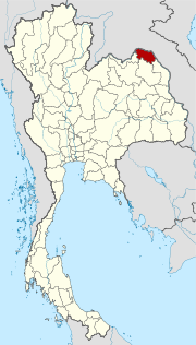
Bueng Kan ( Thai : บึงกาฬ , [ bɯ̄ŋ kāːn ]) is a province ( Changwat ) in the northeast region of Thailand , the so-called Isan .
The province was created in 2011 by splitting off from Nong Khai as the 76th and youngest province in Thailand.
The capital of Bueng Kan Province is also called Bueng Kan .
geography
The province is located on the northeastern edge of Thailand. It borders the following provinces (clockwise from the south): Nakhon Phanom , Sakon Nakhon and Nong Khai . To the north and east it borders on Laos with the Mekong as a natural border.
The Phu Wua wildlife sanctuary is located in the hills near the Mekong in the district of Bung Khla .
Important rivers
climate
The climate is tropical - monsoonal . The mean annual temperature is 26.2 ° C.
history
In 1994, Sumet Phromphanhao, a member of the House of Representatives from Nong Khai, proposed the establishment of a new province consisting of the eight eastern districts ( Amphoe ) of Nong Khai Province (Bueng Kan, Seka, So Phisai, Bung Khla, Bueng Khong Long, Pak Khat, Phon Charoen and Si Wilai). At that time, the Minister of the Interior refused to establish a new province on the grounds that it would put too great a burden on the state budget.
The proposal was put on hold for the next 20 years until the Interior Minister reactivated the project in 2010 and presented a “Law to Establish Changwat Bueng Kan” ( ร่าง พระราชบัญญัติ จัดตั้ง จังหวัด บึงกาฬ พ.ศ. ... ) to the Thai Council of Ministers . In a referendum, 98.83% of residents in Nong Khai Province supported the proposal. On August 3, 2010, the Council of Ministers decided to submit the proposal to the Thai parliament. The reasons given were as follows: the proposal had the minimum number of necessary ampheaas and inhabitants that are required by law for a province. In addition, the national border along the Mekong in Nong Khai province is very long, which makes security difficult.
On February 7, 2011, the law was passed by parliament. Prime Minister Abhisit Vejjajiva presented the Law Establishing Changwat Bueng Kan ( พระราชบัญญัติ ตั้ง จังหวัด บึงกาฬ พ.ศ. 2544 ) to King Bhumibol Adulyadej , who signed it on March 11, 2011. It was published in the government gazette on March 22, 2011, and it came into force the following day.
economy
The gross provincial product ( gross domestic product of the province) was 14.369 billion Baht (about 350 million euros) in 2011 . That corresponds to 33,027 baht per capita (about 810 euros), only about a fifth of the Thai average. This makes Bueng Kan one of the economically weakest provinces in the country. The share of the agricultural sector in economic output was 66.7%.
Administrative units
Provincial Administration
The province consists of eight amphoe ('districts' or 'counties'), which are further divided into 53 tambon ('subdistricts' or 'parishes') and 615 muban ('villages').
| No. | Amphoe | Thai | Overview of the Amphoe |
|---|---|---|---|
| 1. | Amphoe Mueang Bueng Kan | ( อำเภอ เมือง บึงกาฬ ) |

|
| 2. | Amphoe Phon Charoen | ( อำเภอ พรเจริญ ) | |
| 3. | Amphoe So Phisai | ( อำเภอ โซ่พิสัย ) | |
| 4th | Amphoe Seka | ( อำเภอ เซกา ) | |
| 5. | Pak Khat district | ( อำเภอ ปาก คาด ) | |
| 6th | Bueng Khong Long district | ( อำเภอ บึง โขง หลง ) | |
| 7th | Si Wilai district | ( อำเภอ ศรีวิไล ) | |
| 8th. | Amphoe Bung Khla | ( อำเภอ บุ่ง คล้า ) |
Local administration
A provincial administrative organization ( บริหาร ส่วน จังหวัด , อบ จ for short , Ongkan Borihan suan Changwat ; English Provincial Administrative Organization , PAO) exists for the entire area of the province .
There are also twelve thesaban tambon ( เทศบาล ตำบล - "small towns") and 41 tambon administrative organizations in the province .
Web links
- Provincial Government website (in Thai)
Individual evidence
- ↑ ค รม. ตั้ง 'บึงกาฬ' จังหวัด ที่ 77 แยก จาก หนองคาย [Cabinet resolves: Bueng Kan becomes 77th province, split from Nong Khai], Thai Rath, August 3, 2010.
- ↑ Question No. 176 R. . In: Ratchakitcha . 111, No. 24 A, March 22, 2011, p. 58.
- ↑ a b ชาว อ. บึงกาฬ ดีใจ มท. ชง เข้า ค รม. ตั้ง จังหวัด ใหม่ bangkokbiznews.com [People of A. Bueng Kan happy: Ministry of the Interior initiates cabinet resolution for new province.] Krungthep Thurakit, May 6, 2010.
- ^ Daily News , Aug. 4, 2010, p. 15.
- ↑ ค รม. มติ เห็น ชอบ ตั้ง 'บึงกาฬ' จังหวัด ที่ 77 [Cabinet adopts resolution for 77th province.] Krungthep Thurakit, August 3, 2010.
- ↑ ค รม. มี มติ ตั้ง จังหวัด บึงกาฬ เป็น จังหวัด ที่ 77. กระปุก ด อ ต คอม. สืบค้น 10-12-2553.
- ↑ วุฒิ ฯ จัด ให้ ผ่าน ฉลุ ย กฎหมาย จัดตั้ง 'จังหวัด บึงกาฬ' [Senate quickly approves law establishing Changwat Bueng Kan.] Thai Rath, Feb. 7, 2011.
-
↑ พระราชบัญญัติ ตั้ง จังหวัด บึงกาฬ พ.ศ. ๒๕๕๔ [Changwat Bueng Kan Establishment Act, 2554 BE (2011)] . In: Ratchakitchanubeksa [Government Gazette] . 128, No. 18 A, March 22, 2011, p. 1.
Act Establishing Changwat Bueng Kan, BE 2554. (2011, Wikisource English). - ↑ Gross Regional and Provincial Product, Chain Volume Measures 2011 (PDF; 1.5 MB), National Economic and Social Development Board. (PDF) Archived from the original on October 5, 2013 ; accessed on November 28, 2015 .
- ↑ Department of Provincial Administration : As of 2012 (in Thai)
North : Chiang Mai | Chiang Rai | Kamphaeng Phet | Lampang | Lamphun | Mae Hong Son | Nakhon Sawan | Nan | Phayao | Phetchabun | Phichit | Phitsanulok | Phrae | Sukhothai | Tak | Uthai Thani | Uttaradit
Northeast : Amnat Charoen | Bueng Kan | Buri Ram | Chaiyaphum | Kalasin | Khon Kaen | Loei | Maha Sarakham | Mukdahan | Nakhon Phanom | Nakhon Ratchasima | Nong Bua Lam Phu | Nong Khai | Roi Et | Sakon Nakhon | Si Sa Ket | Surin | Ubon Ratchathani | Udon Thani | Yasothon
Central : Ang Thong | Ayutthaya | Bangkok | Chachoengsao | Chai Nat | Chanthaburi | Chon Buri | Kanchanaburi | Lop Buri | Nakhon Nayok | Nakhon Pathom | Nonthaburi | Pathum Thani | Phetchaburi | Prachin Buri | Prachuap Khiri Khan | Ratchaburi | Rayong | Sa Kaeo | Samut Prakan | Samut Sakhon | Samut Songkhram | Saraburi | Sing Buri | Suphan Buri | Stepped
South : Chumphon | Krabi | Nakhon Si Thammarat | Narathiwat | Pattani | Phang-nga | Phatthalung | Phuket | Ranong | Satun | Songkhla | Surat Thani | Trang | Yala
Coordinates: 18 ° 22 ′ N , 103 ° 39 ′ E