
Mönchsdeggingen
| coat of arms | Germany map | |
|---|---|---|

|
Coordinates: 48 ° 47 ' N , 10 ° 35' E |
|
| Basic data | ||
| State : | Bavaria | |
| Administrative region : | Swabia | |
| County : | Danube Ries | |
| Management Community : | Ries | |
| Height : | 435 m above sea level NHN | |
| Area : | 32.06 km 2 | |
| Residents: | 1415 (Dec. 31, 2019) | |
| Population density : | 44 inhabitants per km 2 | |
| Postal code : | 86751 | |
| Area code : | 09088 | |
| License plate : | DON, Lower Austria | |
| Community key : | 09 7 79 184 | |
| LOCODE : | DE MGG | |
| Community structure: | 7 parts of the community | |
| Address of the municipal administration: |
Albstrasse 30 86751 Mönchsdeggingen |
|
| Website : | ||
| Mayoress : | Karin Bergdolt (Unity voters group) | |
| Location of the community of Mönchsdeggingen in the Donau-Ries district | ||
  |
||

Mönchsdeggingen is a municipality in the Swabian district of Donau-Ries and a member of the Ries administrative community based in Nördlingen .
geography
Mönchsdeggingen is located on the southern edge of the Nördlinger Ries . In the south it borders on the district of Dillingen . Geologically, the area belongs to the Riesalb , the easternmost, hilly foothills of the Swabian Alb.
The municipality has seven officially named municipality parts (the type of settlement is given in brackets ):
|
There are the districts of Merzingen, Mönchsdeggingen, Rohrbach, Schaffhausen, Untermagerbein and Ziswingen.
history
→ For the history of the monastery, see: Mönchsdeggingen Monastery
Until the church is planted
Deggingen was mentioned for the first time in 1007 in a document from King Heinrich II , in which the place - until then presumably imperial or Ottonian household - was given to the bishopric of Bamberg as a foundation equipment . The upper fiefdom of Bamberg remained undisputed until the end of the Old Kingdom , despite changing factual power relations .
The monastery had extensive property and numerous rights (including the patronage of the parish church of St. George) in the village. After the Counts of Oettingen succeeded the Lords of Hürnheim as monastery governors, the monastery and town increasingly slipped away from the highly canonical influence. Mönchsdeggingen was integrated into the county of Oettingen . When the house of Oettingen was divided, the bailiwick remained with the Catholic line of Oettingen-Wallerstein, the village belonged to Oettingen-Oettingen. The latter introduced the Reformation locally in the 16th century; the monastery remained unaffected. This had curious consequences, as the monastery as patron saint now had to appoint Protestant pastors.
In the Thirty Years War Mönchsdeggingen was badly destroyed , especially in the Battle of Nördlingen . To compensate for the population loss, Jews expelled from Pfalz-Neuburg were settled in 1684 . In the following two centuries these had a lasting influence on the economy, culture and the appearance of the village. In 1879 the Jewish community disbanded due to emigration to Übersee and Nördlingen.
In 1802 the monastery was dissolved. With the Rheinbund act 1806, the place, which had been in the Swabian Empire since 1500 , and the secularized monastery became part of the Kingdom of Bavaria . In 1818, with the municipal edict, today's political municipality was created.
20th and 21st centuries
In 1950, the Mariannhill Missionaries Congregation took over the old monastery buildings as a novitiate for their prospective priests.
On December 11, 1930, the name of the community was officially changed from Deggingen to Mönchsdeggingen.
In 2007 the place celebrated its 1000th anniversary.
Incorporations
On January 1, 1972, the previously independent municipalities of Merzingen, Schaffhausen and Ziswingen were incorporated. The lower leg was added on January 1, 1976. Rohrbach finally followed on May 1, 1978.
Population development
Between 1988 and 2018, the population decreased from 1,538 to 1,381 by 157 inhabitants or 10.2%.
- 1961: 1538 inhabitants
- 1970: 1581 inhabitants
- 1987: 1563 inhabitants
- 1991: 1563 inhabitants
- 1995: 1573 inhabitants
- 2000: 1542 inhabitants
- 2005: 1499 inhabitants
- 2010: 1366 inhabitants
- 2015: 1429 inhabitants
At the time of the 1987 census , more than three quarters (75.2%) of the population were Protestant and 22.2% Catholic . The proportions of both denominations decreased by the 2011 census . As before, the clear majority in 2011 was Protestant (66.5%), 20.2% were Catholic.
politics
Mayor and City Council
Karin Bergdolt (Voting Group Unity) has been mayor since May 1, 2020. Her predecessor was Karl Wiedenmann (CSU) from May 1, 2008 to April 30, 2020. In the local elections on March 15, 2020 , he no longer applied.
The municipal council has 12 members and is composed as follows for the 2020-2026 term of office:
- Unity 4 seats
- CSU / Free Citizens 3 seats
- Local district list lower leg 2 seats
- District list Rohrbach / Thurneck 2 seats
- District list Schafhausen 1 seat
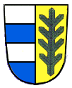
badges and flags
|
|
Blazon : “Over a red shield base, in it half a silver tray, split in blue and silver; in front a gold-armored silver goose, behind a red paw cross. "
The white and red municipal flag approved in 1990 is not used. |
| Reasons for the coat of arms: The cages recall the coat of arms of the Oettinger family, the goose stands for the St. Martin patronage of the monastery church, the paw cross for the St. George cross (St. George as patron of the parish church). |
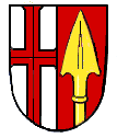
The incorporated, formerly independent communities of Merzingen, Rohrbach, Schaffhausen, Untermagerbein and Ziswingen had their own coats of arms:
- Coats of arms of the districts

Merzingen

Rohrbach
Schaffhausen

Lower leg
Ziswingen

.png)
.png)


Culture and sights
- Mönchsdeggingen Monastery
- Burgstall Thurneck
- former synagogue and mikveh
- Jewish Cemetery
- Prelate pond
- Evangelical Church of St. Nikolaus in Unterermagerbein
- Evangelical Church of St. George
- Mönchsdeggingen judicial linden tree in the Protestant cemetery of St. George's Church
- Kühsteinfelsen with geotope nature trail of the National Geopark Ries

monastery

Evangelical Church of St. Nikolaus in Unterermagerbein

Evangelical Church of St. George

Court linden tree


Architectural monuments
Economy and Infrastructure
Economy including agriculture and forestry
According to official statistics, there were eight employees at the place of work in 1998 in the field of agriculture and forestry, 52 in the manufacturing sector and nine in the field of trade and transport. In other areas of the economy 51 people were employed at the place of work subject to social security contributions. There were a total of 552 employees at the place of residence subject to social security contributions. There were two companies in the manufacturing sector and three in the construction sector. In addition, in 1999 there were 71 farms with an agricultural area of 1300 ha, of which 1022 ha were arable land.
education
The following institutions exist (as of 2011):
- Kindergartens: 50 kindergarten places with 28 children
- Elementary schools: one with 18 teachers and 251 students
literature
- Hans-Michael Körner , Alois Schmid (ed.), Martin Ott: Handbook of historical sites . Volume 7: Bavaria I. Part 1: Old Bavaria and Swabia (= Kröner's pocket edition . Volume 324). Kröner, Stuttgart 2006, ISBN 3-520-32401-6 .
Web links
- Mönchsdeggingen - former synagogue and ritual bath (mikveh) at Alemannia Judaica
- Entry on the coat of arms of Mönchsdeggingen in the database of the House of Bavarian History
Individual evidence
- ↑ "Data 2" sheet, Statistical Report A1200C 202041 Population of the municipalities, districts and administrative districts 1st quarter 2020 (population based on the 2011 census) ( help ).
- ^ Community Mönchsdeggingen in the local database of the Bavarian State Library Online . Bayerische Staatsbibliothek, accessed on September 1, 2019.
- ↑ a b Wilhelm Volkert (Ed.): Handbook of the Bavarian offices, communities and courts 1799–1980 . CH Beck, Munich 1983, ISBN 3-406-09669-7 , p. 541 .
- ↑ a b c Federal Statistical Office (ed.): Historical municipality directory for the Federal Republic of Germany. Name, border and key number changes in municipalities, counties and administrative districts from May 27, 1970 to December 31, 1982 . W. Kohlhammer, Stuttgart / Mainz 1983, ISBN 3-17-003263-1 , p. 793 .
- ↑ Official municipal statistics ( Memento of the original from March 4, 2016 in the Internet Archive ) Info: The archive link has been inserted automatically and has not yet been checked. Please check the original and archive link according to the instructions and then remove this notice. .
- ^ Entry on the coat of arms of Mönchsdeggingen in the database of the House of Bavarian History
- ↑ Entry on Mönchsdeggingen on the Kommunalflaggen.eu page
Merzingen | Mönchsdeggingen | Rohrbach | Schaffhausen | Thurneck | Lower leg | Ziswingen

Alerheim | Amerdingen | Asbach-Bäumenheim | Auhausen | Buchdorf | Daiting | Deiningen | Donauwörth | Ederheim | Ehingen am Ries | Forheim | Fremdingen | Fünfstetten | Genderkingen | Hainsfarth | Harburg (Swabia) | Hohenaltheim | Holzheim | Huisheim | Kaisheim | Maihingen | Marktoffingen | Marxheim | Megesheim | Mertingen | Mönchsdeggingen | Monheim | Möttingen | Munningen | Munster | Niederschönenfeld | Nordlingen | Oberndorf am Lech | Oettingen in Bavaria | Otting | Rain | Reimlingen | Rögling | Tagmersheim | Tapfheim | Wallerstein | Wechingen | Wemding | Wolferstadt
Unregulated areas: Dornstadt-Linkersbaindt | Ester wood