
Gannes
| Gannes | ||
|---|---|---|

|
|
|
| region | Hauts-de-France | |
| Department | Oise | |
| Arrondissement | Clermont | |
| Canton | Saint-Just-en-Chaussée | |
| Community association | Picard plateau | |
| Coordinates | 49 ° 34 ′ N , 2 ° 25 ′ E | |
| height | 104-144 m | |
| surface | 8.56 km 2 | |
| Residents | 340 (January 1, 2017) | |
| Population density | 40 inhabitants / km 2 | |
| Post Code | 60120 | |
| INSEE code | 60268 | |
| Website | http://www.mairie-gannes.fr/ | |

Gannes is a French municipality with 340 inhabitants (as of January 1 2017) in Oise in the region of Hauts-de-France (before 2016 Picardy ). It is located in the Arrondissement of Clermont and is part of the Communauté de communes du Plateau Picard and the canton of Saint-Just-en-Chaussée . The inhabitants are called Gannois .
geography
Gannes is about 35 kilometers northeast of Beauvais . Gannes is surrounded by the neighboring communities of La Hérelle in the north, Sains-Morainvillers in the east and northeast, Brunvillers-la-Motte in the southeast, Quinquempoix in the south, Ansauvillers in the west and Mory-Montcrux in the northwest.
Residents
| 1962 | 1968 | 1975 | 1982 | 1990 | 1999 | 2006 | 2013 | |
|---|---|---|---|---|---|---|---|---|
| 320 | 307 | 289 | 281 | 296 | 320 | 323 | 359 | |
| Source: Cassini and INSEE | ||||||||
Attractions
- Saint-Denis church from the 16th century (see also: List of Monuments historiques in Gannes )
- Notre-Dame-de-Bon-Secours chapel
- Gannes Castle
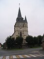
Saint-Denis church
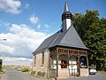
Notre-Dame-de-Bon-Secours chapel

Gannes Castle

.jpg)

Web links
Commons : Gannes - collection of images, videos and audio files