
Saint-Remy-en-l'Eau
| Saint-Remy-en-l'Eau | ||
|---|---|---|
|
||
| region | Hauts-de-France | |
| Department | Oise | |
| Arrondissement | Clermont | |
| Canton | Saint-Just-en-Chaussée | |
| Community association | Picard plateau | |
| Coordinates | 49 ° 28 ' N , 2 ° 26' E | |
| height | 75-171 m | |
| surface | 10.06 km 2 | |
| Residents | 416 (January 1, 2017) | |
| Population density | 41 inhabitants / km 2 | |
| Post Code | 60130 | |
| INSEE code | 60595 | |
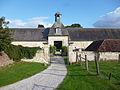
 Town hall (Mairie) of Saint-Remy-en-l'Eau |
||

St. Remy de-l'Eau is a French municipality with 416 inhabitants (as of January 1 2017) in Oise in the region of Hauts-de-France (before 2016 Picardy ). It is located in the Arrondissement of Clermont and is part of the Communauté de communes du Plateau Picard and the canton of Saint-Just-en-Chaussée . The inhabitants are called Saint-Remois .
geography
Saint-Remy-en-l'Eau is located about 35 kilometers east-northeast of Beauvais . Saint-Remy-en-l'Eau is surrounded by the neighboring communities of Valescourt in the north, Lieuvillers in the east, Cuignières in the southeast, Avrechy in the south and Fournival in the west.
Residents
| 1962 | 1968 | 1975 | 1982 | 1990 | 1999 | 2006 | 2013 | |
|---|---|---|---|---|---|---|---|---|
| 319 | 316 | 291 | 380 | 393 | 370 | 403 | 396 | |
| Source: Cassini and INSEE | ||||||||
Attractions
See also: List of Monuments historiques in Saint-Remy-en-l'Eau
- Saint-Rémy church from the 19th century
- 18th century castle, monument historique since 1987
- Castle (called Castle of Joan of Arc ) from the 15th century

Saint-Rémy church
lock

lock


.jpg)
Web links
Commons : Saint-Remy-en-l'Eau - Collection of images, videos and audio files