
Sains-Morainvillers
| Sains-Morainvillers | ||
|---|---|---|
|
||
| region | Hauts-de-France | |
| Department | Oise | |
| Arrondissement | Clermont | |
| Canton | Estrées-Saint-Denis | |
| Community association | Picard plateau | |
| Coordinates | 49 ° 34 ′ N , 2 ° 28 ′ E | |
| height | 102-143 m | |
| surface | 12.42 km 2 | |
| Residents | 273 (January 1, 2017) | |
| Population density | 22 inhabitants / km 2 | |
| Post Code | 60420 | |
| INSEE code | 60564 | |

Sains-Morainvillers is a French municipality with 273 inhabitants (as of January 1 2017) in the department of Oise in the region of Hauts-de-France . It belongs to the Arrondissement of Clermont and the canton of Estrées-Saint-Denis (until 2015: canton of Maignelay-Montigny ). Sains-Morainvillers is part of the Communauté de communes du Plateau Picard .
geography
Sains-Morainvillers is located about 30 kilometers northwest of Compiègne and about 81 kilometers north-northeast of Paris . Sains-Morainvillers is surrounded by the neighboring communities of Welles-Pérennes in the north, Crèvecœur-le-Petit in the east, Maignelay-Montigny in the south-east, Brunvilliers-la-Motte in the south, Gannes in the west and La Hérelle and Plainville in the north-west.
Population development
| year | 1962 | 1968 | 1975 | 1982 | 1990 | 1999 | 2006 | 2013 |
| Residents | 236 | 220 | 226 | 209 | 217 | 247 | 265 | 277 |
| Source: Cassini and INSEE | ||||||||
Attractions
- Saint-Brice church from the 16th century
- La Borde Castle
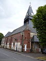
Saint-Brice church
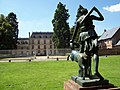
La Borde Castle

