Angicourt
| Angicourt | ||
|---|---|---|
|
|
||
| region | Hauts-de-France | |
| Department | Oise | |
| Arrondissement | Clermont | |
| Canton | Pont-Sainte-Maxence | |
| Community association | Pays d'Oise et d'Halatte | |
| Coordinates | 49 ° 19 ′ N , 2 ° 30 ′ E | |
| height | 38-120 m | |
| surface | 4.96 km 2 | |
| Residents | 1,396 (January 1, 2017) | |
| Population density | 281 inhabitants / km 2 | |
| Post Code | 60940 | |
| INSEE code | 60013 | |
| Website | http://www.angicourt.fr/ | |
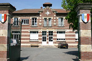
 Angicourt Town Hall |
||
Angicourt is a French commune with 1,396 inhabitants (as of January 1 2017) in the department of Oise in the region of Hauts-de-France . It belongs to the Arrondissement of Clermont and the canton of Pont-Sainte-Maxence (until 2015: canton of Liancourt ). Rieux is part of the Communauté de communes des Pays d'Oise et d'Halatte . The inhabitants are called Angicourtois .
geography
location
Angicourt is about 26 kilometers west-southwest of Compiègne and about 51 kilometers north-northeast of Paris .
Neighboring communities
| Verderonne | Rosoy | |
| Mogneville |

|
Cinqueux |
| Monchy-Saint-Éloi | Villers-Saint-Paul | Rieux |
Population development
| year | 1962 | 1968 | 1975 | 1982 | 1990 | 1999 | 2006 | 2013 |
| Residents | 571 | 969 | 1,363 | 1,495 | 1,538 | 1,525 | 1,653 | 1,529 |
| Source: Cassini and INSEE | ||||||||
Attractions
- Church of Saint-Vaast from the 12th century, Monument historique since 1862 (see also: List of Monuments historiques in Angicourt )
- Vogthaus
Web links
Commons : Angicourt - collection of images, videos and audio files

