
Maisoncelle Tuileries
| Maisoncelle Tuileries | ||
|---|---|---|
|
||
| region | Hauts-de-France | |
| Department | Oise | |
| Arrondissement | Clermont | |
| Canton | Saint-Just-en-Chaussée | |
| Community association | Oise Picarde | |
| Coordinates | 49 ° 35 ' N , 2 ° 13' E | |
| height | 110-188 m | |
| surface | 7.72 km 2 | |
| Residents | 301 (January 1, 2017) | |
| Population density | 39 inhabitants / km 2 | |
| Post Code | 60480 | |
| INSEE code | 60377 | |

Maison-Tuilerie is a French municipality with 301 inhabitants (at January 1, 2017) in Oise in the region of Hauts-de-France . The municipality is located in the Arrondissement of Clermont and is part of the Communauté de communes de l'Oise Picarde and the canton of Saint-Just-en-Chaussée .
geography
The municipality, touched by the A16 autoroute in the west, is four kilometers north of Froissy on the Picard plateau not far from a section of the former Chaussée Brunehaut , the course of which partially forms the western municipal boundary.
Residents
| 1962 | 1968 | 1975 | 1982 | 1990 | 1999 | 2006 | 2011 |
|---|---|---|---|---|---|---|---|
| 236 | 209 | 164 | 183 | 220 | 248 | 314 | 312 |
administration
Mayor ( maire ) has been Gérard Levoir since 2008.
Attractions
- Saint-Claude-Saint-Charles church, a brick structure from 1688, the nave from 1740
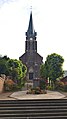
Saint-Claude-Saint-Charles church

Fallen memorial

School in Maisoncelle-Tuilerie
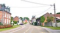
Place view


Web links
Commons : Maisoncelle-Tuilerie - Collection of images, videos and audio files