Reuil-sur-Brêche
| Reuil-sur-Brêche | ||
|---|---|---|
|
|
||
| region | Hauts-de-France | |
| Department | Oise | |
| Arrondissement | Clermont | |
| Canton | Saint-Just-en-Chaussée | |
| Community association | Oise Picarde | |
| Coordinates | 49 ° 31 ' N , 2 ° 13' E | |
| height | 100-161 m | |
| surface | 12.58 km 2 | |
| Residents | 329 (January 1, 2017) | |
| Population density | 26 inhabitants / km 2 | |
| Post Code | 60480 | |
| INSEE code | 60535 | |
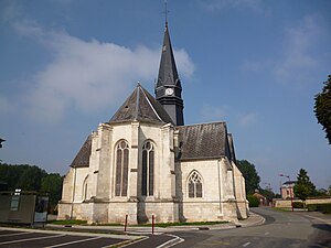
 The Saint-Martin church |
||
Reuil-sur-Brêche is a French municipality with 329 inhabitants (at January 1, 2017) in Oise in the region of Hauts-de-France . The municipality is located in the Arrondissement of Clermont and is part of the Communauté de communes de l'Oise Picarde and the canton of Saint-Just-en-Chaussée (until 2015: Canton Froissy ).
geography
The municipality in which the river Brèche or Brêche rises is located around 15.5 kilometers north-northeast of Beauvais, east of the A16 autoroute . The Mauregard homestead in the east belongs to the community.
Residents
| 1962 | 1968 | 1975 | 1982 | 1990 | 1999 | 2006 | 2011 |
|---|---|---|---|---|---|---|---|
| 205 | 194 | 207 | 196 | 221 | 206 | 259 | 307 |
administration
Mayor ( maire ) has been Carlo Zanuso since 2014.
Attractions
See also: List of Monuments historiques in Reuil-sur-Brêche
- Saint-Martin church with a choir from 1551 and several glazings from the 16th to 19th centuries
- Grangie Mauregard of the former Cistercian monastery Froidmont , registered as a Monument historique in 1988
Individual evidence
- ↑ http://clochers.org/Fichiers_HTML/Accueil/Accueil_clochers/60/accueil_60535.htm
- ↑ Abbaye de Froidmont in the Base Mérimée of the French Ministry of Culture (French)
Web links
Commons : Reuil-sur-Brêche - Collection of images, videos and audio files

