
Bonvillers
| Bonvillers | ||
|---|---|---|

|
|
|
| region | Hauts-de-France | |
| Department | Oise | |
| Arrondissement | Clermont | |
| Canton | Saint-Just-en-Chaussée | |
| Community association | Oise Picarde | |
| Coordinates | 49 ° 35 ' N , 2 ° 21' E | |
| height | 67-113 m | |
| surface | 5.86 km 2 | |
| Residents | 204 (January 1, 2017) | |
| Population density | 35 inhabitants / km 2 | |
| Post Code | 60120 | |
| INSEE code | 60085 | |
| Website | http://www.bonvillers.fr/ | |
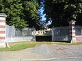
 Town Hall (Mairie) and Bonvillers School |
||

Bonvillers is a French municipality with 204 inhabitants (at January 1, 2017) in Oise in the region of Hauts-de-France (before 2016 Picardy ). It is located in the Arrondissement of Clermont and is part of the Communauté de communes de l'Oise Picarde and the canton of Saint-Just-en-Chaussée ( Breteuil until 2015 ). The inhabitants are called Bonvillois .
geography
Bonvillers is located about 52 kilometers south-southeast of Amiens . Bonvillers is surrounded by the neighboring communities of Beauvoir in the north and northwest, Chepoix in the north and east, Ansauvillers in the east and southeast, Campremy in the south and southwest and Saint-André-Farivillers in the west.
Residents
| 1962 | 1968 | 1975 | 1982 | 1990 | 1999 | 2006 | 2013 | |
|---|---|---|---|---|---|---|---|---|
| 146 | 143 | 145 | 165 | 177 | 191 | 201 | 228 | |
| Source: Cassini and INSEE | ||||||||
Attractions
- Saint Martin Church
- lock

Saint Martin Church
lock


Web links
Commons : Bonvillers - collection of images, videos and audio files
- Monuments historiques (objects) in Bonvillers in the base Palissy of the French Ministry of Culture