Campremy
| Campremy | ||
|---|---|---|
|
|
||
| region | Hauts-de-France | |
| Department | Oise | |
| Arrondissement | Clermont | |
| Canton | Saint-Just-en-Chaussée | |
| Community association | Oise Picarde | |
| Coordinates | 49 ° 34 ′ N , 2 ° 19 ′ E | |
| height | 118-175 m | |
| surface | 10.21 km 2 | |
| Residents | 490 (January 1, 2017) | |
| Population density | 48 inhabitants / km 2 | |
| Post Code | 60480 | |
| INSEE code | 60123 | |
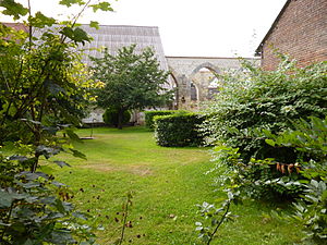
 The tithe barn of Grandmesnil |
||
Campremy is a French municipality with 490 inhabitants (at January 1, 2017) in Oise in the region of Hauts-de-France . The municipality is located in the Arrondissement of Clermont and is part of the Communauté de communes de l'Oise Picarde and the canton of Saint-Just-en-Chaussée .
geography
The municipality is located around eight kilometers east of Froissy and nine kilometers south of Breteuil (Oise) . The district of Grand Mesnil belongs to the municipality. There is a wind farm in the east of the municipality.
history
In the 14th century Campremy was under the rule of Jean de Bacquencourt.
Residents
| 1962 | 1968 | 1975 | 1982 | 1990 | 1999 | 2006 | 2011 |
|---|---|---|---|---|---|---|---|
| 305 | 341 | 285 | 267 | 319 | 332 | 372 | 418 |
administration
Mayor ( maire ) has been Benoît Grégoire since 1995.
Attractions
See also: List of Monuments historiques in Campremy
- Grange de Grandmesnil, a Cistercian building of Froidmont Abbey from 1210, partially registered as a Monument historique in 1992
- Saint Jean Baptiste Church
Individual evidence
- ↑ Entry no. PA00114759 in the Base Mérimée of the French Ministry of Culture (French)
Web links
Commons : Campremy - collection of images, videos and audio files
