
Hague in Upper Bavaria
| coat of arms | Germany map | |
|---|---|---|
.svg)
|
Coordinates: 48 ° 10 ' N , 12 ° 11' E |
|
| Basic data | ||
| State : | Bavaria | |
| Administrative region : | Upper Bavaria | |
| County : | Mühldorf am Inn | |
| Height : | 540 m above sea level NHN | |
| Area : | 20.37 km 2 | |
| Residents: | 6602 (Dec. 31, 2019) | |
| Population density : | 324 inhabitants per km 2 | |
| Postal code : | 83527 | |
| Area code : | 08072 | |
| License plate : | MÜ, VIB , WS | |
| Community key : | 09 1 83 119 | |
| LOCODE : | DE HA9 | |
| Market structure: | 31 districts | |
Market administration address : |
Marktplatz 7 83527 Haag i.OB |
|
| Website : | ||
| Mayoress : | Elisabeth Schätz ( SPD ) | |
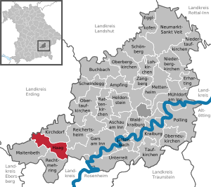
| Location of the Haag i.OB market in the Mühldorf am Inn district | ||
  |
||

Haag in Oberbayern (officially: Haag i.OB ) is a market in the Upper Bavarian district of Mühldorf am Inn and is located at the intersection of the B 12 and B 15 . As the center of the Hague Country, it has an eventful past.
geography
Geographical location
The place is located in the region of southeast Upper Bavaria in the foothills of the Alps and thanks to its elevated position offers a comprehensive view of the chain of the Bavarian Alps , which define the horizon in the south. There are also relics from the last Ice Age, namely the dead ice kettle southeast of the community. Haag is conveniently located around 50 km east of the state capital Munich , 15 km south of Dorfen , 21 km west of Waldkraiburg , 14 km north of Wasserburg and 32 km from the district town of Mühldorf . On the B 15 it is 48 km to Landshut and 38 km to Rosenheim . The nearest train station is 8 km away in the neighboring town of Soyen on the Rosenheim – Mühldorf railway line , which is served by the Südostbayernbahn .
Neighboring communities
Community structure
There are 31 districts:
|
history


Until the church is planted
Haag was first mentioned around the year 980 as the seat of the free gentlemen “de Haga”. In 1245 Haag was transferred from Emperor Friedrich II to Sigfrid von Fraunberg. At the same time the high jurisdiction of the county of Haag was confirmed as an imperial fief. In 1324 the county received the market rights for its market "zu dem Hage" from Emperor Ludwig IV . In the 15th and 16th centuries, the Fraunbergers were elevated to hereditary imperial counts from imperial feudal holders via imperial barons. In 1566 after the death of Count Ladislaus von Fraunberg-Haag, the Bavarian duke was enfeoffed with Haag in 1567. Until 1804, Haag was a "free imperial county not incorporated into the Bavarian Courlands", although it was dominated by Bavaria.
In 1808 Haag became an independent parish, and in 1813 the first mayoral elections were made. In the course of the administrative reforms in Bavaria , today's municipality was created with the municipal edict of 1818 .
19th and 20th centuries
In 1831 a great fire raged in Hague. In 1900 the Thann-Matzbach-Haag railway line , which was closed again in 1974, was opened.
The Hague District Court was dissolved on January 1, 1970.
Incorporations
On April 1, 1971, Haag received parts of the area of the dissolved municipality of Rosenberg. On July 1, 1971, parts of Allmannsau were added. The neighboring village of Kirchdorf bei Haag , three kilometers away , used to be part of the market.
Population development
Between 1988 and 2018 the market grew from 4,740 to 6,520 by 1,780 inhabitants or by 37.6%.
politics
Mayoress
The first female mayor is Elisabeth Schätz (SPD).
Municipal council
The municipal council has 20 members and is composed as follows after the 2014 municipal elections :
| CSU | 7 seats |
| Non-party voter community (PWG) | 5 seats |
| SPD | 3 seats |
| Free voters Hague | 3 seats |
| WFH | 2 seats |
coat of arms
|
|
Blazon : "In red a jumping silver horse with bridle."
The municipal coat of arms is based on the coat of arms of the local aristocratic family, the county of Haag, and shows the " Coo of Haag", the so-called Hague white horse on a red background. It has been run by the municipality of Haag since the 18th century. |
economy
Haag has an economic structure based on small businesses and crafts. The Jäger dairy factory with around 400 employees, which specializes in cheese production with a focus on Italian cheeses, the Unertl wheat beer brewery and the metal construction company Schletter are known nationwide .
Educational institutions
Haag has a primary / secondary school and a secondary school . In the 2004/2005 school year, it was the first secondary school in Bavaria to attempt to make school clothing mandatory. This obligation no longer exists since 2014. There could be no actual compulsion to wear school clothes purely under school law, as this is not provided for in the Bavarian school regulations.
Attractions

- Haag castle complex with a large castle tower with four bay windows
- Lion fountain, laid out in 1557
- Brewery with Gothic stepped gable, around 1560
- Zehentstadel, around 1538
- The Catholic parish church of the Assumption of Mary , formerly a hospital church from 1558
- Hospital building from 1588, later the old town hall
- Later brewery buildings from the Baroque period, 1730–1732
- Rambold House on Mühldorfer Strasse
- Rössler House in Kirchdorfer Strasse
- Nazarene style cemetery church , 1830
Soil monuments
See: List of soil monuments in Haag in Upper Bavaria
Sons and daughters of Haag
- August von Schätz (1856–1911), ministerial official in Bavaria
- Karl Gebhardt (1897–1948), surgeon, executed Nazi criminal against humanity
- Hermann Zenz (1926–2009), politician (CSU)
- Peter Syr (* 1945), exhibition maker, cultural manager and graphic designer
- Jochen Weigl (* 1971), soccer player and trainer
- Anne Breitreiner (* 1984), national basketball player
literature
- Franz Dionys Reithofer : Chronological history of the market | Haag in Bavaria, with one more appendix; from original manuscripts . 1818 ( e-copy ).
Web links
- Market Haag i. IF
- Museum of the history of the Hague
- Haag in Oberbayern: Official statistics of the LfStat
Individual evidence
- ↑ "Data 2" sheet, Statistical Report A1200C 202041 Population of the municipalities, districts and administrative districts 1st quarter 2020 (population based on the 2011 census) ( help ).
- ↑ The Toteiskesselweg in the Hague Land . Retrieved February 12, 2019.
- ↑ Entry in the location database
- ^ Wilhelm Volkert (ed.): Handbook of Bavarian offices, communities and courts 1799–1980 . CH Beck, Munich 1983, ISBN 3-406-09669-7 , p. 589 .
- ↑ Municipal Council. Haag municipality in Upper Bavaria, accessed on August 9, 2020 .
- ↑ Entry on the coat of arms of Haag in Upper Bavaria in the database of the House of Bavarian History
- ↑ Alexander Belyamna: School clothes no longer have to be worn. In: innsalzach24.de. March 21, 2014, accessed February 12, 2019 .

Ampfing |
Aschau am Inn |
Buchbach |
Egglkofen |
Erharting |
Gars am Inn |
Hague in Upper Bavaria |
Hero's Stone |
Jettenbach |
Kirchdorf |
Kraiburg am Inn |
Lohkirchen |
Maitenbeth |
Mettenheim |
Mühldorf am Inn |
Neumarkt-Sankt Veit |
Niederbergkirchen |
Niedertaufkirchen |
Oberbergkirchen |
Oberneukirchen |
Obertaufkirchen |
Polling |
Rat churches |
Right more |
Reichertsheim |
Schoenberg |
Schwindegg |
Taufkirchen |
Unterreit |
Waldkraiburg |
Zangberg
Unregulated areas in the district of Mühldorf a.Inn
Mühldorfer Hart