Aspach (Upper Austria)
|
market community Aspach
|
||
|---|---|---|
| coat of arms | Austria map | |
|
|
||
| Basic data | ||
| Country: | Austria | |
| State : | Upper Austria | |
| Political District : | Braunau am Inn | |
| License plate : | BR | |
| Surface: | 31.46 km² | |
| Coordinates : | 48 ° 11 ' N , 13 ° 18' E | |
| Height : | 443 m above sea level A. | |
| Residents : | 2,613 (January 1, 2020) | |
| Population density : | 83 inhabitants per km² | |
| Postcodes : | 5252 Aspach 4933 Wildenau 5251 Höhnhart 4931 Mettmach 4932 Kirchheim im Innkreis |
|
| Area code : | 07755 | |
| Community code : | 4 04 02 | |
| Address of the municipal administration: |
Marktplatz 9 5252 Aspach |
|
| Website: | ||
| politics | ||
| Mayor : | Georg Gattringer ( ÖVP ) | |
|
Municipal Council : (2015) (25 members) |
||
| Location of Aspach in the Braunau am Inn district | ||
| Source: Municipal data from Statistics Austria | ||
Aspach is a market town in Upper Austria in the Braunau am Inn district in the Innviertel with 2613 inhabitants (as of January 1, 2020). The responsible judicial district is the judicial district Braunau am Inn .
geography
Aspach is 443 m above sea level in the Innviertel in the Kobernaußerwald . The extension is 9.8 km from north to south and 7.1 km from west to east. The total area is 31.5 km². 17.5% of the area is forested, 73.3% of the area is used for agriculture.
The Mettmacher Ache flows through Wildenau and flows into the Waldzeller Ache ( Ach ). In the far west, the Sankt Veiter Bach flows for about 500 meters through the municipality.
climate
|
Average monthly temperatures and precipitation for Aspach
|
|||||||||||||||||||||||||||||||||||||||||||||||||||||||||||||||||||||||||||||||||||||||||||||||||||||||||||||||||||||||||||||||||||||||||||||||||||||||||||||||||||||||||
Community structure
The municipal area comprises the following 38 localities (population in brackets as of January 1, 2020):
- Aichet (15)
- Aspach (871)
- Au (90)
- Baumgarten (32)
- Bookkeeping (19)
- Döging (18)
- Dötting (19)
- Ecking (8)
- Eigelsberg (34)
- Eisecking (16)
- Englham (25)
- Backwood (128)
- Hobling (18)
- Kappeln (32)
- Casing (40)
- Kasting (42)
- Katzlberg (8)
- Small cut (53)
- Leithen (29)
- Leithen am Walde (30)
- Maierhof (24)
- Migelsbach (74)
- Mitterberg (11)
- Needleling (9)
- Niederham (6)
- Offenschwandt (23)
- Parz (1)
- Pimberg (34)
- Reed (19)
- Roith (36)
- Rottersham (14)
- Steinberg (42)
- Teinsberg (11)
- Thal (14)
- Water Dobl (38)
- Weissau (11)
- Wieselberg (26)
- Wildenau (693)
The community consists of the cadastral communities Aspach, Obermigelsbach and Wildenau.
Neighboring communities
| St. Veit im Innkreis | Polling in the Innkreis |
Kirchheim im Innkreis ( District Ried im Innkreis ) |
| Rossbach |

|
Mettmach ( District Ried im Innkreis ) |
| Höhnhart | Sankt Johann am Walde |
Population development

From 1981 to 2001 the balance of migration was negative, but the population increased due to the high birth rate. Since 2001, both the birth balance and the migration balance have been positive.
coat of arms
Blazon : Split and divided by a silver wavy bar. Above right in blue on a green hill a silver, black open and red roofed church with a high central nave, two side aisles and a tower built in front on the left with five heels and a high double onion helmet; Upper left split three times by silver and red. Below right in gold three green, adjacent, rootless, conifers that are getting smaller towards the outside; lower left in blue two golden, diagonally crossed keys with beards turned outwards and upwards, the letter P in the handle of the upper one on the left, the Roman numeral II in the handle of the other.
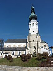
The church on the hill was adopted as the landmark of the market because of its basilica design, which is unique in the entire Innviertel. The Upper Austrian state colors indicate that Aspach was the first municipality to be elevated to a market municipality by the state law in 1928. The forest trees mark the location of the municipality in the Kobernaußerwald, the number of three symbolizes the tax municipality of Aspach, Wildenau and Obermigelsbach. The keys with the initials P and II refer to the former beneficiary, pastor of Aspach and later Pope Pius II, Aeneas Sylvius Piccolomini.
history

The former Burgstall Grindelsberg ramparts go back to prehistoric times .
Since the founding of the Duchy of Bavaria , the place was Bavarian until 1779 and came to Austria after the Treaty of Teschen with the Innviertel (then called Innbaiern). In the 18th century, the Counts of Wartenberg, who were descended from the Wittelsbach family , owned an extensive Hofmark in Aspach .
During the Napoleonic Wars briefly Bavarian again , since 1816 it has finally belonged to Austria on the Enns and from 1918 to Upper Austria. Aspach was the first municipality to be raised to a market municipality by state law in 1928. After Austria was annexed to the German Reich on March 13, 1938, the place belonged to the "Gau Oberdonau". After 1945 the restoration of Upper Austria took place.
On July 4, 1929, a fateful storm raged over Aspach in the evening hours, which caused the church tower to fall on the sacristan's house. The building was partly completely destroyed, nobody was injured.
politics
- mayor
- Georg Gattringer (ÖVP)
Culture and sights
The cultural offer has been greatly expanded in recent years, so in addition to the European concert summer , the performances of the Aspacher theater group and numerous folk music and traditional events are to be mentioned.
- 1. Innviertel Trachtenmusikkapelle Solinger
- Aspacher Tridoppler
- Aspacher three-height song
economy
Aspach is a local supplier, agricultural products play a major role. The place has a community doctor and the four volunteer fire brigades Aspach, Migelsbach, Wasserdobl and Wildenau, who provide fire protection and general help.
In 2005 the townscape fair took place in Aspach , where 80 municipalities from Upper Austria and 50 other exhibitors presented projects in the areas of townscape , culture , leisure , tourism and tradition . The event for village and urban development was dominated by Austria's ten-year membership in the European Union .
- Established businesses
- BOM Business Organization Management GmbH
- Edinger dealership
- Revital Aspach
- Villa Vitalis
- Former Kneipp spa house of the Sisters of Mary from Carmel , which was closed in November 2017
- Hotel Gasthof Danzer
- Seifried dairy
- creARTiv advertising graphics Gufler
- Irran Nursery
- Aspach brewery
- Mittermayr fashion house
- MC-U GmbH
- Zens fashion house
- Warehouse
traffic
Aspach is located directly on the Oberinnviertel state road L507.
education
In Aspach there is an elementary school and a new middle school, as well as a kindergarten.
Personalities
- Pope Pius II (1405–1464), pastor of Aspach 1444–1447, Pope from 1458 to 1464
- Georg Wagnleithner (1861–1930), priest, author and musician
- Engelbert Katzlberger (1868–1959), mayor and member of the state parliament
- Engelbert Daringer (1882–1966), church painter and restorer
- Anton Pointecker (1938–2008), actor
- Manfred Daringer (1942–2009), sculptor
Web links
- Website of the municipality of Aspach
- 40402 - Aspach (Upper Austria). Community data, Statistics Austria .
- More information about the municipality of Aspach (Upper Austria) on the geographic information system of the federal state of Upper Austria .
Individual evidence
- ^ Province of Upper Austria - Geographical data for the municipality of Aspach .
- ↑ Statistics Austria: Population on January 1st, 2020 by locality (area status on January 1st, 2020) , ( CSV )
- ↑ Statistics Austria, A look at the community Aspach, population development. Retrieved April 7, 2019 .
- ^ State of Upper Austria, history and geography, coat of arms. Retrieved April 7, 2019 .
- ↑ Aspach municipality, politics, mayor. Retrieved April 7, 2019 .
- ↑ Ortbildmesse in Aspach 2005 ( Memento of the original from April 15, 2016 in the Internet Archive ) Info: The archive link was inserted automatically and has not yet been checked. Please check the original and archive link according to the instructions and then remove this notice.
- ↑ Ortsbildmesse2152005 OÖ. Landeskorrespondenz Aspach is this year the venue for the local picture fair
- ↑ Aspach community, school and education. Retrieved April 7, 2019 .
- ^ Upper Austria regional library - Aspach community


