Lamoura
| Lamoura | ||
|---|---|---|
|
|
||
| region | Bourgogne-Franche-Comté | |
| Department | law | |
| Arrondissement | Saint-Claude | |
| Canton | Saint-Lupicine | |
| Community association | Station des Rousses-Haut Jura | |
| Coordinates | 46 ° 24 ' N , 5 ° 58' E | |
| height | 1,064-1,495 m | |
| surface | 22.28 km 2 | |
| Residents | 642 (January 1, 2017) | |
| Population density | 29 inhabitants / km 2 | |
| Post Code | 39310 | |
| INSEE code | 39275 | |
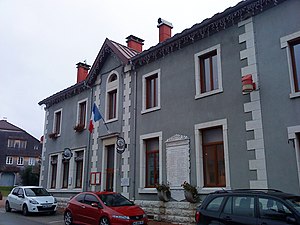
 Mairie Lamoura |
||
Lamoura is a commune in the French department of Jura in the region Bourgogne Franche-Comté .
geography
Lamoura is located at 1154 m and is one of the highest enclosed localities in the French Jura , about eight kilometers east of the city of Saint-Claude (as the crow flies). The former street row village extends in the High Jura, in a hollow on the northeastern edge of the Hautes-Combes, west of the Crêt Pela .
The area of the 22.28 km² large municipality covers a section of the French Jura. The area lies exclusively on the plateau of the Hautes-Combes (on average at 1150 m ). The landscape is wavy and shows terrain structures such as ridges and hollows, which are oriented in a south-west-north-east direction according to the direction of the fold of the Jura in this area. Most of the basin layers have no above-ground runoff, as the rainwater seeps away immediately into the porous calcareous subsoil. The only surface running water is the Bief Froid . It rises at the foot of the Crêt Pela and flows through a wide syncline valley , the Combe du Lac , to the southwest. To the east of the village is the small Lac de Lamoura.
While the plateau in the southwestern part of the municipality shows a loose structure of pastureland and forest, there are extensive forest areas to the northeast. The ridges rise gradually to the northeast. The syncline of the Bief Froid is flanked on its north side by the Bois de Tresberruy ( 1244 m ) and the Bois de Ban ( 1381 m ), on the south side by the anticline of the Crêt Pela, on which the highest point of Lamoura is reached at 1495 m . In various places there are typical karst phenomena such as sinkholes and cart fields . The municipal area extends in a long strip to the northeast almost to the state border with Switzerland and includes a large part of the Forêt du Massacre . The municipality is part of the Upper Jura Regional Nature Park (French: Parc naturel régional du Haut-Jura ).
In addition to the actual village, Lamoura also includes various hamlets and numerous individual farms, including:
- Tréchaumont ( 1120 m ) in a valley southwest of the village
- Chaux-Berthod ( 1160 m ) on the western edge of the Bois de Tresberruy
Neighboring municipalities of Lamoura are
- Longchaumois and Prémanon in the north,
- Lajoux in the east and south,
- Septmoncel les Molunes with Septmoncel in the west,
- Saint-Claude also to the west.
history
The area around Lamoura was cleared and reclaimed by the monks of the Saint-Claude monastery in the 11th century. For a long time the settlement was only inhabited in the summer months. The Forêt du Massacre east of the village got its name after the troops of the Duke of Savoy attacked around 600 Italian mercenaries in 1535, who were sent by the French King Francis I to reinforce the city of Geneva, which was besieged by the Savoyers .
With the separation from Septmoncel, Lamoura was raised to an independent municipality in 1839.
Attractions
The village church of Lamoura was built in the 19th century. In the Musée du Lapidaire the art of gemstone cutting is shown.
population
| Population development | |
|---|---|
| year | Residents |
| 1962 | 240 |
| 1968 | 215 |
| 1975 | 333 |
| 1982 | 379 |
| 1990 | 388 |
| 1999 | 436 |
| 2005 | 524 |
With 642 inhabitants (as of January 1, 2017) Lamoura is one of the small communities in the Jura department. After the population had decreased markedly in the first half of the 20th century (909 people were still counted in 1886), a significant increase in population has been recorded since the beginning of the 1970s.
Economy and Infrastructure
Until well into the 20th century, Lamoura was primarily a village characterized by agriculture , in particular cattle and dairy farming, and forestry. In addition, there are now some local small businesses. Many workers are also commuters who work in the larger towns in the area.
As a resort in a popular excursion area in the High Jura, Lamoura today also benefits from tourism, especially from winter tourism, when cross-country skiing can be practiced on the Hautes-Combes plateau. The slopes west of the Crêt Pela are accessible by ski lifts for alpine skiing. A modern holiday village was built in the Combe du Lac.
The village is located off the main thoroughfares, but is easy to reach from Septmoncel and Lajoux on the D936 (Saint-Claude-Col de la Faucille). Further road connections exist with Longchaumois and Les Rousses .
