
Partenen
|
Partenen ( Rotte ) locality |
|||
|---|---|---|---|
|
|||
| Basic data | |||
| Pole. District , state | Bludenz (BL), Vorarlberg | ||
| Judicial district | Bludenz | ||
| Pole. local community | Gaschurn ( KG Gaschurn) | ||
| Coordinates | 46 ° 58 '6 " N , 10 ° 3' 49" E | ||
| height | 1051 m above sea level A. | ||
| Residents of the village | 380 (January 1, 2020) | ||
| Building status | 167 (2001) | ||
| Postcodes | 6794 Partenen , 6793 Gaschurn | ||
| Statistical identification | |||
| Locality code | 17086 | ||
| Counting district / district | Partenen (80 110 001) | ||
 Partenen, out of the valley, at the back of the slope the Innerbofa district |
|||
| Source: STAT : index of places ; BEV : GEONAM ; VoGIS | |||

Partenen is a place in Montafon in Vorarlberg , Austria , and locality of the municipality of Gaschurn in the district Bludenz .
Surname
Partenen ( rätoromanisch Part Henna ), also: Part hens or Parthenen or Partennen is from Partenaea derived in the sense of the slowly increasing way .
geography
Location and landscape, local division

The center of Partenen, a group , is 1050 m above sea level. A. The Ill flows through the village and flows into the Rhine at Meiningen . Partenen is a climatic health resort.
The Rotten Gufelgut, Innerbofa, Loch and Motta, as well as Bielerhöhe and Zeinisjoch also belong to the village. There are:
- Motta the houses on the slope of the right bank of the Ill river out of the valley
- Innerbofa on the slope left out of the valley
- Gufelgut left in the valley floor towards the valley
- Hole on the right bank into the valley, to Maut , where the Silvretta High Alpine Road begins, which connects the state of Vorarlberg with neighboring Tyrol
Bielerhöhe and Zeinisjoch are the settlements of the two pass crossings to Tyrol.
Silvrettastraße, which is closed during winter, begins at the end of the village and valley, making Partenen the easternmost inhabited point in the Montafon and the last permanent settlement in Vorarlberg's territory before Bielerhöhe. The next inhabited cluster of houses along the Silvretta-Hochalpenstraße is in Wirl , a district of Galtür , in the state of Tyrol.
The local area also includes the entire rearmost Illtal, the Großvermunt with the Ochsental branching off to the south , the Illquell area, and the Kromerbachtal , as well as the entire Zeinisbachtal and the valleys of the Vallülabächer . In the local area there are also the Vermunt and Obervermunt power plants of illwerke vkw AG , the Untervallüla, Obervallüla and Verballa-Alpe Alps , as well as the Heilbronner Hütte , Klostertaler Hütte , Madlenerhaus , Saarbrückner Hütte , Wiesbadener Hütte and Zeinisjochhaus and the Zollhütte Ochsental .
In the area there are three of the largest lakes in Vorarlberg, all reservoirs, the Silvrettasee , the Vermuntsee and the Kopssee at the Zeinisjoch. Mountains are the Hochmaderergruppe which Vermuntkamm that Silvrettahorn group , Buingruppe and the three countries Spitz group of Silvretta (the good part of the North and Central Silvretta and part of Ostsilvretta), the north of the village area extends in Madererkamm , Valschavielkamm and Fluhgruppe the West Verwall and the Vallulagruppe in between. The Piz Buin at 3312 m above sea level. A. is the highest point of the local area, as well as the entire community of Gaschurn.
Partenen is exposed to the latent danger of catastrophic destruction due to the reservoirs above the village. If the Kopssee dam were to break, the water masses would reach the village after just 90 seconds and cause a catastrophe with a calculated tidal wave of up to 167,000 m³ / s (that's more than the flow of the Amazon ).
Neighborhoods
Since Gaschurn lies at the head of the valley, only one village, that of the municipality's capital, is obviously adjacent. The remaining borders to the neighboring administrative units, partly also state or state borders, run over the main ridges of the surrounding mountains, the place behind is far away in terms of traffic.
| Gaschurn | ||
| Gargellen (municipality of St. Gallenkirch , approx. 9 km) |
.svg)
|
Galtür ( district Landeck , Tyrol , approx. 12 km) |
| Klosters ( Kr.Klosters , District Prättigau-Davos , Canton of Graubünden , Switzerland , approx. 17 km) | ∗ ( District of Suot Tasna, district of Inn , Canton of Graubünden , Switzerland approx. 25 km) |
- Distances to the respective capital of the village / fraction
history

The Rhaeto-Romanic place name Parthenna was first mentioned in a document in 1499 - the place was spelled Parthennen in the 1960s , and the spellings Parthenes or Partennen , which are no longer valid today , can still be found here and there.
In 1923 a bus connection was set up from Schruns to Partenen.
Since 1925 there have been opportunities for income outside of agriculture and tourism in the village through the establishment of power plants by illwerke vkw (energy generation through hydropower). The Rifawerk between Partenen and Gaschurn, the Vermuntwerk and the Kopswerke I and II are particularly important .
In 1968 an avalanche, which broke out above the tree line despite the avalanche rakes already set up, thundered down from the north and devastated the Maisäß settlement of Tafamunt on its way. In the valley, it completely destroyed a house in the Mottasiedlung and badly damaged four other houses. Since the settlement was evacuated, no one was harmed.
|
Illerkreis ( Kingdom of Bavaria ) |
Fürstete Grafschaft Tirol ( Austrian Empire ) |
Kronland Vorarlberg ( Austria-Hungary ) |
State of Vorarlberg ( Republic of Austria ) |
||||||||||
| 1810 | 1823 | 1837 | 1869 | 1880 | 1890 | 1900 | 1910 | 1951 | 1961 | 1971 | 1981 | 1991 | 2001 |
| 222 | 261 | 261 | 252 | 200 | 202 | 187 | 186 | 624 | 640 | 614 | 599 | 551 | 464 |
| 61 | 61 | 60 | 61 | 62 | 61 | 61 | 58 | 136 | 161 | 168 | 162 | 163 | 167 |
- Note: Before 1800, Partenen was not recorded independently, general data can be found at the main town of Gaschurn
Culture and sights

Buildings
The Kuratienkirche hl. Martin was built in 1729 as a branch church of Gaschurn. On April 25, 1800, the church burned down with most of the village. The rectory, a wayside shrine and two farmsteads are also under monument protection.
Franz Joseph Rudigier (1811–1884) was born in Partenen and was appointed Bishop of Linz in 1852 by the then emperor . The house where he was born was renovated and is now a gem of the place.
The Barbarakapelle on the Bielerhöhe is a mountain chapel by illwerke vkw from the 1960s.
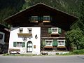
Old Montafon house in Partenen
Franz Joseph Rudigier's birthplace
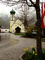
Kuratienkirche Partenen
.JPG)


Economy and Infrastructure
Like many other places in the Montafon , the inhabitants of Partenen also live mainly from tourism and the winter season plays a very important role. There are numerous ascent aids in the form of lifts and cable cars available, both to the Silvretta Nova ski area and via the Vermuntbahn to Bielerhöhe .
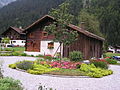
There are many hiking trails for summer guests and numerous private guest houses and hotels invite you to stay. In Partenen, efforts are made to maintain the appearance of the place accordingly.
In the village of Partenen, it is important that local products from agriculture are marketed in the tourism sector. One of these initiatives is called the Montafon Sura Kees enjoyment region .

Partener Surah Kees

Parten mountain cheese

Montafon oven bread

Montafon ham & bacon


Web links
Individual evidence
- ↑ a b about f & b hiking map sheet 37 Rhätikon-Silvretta group 1: 100000, approx. 1960s
- ^ Message from Werner Vogt from October 29, 2019.
- ↑ Alarm plan from 2018 of the Office of the City of Bludenz, see https://www.bludenz.at/fileadmin/user_upload/Typhon_kops_silvretta_und_vermunt_18_12_2018.pdf
- ↑ "Like a dusty comet" - The first bus to Inner Fratte ( memento of the original from January 3, 2016 in the Internet Archive ) Info: The archive link was inserted automatically and has not yet been checked. Please check the original and archive link according to the instructions and then remove this notice. (PDF; 6.0 MB).
- ↑ , notices of forest Federal Research Institute Vienna, page 32 on 24 July 2020, taking https://www.zobodat.at/pdf/Mitteilungen-forstlichen-Bundes-Versuchsanstalt_87_1970_0001-0062.pdf seen
-
^ Kurt Klein (edit.): Historical local dictionary . Statistical documentation on population and settlement history. Ed .: Vienna Institute of Demography [VID] d. Austrian Academy of Sciences . Vorarlberg , Partenen
, S.
16 ( online document , explanations . Suppl . ; both PDF - oD [updated]). Special references: 1810: Kgl. Bavarian population census 1809/10 ( Montgelas census ) . In: Bayerische Staatsbibliothek München (Ed.): Manuscript collection. Volume Cgm 6845/10, pp. 18-22 · 1823: Population Census . In: General national calendar for Tyrol and Vorarlberg. Volume 5. Innsbruck 1825, p. 29 ff. 1837: Johann Jakob Staffler : Population census . In: Tyrol and Vorarlberg, statistical and topographical, with historical remarks. Volume 2nd part, 1st volume. 1841 · 1869: Statistical Central Commission (ed.): Local repertories of the kingdoms and countries represented in the Austrian Imperial Council. 1871 ff. · 1880, 1890: Statistical Central Commission: Special local repertories of the kingdoms and countries represented in the Austrian Imperial Council. 1883 resp. 1892 ff. 1900: Central Statistical Commission: Community lexicon of the kingdoms and countries represented in the Reichsrat. 1903 ff. 1910: Statistical Central Commission: Special Repertories. 1915 ff. 1951 and later: Austrian Central Statistical Office (ed.): Ortverzeichnis . (Results of the census).

Cadastral communities: Gaschurn • Localities and counting districts: Gaschurn | Partenen
Villages:
Gaschurn •
Rotten:
Auserbach |
Outside sofa |
Aussergosta |
Bielerhöhe |
Gufelgut |
Gundalatscherberg |
Inner bofa |
Innergosta |
Hole |
Motta |
Partenen |
Catches |
Pfolla |
Rifa |
Trantrauas |
Vand |
Angle |
Zeinisjoch •
Other settlements:
Heilbronner Hütte |
Klostertaler Hut |
Madlenerhaus |
Rifawerk |
Saarbrücker Hut |
Tübinger Hut |
Alpe Valschaviel |
Wiesbadener Hut |
Zeinisjochhaus