
Wall (bathing)
| coat of arms | Germany map | |
|---|---|---|

|
Coordinates: 49 ° 20 ' N , 8 ° 48' E |
|
| Basic data | ||
| State : | Baden-Württemberg | |
| Administrative region : | Karlsruhe | |
| County : | Rhein-Neckar district | |
| Height : | 131 m above sea level NHN | |
| Area : | 6.3 km 2 | |
| Residents: | 4006 (December 31, 2018) | |
| Population density : | 636 inhabitants per km 2 | |
| Postal code : | 69256 | |
| Area code : | 06226 | |
| License plate : | HD | |
| Community key : | 08 2 26 048 | |
| LOCODE : | DE MUX | |
| Address of the municipal administration: |
Heidelberger Strasse 34 69256 Wall |
|
| Website : | ||
| Mayor : | John Ehret | |
| Location of the community of Mauer in the Rhein-Neckar district | ||
  |
||

Mauer is a municipality in Baden-Württemberg that belongs to the Rhein-Neckar district . The place with almost 4000 inhabitants is internationally known as the place where the lower jaw of Mauer was found , a type specimen of Homo heidelbergensis .
geography
Mauer belongs to the Rhine-Neckar metropolitan region and is located in the northern Kraichgau at the transition to the Odenwald in the Elsenz valley between Heidelberg (17 kilometers) and Sinsheim (13 kilometers) at an altitude of around 130 to almost 240 meters. The municipal area extends over 630 hectares. Of this, 22.8 percent are settlement and traffic areas, 55.3 percent are used for agriculture and 18.6 percent are forested.
Adjacent communities are, starting in the north clockwise, Wiesenbach , Meckesheim , Wiesloch , Leimen and Bammental .
history
Until the 18th century
Mauer was first mentioned in a document in 1048 as "Muron", which means "wall". It is unknown from which building the name is derived. The first settlement probably took place in the 8th or 9th century, as the neighboring communities in the Elsenz Valley were also settled around this time. The place belonged to the Hohenstaufen Reichsland around Wimpfen and came with the Meckesheimer Zent around 1330 to the Electoral Palatinate . In the 13th and 14th centuries, the lords of Mauer, documented from 1208 to 1374, acted as local lords, after which the rulership structure changed frequently due to marriage and inheritance. Are mentioned u. a. those of Rosenberg , von Nippenburg , von Fechenbach , Vick von Reval, von Bettendorf and von Zyllnhardt . The last noble family to be enfeoffed with the Wall in 1831 were the Barons Göler von Ravensburg , who lived in the village until 2002.
During the Thirty Years War the Bavarians looted the village in 1622 and the Swedes in 1634. It is believed that Melac's troops burned it down in 1689 . There was a moated castle in the village since the high Middle Ages, which was demolished in 1778.
Mauer experienced some boost from the expansion of the Chaussee from Neckargemünd to Heilbronn around 1780. Even Goethe came on a trip to Switzerland on August 27, 1797 by wall and has the place a few lines dedicated to "Wall [...] is friendly; a kind of poplar avenue leads from the village to a pleasure house. The women have a Catholic, not unpleasant, education; the men are polite, not a trace of rudeness; one rather notices a moral calm. Beets and hemp stood alone in the fields. Behind the village there is an avenue of cherry trees on the Chaussee, which goes through the wet meadows; it is improved with limestone [...] "

The mining of sand in Mauer has been documented since 1584 and there were numerous large sand pits . The reason for this is that up to half a million years ago the Neckar did not flow in its current bed, but rather ran in a long south loop over the area of Mauer and deposited gravel and sand banks here; The elongated Neckargemünd - Bammentaler Holmut further north, which is striking in the landscape, is the Umlaufberg belonging to the old loop . In the “Grafenrain” sand pit, Daniel Hartmann found the very well-preserved lower jaw of Mauer on October 21, 1907 , which Otto Schoetensack later described scientifically and assigned to the new species Homo heidelbergensis . Finding the bones in layers of sediment several meters thick suggests that prehistoric man did not live here, but that the Ur-Neckar transported and deposited the lower jaw together with sand and gravel. Numerous other fossil bones from various animal species were found in the Mauer sand pits. The sand mining in the "Grafenrain" was stopped in 1962.
19th century
In 1803 Mauer came to Baden and was subordinated to the Neckargemünd Office. In 1807 a manorial office Mauer was established, which was directly subordinate to the Oberamt Heidelberg . In 1813 Mauer fell back to Neckargemünd, with which it came to the Eberbach office in 1857. Since 1864, Mauer belonged to the Heidelberg office, which first became the Heidelberg district and later today's Rhein-Neckar district .
In the 19th century there were repeated strong floods of the Elsenz in Mauer . In 1862 the railway line went into operation in the Elsenz Valley , and from 1898 a workers' train ran to Heidelberg. In 1902 electric lighting came into the village.
20th century
Politically, the center was the strongest party, which was only briefly overtaken by the Social Democrats at the beginning of the Weimar Republic . From 1930 the NSDAP received the most votes.
With the beginning of the war in 1939 , many male residents were drafted, so that companies later closed due to a lack of workers. The shortage was most noticeable in agriculture, where more women had to work in the fields. Towards the end of World War II , Mauer was attacked by low-flying planes aiming at the local glue factory.
After 1945 the community experienced its greatest growth; Immediately after the war, 416 expellees were assigned to Mauer , who at first could not even be provided with living space. Over the years since then, Mauer continued to grow and during the “ economic miracle ” it developed into a residential community with good infrastructure and a lively club life. Politically, as in most communities in Baden-Württemberg, the CDU became the dominant party. When the district of Heidelberg was dissolved , Mauer became part of the new Rhein-Neckar district in 1973 .
In 1994 Mauer, like other villages in the Elsenz Valley, was hit by one of the worst floods of the 20th century, which is why new dams were built. With the construction of a western bypass road through the Wiesental on the opposite side of the Elsenz, the town center, which 16,000 vehicles had previously crossed daily, was calmed down again.
21st century
In the years from 2000 two large new building areas were designated, after whose development the population increased again sharply.
In 2012, in Mauer, John Ehret, a black man was elected mayor for the first time in Baden-Württemberg .
Population development
The increase in population in Mauer was interrupted in the 17th century by the Thirty Years' War and the subsequent French Wars . Increased growth occurred around 1780 in the course of the expansion of the road, the number of local residents stagnated due to poverty in the middle of the 19th century and then grew rapidly again with industrialization and railway construction. After the Second World War, the community took in numerous expellees.

Religions
In 1522 the Reformation was introduced in Mauer ; probably by Franz von Sickingen . Today there is both a Protestant and a Roman Catholic parish in the village.
politics

Municipal council
The municipal council has 14 members who are directly elected every five years. The mayor is also the chairman of the municipal council.
The 2019 local elections led to the following result (in brackets: difference to 2014):
| City council election 2019 | |||||
| Political party | be right | Seats | |||
| CDU | 37.1% (−4.3) | 5 (−1) | |||
| Independent for Wall ( voter group ) | 25.6% (+2.9) | 4 (+1) | |||
| SPD | 20.6% (−5.8) | 3 (−1) | |||
| Green | 16.7% (16.7) | 2 (+2) | |||
| Turnout: 70.1% (+5.5) | |||||
mayor
- 1945–1946: Friedrich Heid
- 1946–1948: Johann Müller
- 1948–1954: Friedrich Zimmermann
- 1954–1962: Johann Müller
- 1962–1976: Gerhard Weiser ( CDU )
- 1976-2001: Erich Mick ( CDU )
- 2001–2012: Jörg Albrecht (independent)
- from June 1, 2012: John Ehret (independent)
coat of arms
The blazon of the coat of arms reads: In silver on a green ground a red wall with four battlements.
Even the ministerial family, who ruled the wall in the 13th century, had the talking image of the wall in their coat of arms . The court seal of the place, which can be proven since 1752, also showed the wall. The General State Archives created the coat of arms in 1911 based on these historical templates.
The flag is green and red. It is not known since when it has been run.
Culture and sights
Museums
There is a prehistoric museum in the town hall.
Buildings


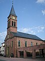
- The Catholic Church of St. Bartholomew was built in 1876 in place of a previous structure from 1772 and renovated in 1950.
- The Protestant church was built in 1896 in neo-Gothic style according to plans by building officer Hermann Behaghel . During a renovation in 1957, the roof was simplified.
- Lustschlösschen carefree , built in 1788 under Karl von Zyllnhardt on the opposite side of the mountain in the Elsenz valley. The castle, which was once outside of the village, can be reached via a road, is one of the smallest feudal buildings in the Rhine-Neckar area. Today it forms the end of the development at the exit to Schatthausen.
- Today's town hall was originally built around 1900 as a school building. Only after the old town hall was demolished in 1864 was it converted into town hall.
- The Heid'sche Haus is a striking half-timbered house in the center of the village, which houses the library and an exhibition on Homo heidelbergensis .
Catholic Church

Evang. church

Heid's house

Grafenrain sand pit


Natural monuments
The Grafenrain sand pit was transformed into a nature park and exemplarily shows the sediment layer situation on a 25 meter high section of the terrain, which corresponds to that of the homo heidelbergensis (which is no longer accessible today) .
Economy and Infrastructure
traffic
The Elsenz Valley Railway , built in 1862, and the B 45 ( Sinsheim - Wöllstadt ) run through the Elsenz Valley .
The community is connected to the RheinNeckar S-Bahn with the S5 (Heidelberg – Sinsheim – Eppingen) or S51 (Heidelberg – Meckesheim – Aglasterhausen) line. Mauer belongs to the tariff area of the Rhein-Neckar transport association .
education
The Norbert Preiß School is a primary school . In addition, three outside classes from the Stephen Hawking School Neckargemünd are housed in the school. Secondary schools can be attended in Neckargemünd, Bammental and Sinsheim. The community runs a library. For the youngest residents there is a Protestant and a Roman Catholic kindergarten .
Personalities
.JPG)
Honorary citizen
- Daniel Hartmann (1854–1952) found the lower jaw of Homo heidelbergensis
- Gerhard Weiser (1931–2003) was mayor of Mauer from 1962 to 1976. In 1968 he entered the state parliament for the first time and later became Minister of Agriculture in Baden-Württemberg from 1976 to 1996. From 1996 to 2001 he was Vice President of the State Parliament. Despite his political commitment, he remained connected to his hometown and also ran a farm there.
- Erich Mick, mayor from 1976 to 2001, founder of the Homo heidelbergensis von Mauer eV association
Other people connected to the wall
- Karl von Zyllnhardt (forester) (1744–1816), German landlord and forest clerk
- Karl von Zyllnhardt (lawyer) (1779–1828), German lawyer and politician
literature
- State Archive administration Baden-Württemberg in connection with d. Cities and districts Heidelberg u. Mannheim (ed.): The city and districts of Heidelberg and Mannheim: Official district description .
- Vol. 1: General part . Karlsruhe 1966
- Vol. 2: The city of Heidelberg and the municipalities of the district of Heidelberg . Karlsruhe 1968
- Albert Haaf: My home. Wall at the Elsenz . Wall municipal administration, 2nd edition, Sinsheim 1975.
Individual evidence
- ↑ State Statistical Office Baden-Württemberg - Population by nationality and gender on December 31, 2018 (CSV file) ( help on this ).
- ↑ Statistisches Landesamt Baden-Württemberg, status: December 31, 2010 ( page no longer available , search in web archives ) Info: The link was automatically marked as defective. Please check the link according to the instructions and then remove this notice.
- ↑ Johann Wolfgang von Goethe: Heidelberg has something ideal , Sinsheim 1797, in: Heidelberg in old and new travel descriptions , selected. by Sabine Underwood, Droste Verlag, Düsseldorf 1993.
- ^ Spiegel Online : As Commissioner Ehret writes history , accessed on June 1, 2012.
- ↑ State Statistical Office of Baden-Württemberg: Municipal council elections 2019, Wall ; Parish of Mauer: City Council Election 2019 (PDF) ; accessed June 1, 2019.
- ↑ From the BKA to the town hall: Almost 60 percent said “Yes, we can” . In: Stuttgarter Zeitung of May 7, 2012
- ^ Herwig John, Gabriele Wüst: Wappenbuch Rhein-Neckar-Kreis . Ubstadt-Weiher 1996, ISBN 3-929366-27-4 , p. 79
Web links

Altlußheim | Angelbachtal | Bammental | Brühl | Dielheim | Dossenheim | Eberbach | Edingen-Neckarhausen | Epfenbach | Eppelheim | Eschelbronn | Gaiberg | Heddesbach | Heddesheim | Heiligkreuzsteinach | Helmstadt-Bargen | Hemsbach | Hirschberg an der Bergstrasse | Hockenheim | Ilvesheim | Ketch | Ladenburg | Laudenbach | Gluing | Lobbach | Malsch | Wall | Meckesheim | Mulhouse | Neckarbischofsheim | Neckargemünd | Neidenstein | Neulußheim | Nut hole | Oftersheim | Plankstadt | Rauenberg | Reichartshausen | Reilingen | Sandhausen | Schönau | Schönbrunn | Schriesheim | Schwetzingen | Sinsheim | Spechbach | St. Leon-Rot | Waibstadt | Walldorf | Weinheim | Wiesenbach | Wiesloch | Wilhelmsfeld | Zuzenhausen